Property Record
1204 Mack St, Gaston, SC 29053


Save to a Folder
{{folder.Name}}
{{folder.ListingIds.length}} Properties
{{folder.ListingIds.length}} Property
Create a New Folder
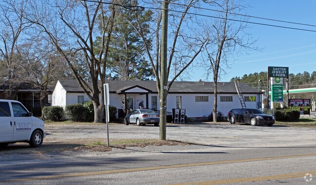
Property Detail
1204 Mack St
010117-03-027
Lexington
Restaurantdrivein
South Carolina
B and X Area of moderate flood hazard, usually the area between the limits of the 100-year and 500-year floods.
1
2025
0.41 AC
2025
Outlying Lexington County
020802
Columbia
1,732 SF
Columbia, SC
NEARBY LISTINGS FOR SALE OR LEASE
-
-
View all Gaston listings for sale on LoopNet.com
DEMOGRAPHICS near 1204 Mack St
1 mile
3 mile
5 mile
2025 Total Population
1,525
9,601
22,478
2030 Population
1,620
10,246
24,001
Pop Growth 2025-2030
+ 6.23%
+ 6.72%
+ 6.78%
Average Age
39
39
39
2025 Total Households
552
3,504
8,311
HH Growth 2025-2030
+ 6.52%
+ 6.88%
+ 6.92%
Median Household Inc
$54,130
$49,465
$52,700
Avg Household Size
2.60
2.60
2.60
2025 Avg HH Vehicles
2.00
2.00
2.00
Median Home Value
$112,376
$124,812
$142,721
Median Year Built
1992
1993
1993
Nearby Places
Map Layers
Map Styles
 Street
 Aerial
Layers
 Traffic
 Biking
Places
Listings with unknown addresses are not visible on the map
- Restaurants
- Banks
- Shops
- Fitness
- Groceries
PUBLIC TRANSPORTATION
AIRPORT
Columbia Metro
Drive
Walk
Distance
Columbia Metro
25 min
13.7 mi
Nearby Properties
Address
Land Use
TOTAL SIZE
Lot Size
Zoning
Address
Land Use
TOTAL SIZE
Lot Size
Zoning
39,216 SF
271.81 AC
ID
Address
Land Use
TOTAL SIZE
Lot Size
Zoning
9,180 SF
10.66 AC
Address
Land Use
TOTAL SIZE
Lot Size
Zoning
7,150 SF
2.46 AC
Address
Land Use
TOTAL SIZE
Lot Size
Zoning
12,400 SF
1.62 AC
RD
Address
Land Use
TOTAL SIZE
Lot Size
Zoning
5,880 SF
1 AC
Address
Land Use
TOTAL SIZE
Lot Size
Zoning
6,840 SF
0.82 AC
Address
Land Use
TOTAL SIZE
Lot Size
Zoning
18,358 SF
1.75 AC
RD
Address
Land Use
TOTAL SIZE
Lot Size
Zoning
3,360 SF
1.34 AC
RD
Address
Land Use
TOTAL SIZE
Lot Size
Zoning
23,387 SF
8.32 AC
ID
Address
Land Use
TOTAL SIZE
Lot Size
Zoning
5,828 SF
2.04 AC
Address
Land Use
TOTAL SIZE
Lot Size
Zoning
800 SF
418.19 AC
RD
Address
Land Use
TOTAL SIZE
Lot Size
Zoning
27.47 AC
ID
Address
Land Use
TOTAL SIZE
Lot Size
Zoning
26.40 AC
Address
Land Use
TOTAL SIZE
Lot Size
Zoning
3,153 SF
1 AC
Address
Land Use
TOTAL SIZE
Lot Size
Zoning
1,216 SF
7.47 AC
RD
Address
Land Use
TOTAL SIZE
Lot Size
Zoning
18,225 SF
2.37 AC
LR
Address
Land Use
TOTAL SIZE
Lot Size
Zoning
2,400 SF
12 AC
RD
Address
Land Use
TOTAL SIZE
Lot Size
Zoning
134.04 AC
LR
Address
Land Use
TOTAL SIZE
Lot Size
Zoning
1,008 SF
9.82 AC
RD
Address
Land Use
TOTAL SIZE
Lot Size
Zoning
10,986 SF
187.28 AC
LR
Address
Land Use
TOTAL SIZE
Lot Size
Zoning
1.64 AC
Address
Land Use
TOTAL SIZE
Lot Size
Zoning
5,000 SF
3.43 AC
Address
Land Use
TOTAL SIZE
Lot Size
Zoning
231.10 AC
Address
Land Use
TOTAL SIZE
Lot Size
Zoning
6,791 SF
0.85 AC
Address
Land Use
TOTAL SIZE
Lot Size
Zoning
3,140 SF
0.99 AC
Address
Land Use
TOTAL SIZE
Lot Size
Zoning
2,400 SF
1.43 AC
LR
Address
Land Use
TOTAL SIZE
Lot Size
Zoning
176 AC
LR
Address
Land Use
TOTAL SIZE
Lot Size
Zoning
1,500 SF
2.34 AC
LR
Address
Land Use
TOTAL SIZE
Lot Size
Zoning
3,612 SF
1 AC
RD
Address
Land Use
TOTAL SIZE
Lot Size
Zoning
1,800 SF
14.33 AC
LR
The World's #1 Commercial Real Estate Marketplace
Connect with us
© 2026 CoStar Group
The information above has been obtained from sources believed reliable. While we do not doubt its accuracy we have not verified it and make no guarantee, warranty or representation about it. It is your responsibility to independently confirm its accuracy and completeness. Any projections, opinions, assumptions, or estimates used are for example only and do not represent the current or future performance of the property. The value of this transaction to you depends on tax and other factors which should be evaluated by your tax, financial, and legal advisors. You and your advisors should conduct a careful, independent investigation of the property to determine to your satisfaction the suitability of the property for your needs.