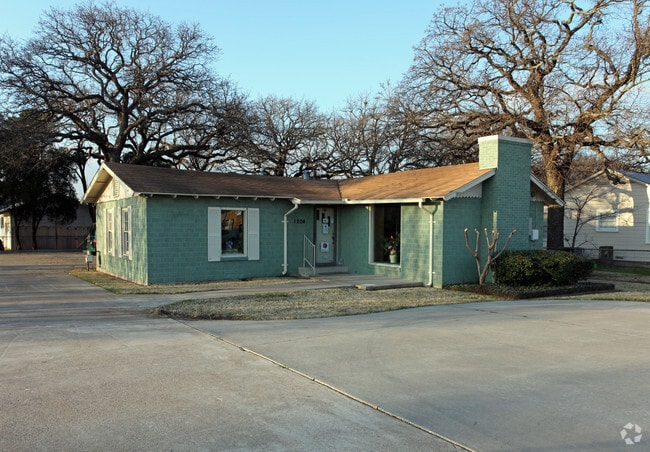
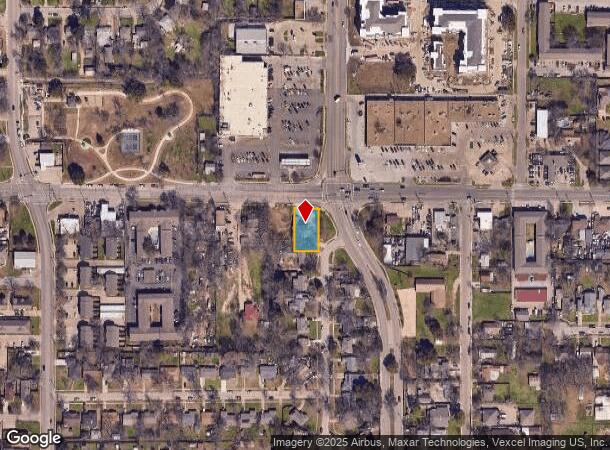
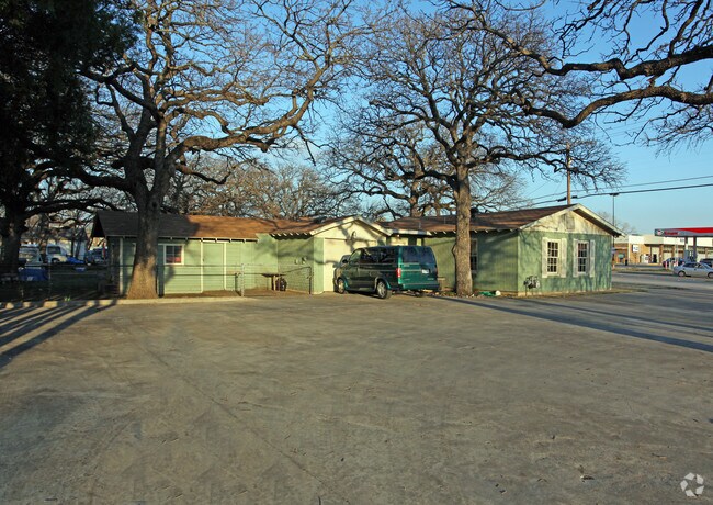
Property Record
1204 W 6Th St, Irving, TX 75060
NEARBY LISTINGS FOR SALE OR LEASE
Property Detail
1204 W 6Th St
Dallas-Fort Worth-Arlington, TX
Landolt Acres
32256500010020000
LANDOLT ACRES BLK A LT 2 LESS ROW ACS 0.2487 INT202300010512 DD01162023 CO-DC 2565000100200 1CI25650001
Commercialnec
Dallas
X
Texas
48113C0315L
2
2024
0.25 AC
2025
Irving
015206
Dallas/Ft Worth
1,356 SF
DEMOGRAPHICS near 1204 W 6Th St
1 Mile
3 Mile
5 Mile
2024 Total Population
20,059
109,733
221,518
2029 Population
19,948
108,267
219,203
Pop Growth 2024-2029
(0.55%)
(1.34%)
(1.05%)
Average Age
35
36
35
2024 Total Households
6,053
34,516
77,579
HH Growth 2024-2029
(0.81%)
(1.57%)
(1.13%)
Median Household Inc
$59,663
$58,897
$62,724
Avg Household Size
3.20
3.10
2.70
2024 Avg HH Vehicles
2.00
2.00
2.00
Median Home Value
$212,839
$210,732
$217,178
Median Year Built
1968
1970
1979
Nearby Places
Map Layers
Map Styles
 Street
 Aerial
- Restaurants
- Banks
- Shops
- Fitness
- Groceries
PUBLIC TRANSPORTATION
COMMUTER RAIL
Downtown Irving/Heritage Crossing Station (TRINITY RAILWAY - Dallas Area Rapid Transit (DART), Trinity Railway Express - Dallas Area Rapid Transit (DART))
DRIVE
WALK
Distance
Downtown Irving/Heritage Crossing Station (TRINITY RAILWAY - Dallas Area Rapid Transit (DART), Trinity Railway Express - Dallas Area Rapid Transit (DART))
3 min
1.2 mi
West Irving (TRINITY RAILWAY - Dallas Area Rapid Transit (DART), Trinity Railway Express - Dallas Area Rapid Transit (DART))
DRIVE
WALK
Distance
West Irving (TRINITY RAILWAY - Dallas Area Rapid Transit (DART), Trinity Railway Express - Dallas Area Rapid Transit (DART))
8 min
3.4 mi
AIRPORT
Dallas-Fort Worth International
DRIVE
WALK
Distance
Dallas-Fort Worth International
17 min
10.7 mi
Dallas Love Field
DRIVE
WALK
Distance
Dallas Love Field
20 min
10.9 mi
Freight Ports
Port of Shreveport
DRIVE
WALK
Distance
Port of Shreveport
229 min
209.3 mi
Nearby Properties
Address
Land Use
TOTAL SIZE
Lot Size
Zoning
Address
Land Use
TOTAL SIZE
Lot Size
Zoning
496,283 SF
246.29 AC
Z236
Address
Land Use
TOTAL SIZE
Lot Size
Zoning
151,552 SF
16 AC
Z58
Address
Land Use
TOTAL SIZE
Lot Size
Zoning
585,000 SF
27.06 AC
Z123
Address
Land Use
TOTAL SIZE
Lot Size
Zoning
168,598 SF
11.33 AC
Z128
Address
Land Use
TOTAL SIZE
Lot Size
Zoning
602,000 SF
72.59 AC
Z123
Address
Land Use
TOTAL SIZE
Lot Size
Zoning
241,780 SF
16.46 AC
RMR2
Address
Land Use
TOTAL SIZE
Lot Size
Zoning
643,370 SF
22.95 AC
Z393
Address
Land Use
TOTAL SIZE
Lot Size
Zoning
120,000 SF
9.94 AC
Z393
Address
Land Use
TOTAL SIZE
Lot Size
Zoning
268,930 SF
46.40 AC
Z325
Address
Land Use
TOTAL SIZE
Lot Size
Zoning
294,460 SF
14.78 AC
Z392
Address
Land Use
TOTAL SIZE
Lot Size
Zoning
397,711 SF
18.27 AC
Z123
Address
Land Use
TOTAL SIZE
Lot Size
Zoning
237,472 SF
9.31 AC
Z176
Address
Land Use
TOTAL SIZE
Lot Size
Zoning
327,975 SF
18.46 AC
Z393
Address
Land Use
TOTAL SIZE
Lot Size
Zoning
242,652 SF
12.31 AC
Z392
Address
Land Use
TOTAL SIZE
Lot Size
Zoning
193,233 SF
10.19 AC
RMR2
Address
Land Use
TOTAL SIZE
Lot Size
Zoning
181,389 SF
8.46 AC
Z176
Address
Land Use
TOTAL SIZE
Lot Size
Zoning
401,311 SF
13.68 AC
Z58
Address
Land Use
TOTAL SIZE
Lot Size
Zoning
1,035,018 SF
43.12 AC
Address
Land Use
TOTAL SIZE
Lot Size
Zoning
245,800 SF
12.59 AC
Address
Land Use
TOTAL SIZE
Lot Size
Zoning
81,210 SF
53.19 AC
Z324
Address
Land Use
TOTAL SIZE
Lot Size
Zoning
196,670 SF
10.64 AC
Z177
Address
Land Use
TOTAL SIZE
Lot Size
Zoning
206,856 SF
10.20 AC
Z177
Address
Land Use
TOTAL SIZE
Lot Size
Zoning
406,496 SF
42.49 AC
Z128
Address
Land Use
TOTAL SIZE
Lot Size
Zoning
220,762 SF
14.77 AC
Z176
Address
Land Use
TOTAL SIZE
Lot Size
Zoning
143,916 SF
7.22 AC
Z177
Address
Land Use
TOTAL SIZE
Lot Size
Zoning
192,346 SF
9.89 AC
Z392
Address
Land Use
TOTAL SIZE
Lot Size
Zoning
162,612 SF
7.81 AC
Z392
Address
Land Use
TOTAL SIZE
Lot Size
Zoning
142,650 SF
9.18 AC
RMR2
Address
Land Use
TOTAL SIZE
Lot Size
Zoning
98,200 SF
9.40 AC
Z290
Address
Land Use
TOTAL SIZE
Lot Size
Zoning
97,779 SF
50.53 AC
Z324
The World's #1 Commercial Real Estate Marketplace
Connect with us
© 2025 CoStar Group
The information above has been obtained from sources believed reliable. While we do not doubt its accuracy we have not verified it and make no guarantee, warranty or representation about it. It is your responsibility to independently confirm its accuracy and completeness. Any projections, opinions, assumptions, or estimates used are for example only and do not represent the current or future performance of the property. The value of this transaction to you depends on tax and other factors which should be evaluated by your tax, financial, and legal advisors. You and your advisors should conduct a careful, independent investigation of the property to determine to your satisfaction the suitability of the property for your needs.