Property Record
12042 S Carlsbad Way, Herriman, UT 84096
NEARBY LISTINGS FOR SALE OR LEASE
-
-
NWC Mountain View Corridor & 12600 South
Herriman, UT 84096
Rent Upon Request
0.93 - 6.80 AC Lot
Land
-
-
-
-
-
-
-
-
-
-
View all Herriman listings for sale on LoopNet.com
Property Detail
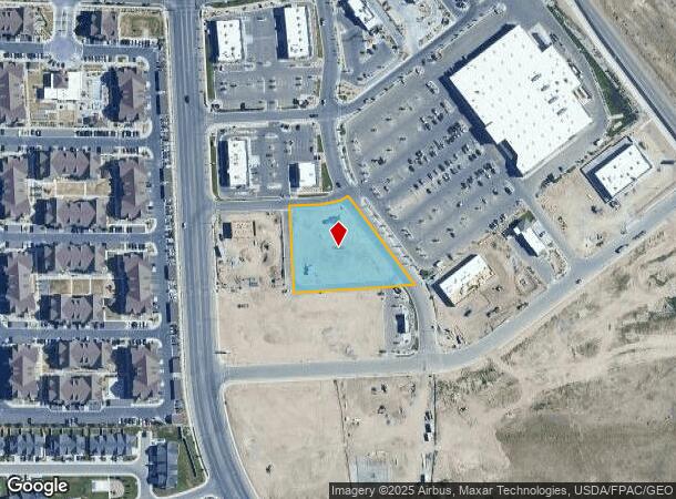
12042 S Carlsbad Way
Salt Lake City, UT
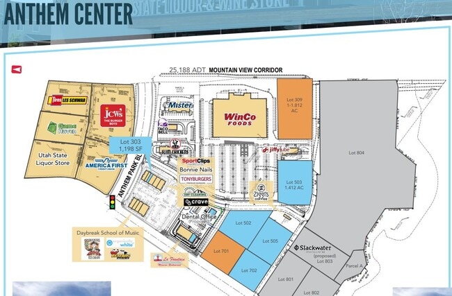
Anthem Commercial 5Th Amd Sub
26-25-178-008-0000
LOT 502, ANTHEM COMMERCIAL 5TH AMD SUB
Commercialacreage
Salt Lake
X
Utah
49035C0417G
502
2024
1.34 AC
2025
Southwest Valley
113114
Salt Lake City
DEMOGRAPHICS near 12042 S Carlsbad Way
1 Mile
3 Mile
5 Mile
2024 Total Population
20,057
102,668
210,585
2029 Population
20,578
105,036
214,425
Pop Growth 2024-2029
+ 2.60%
+ 2.31%
+ 1.82%
Average Age
31
32
34
2024 Total Households
6,237
29,373
59,972
HH Growth 2024-2029
+ 2.68%
+ 2.35%
+ 1.79%
Median Household Inc
$89,112
$109,723
$109,607
Avg Household Size
3.20
3.50
3.50
2024 Avg HH Vehicles
2.00
2.00
2.00
Median Home Value
$466,100
$496,580
$498,982
Median Year Built
2010
2010
2007
Nearby Places
Map Layers
Map Styles
 Street
 Aerial
- Restaurants
- Banks
- Shops
- Fitness
- Groceries
PUBLIC TRANSPORTATION
COMMUTER RAIL
DRIVE
WALK
Distance
15 min
7.3 mi
DRIVE
WALK
Distance
17 min
7.9 mi
AIRPORT
Salt Lake City International
DRIVE
WALK
Distance
Salt Lake City International
29 min
20.3 mi
Provo Municipal
DRIVE
WALK
Distance
Provo Municipal
44 min
33.1 mi
SALE & LEASE HISTORY
LISTING DATE
SALE/LEASE

Nov 12, 2021
For Sale
Nearby Properties
Address
Land Use
TOTAL SIZE
Lot Size
Zoning
Address
Land Use
TOTAL SIZE
Lot Size
Zoning
540,554 SF
63.03 AC
C-R
Address
Land Use
TOTAL SIZE
Lot Size
Zoning
340,894 SF
60.46 AC
P-C
Address
Land Use
TOTAL SIZE
Lot Size
Zoning
285,200 SF
55.78 AC
1210
Address
Land Use
TOTAL SIZE
Lot Size
Zoning
284,727 SF
26.33 AC
4144
Address
Land Use
TOTAL SIZE
Lot Size
Zoning
554,682 SF
30.25 AC
SLR-SP
Address
Land Use
TOTAL SIZE
Lot Size
Zoning
126,150 SF
25.43 AC
RM
Address
Land Use
TOTAL SIZE
Lot Size
Zoning
591,044 SF
13.87 AC
C-2
Address
Land Use
TOTAL SIZE
Lot Size
Zoning
469,074 SF
5.14 AC
C-P
Address
Land Use
TOTAL SIZE
Lot Size
Zoning
702,100 SF
13.83 AC
P-C
Address
Land Use
TOTAL SIZE
Lot Size
Zoning
73,318 SF
1.36 AC
PC
Address
Land Use
TOTAL SIZE
Lot Size
Zoning
241,215 SF
51.07 AC
M-1
Address
Land Use
TOTAL SIZE
Lot Size
Zoning
269,342 SF
12.68 AC
MU-2
Address
Land Use
TOTAL SIZE
Lot Size
Zoning
857,680 SF
75.49 AC
M-1
Address
Land Use
TOTAL SIZE
Lot Size
Zoning
323,922 SF
30.86 AC
PCC
Address
Land Use
TOTAL SIZE
Lot Size
Zoning
135,314 SF
21.59 AC
1115
Address
Land Use
TOTAL SIZE
Lot Size
Zoning
137,750 SF
12.64 AC
1210
Address
Land Use
TOTAL SIZE
Lot Size
Zoning
256,933 SF
19.68 AC
P-C
Address
Land Use
TOTAL SIZE
Lot Size
Zoning
59,711 SF
4.77 AC
C-2
Address
Land Use
TOTAL SIZE
Lot Size
Zoning
425,753 SF
2.28 AC
PC
Address
Land Use
TOTAL SIZE
Lot Size
Zoning
398,447 SF
11.04 AC
BMHU
Address
Land Use
TOTAL SIZE
Lot Size
Zoning
348,043 SF
5.35 AC
PC
Address
Land Use
TOTAL SIZE
Lot Size
Zoning
100,474 SF
12.99 AC
R-M-18
Address
Land Use
TOTAL SIZE
Lot Size
Zoning
348,917 SF
6.23 AC
PC
Address
Land Use
TOTAL SIZE
Lot Size
Zoning
456,759 SF
28.63 AC
C-R
Address
Land Use
TOTAL SIZE
Lot Size
Zoning
554,777 SF
168.76 AC
M-1
Address
Land Use
TOTAL SIZE
Lot Size
Zoning
4.76 AC
PC
Address
Land Use
TOTAL SIZE
Lot Size
Zoning
232,874 SF
7.04 AC
RM-18
Address
Land Use
TOTAL SIZE
Lot Size
Zoning
227,345 SF
34.06 AC
M-1
Address
Land Use
TOTAL SIZE
Lot Size
Zoning
228,360 SF
41 AC
PCC
Address
Land Use
TOTAL SIZE
Lot Size
Zoning
239,900 SF
29.12 AC
P-C
The World's #1 Commercial Real Estate Marketplace
Connect with us
© 2025 CoStar Group
The information above has been obtained from sources believed reliable. While we do not doubt its accuracy we have not verified it and make no guarantee, warranty or representation about it. It is your responsibility to independently confirm its accuracy and completeness. Any projections, opinions, assumptions, or estimates used are for example only and do not represent the current or future performance of the property. The value of this transaction to you depends on tax and other factors which should be evaluated by your tax, financial, and legal advisors. You and your advisors should conduct a careful, independent investigation of the property to determine to your satisfaction the suitability of the property for your needs.