Property Record
12045 6300 Rd, Montrose, CO 81401
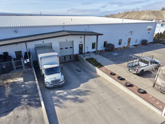

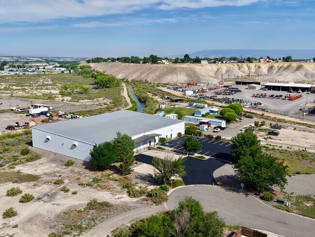

Property Detail
12045 6300 Rd
R0001251
S: 18 T: 49 R: 9 A TRT LD IN NENE 18-49-9 DAB AT NE COR SD SEC TH S 01D34M55S W 208 FT; TH N 88D16M59S W 610.13 FT; TH N
Warehouse
MONTROSE
B3
Colorado
B and X Area of moderate flood hazard, usually the area between the limits of the 100-year and 500-year floods.
3.15 AC
2025
Colorado Southwest Area
2025
Other Market Areas
966503
Montrose, CO
21,600 SF
NEARBY LISTINGS FOR SALE OR LEASE
-
-
View all Montrose listings for lease on LoopNet.com
DEMOGRAPHICS near 12045 6300 Rd
1 mile
3 mile
5 mile
2025 Total Population
567
7,802
25,680
2030 Population
596
8,228
26,882
Pop Growth 2025-2030
+ 5.11%
+ 5.46%
+ 4.68%
Average Age
47
41
43
2025 Total Households
249
3,033
10,565
HH Growth 2025-2030
+ 5.22%
+ 5.47%
+ 4.69%
Median Household Inc
$74,999
$58,600
$71,153
Avg Household Size
2.30
2.50
2.40
2025 Avg HH Vehicles
2.00
2.00
2.00
Median Home Value
$325,000
$282,948
$351,369
Median Year Built
1992
1993
1989
Nearby Places
Map Layers
Map Styles
 Street
 Aerial
Layers
 Traffic
 Biking
Places
Listings with unknown addresses are not visible on the map
- Restaurants
- Banks
- Shops
- Fitness
- Groceries
PUBLIC TRANSPORTATION
AIRPORT
Montrose Regional
Drive
Walk
Distance
Montrose Regional
5 min
1.4 mi
SALE & LEASE HISTORY
LISTING DATE
SALE/LEASE

Sep 04, 2025
For Lease
Feb 12, 2025
For Sale
Nearby Properties
Address
Land Use
TOTAL SIZE
Lot Size
Zoning
Address
Land Use
TOTAL SIZE
Lot Size
Zoning
67,223 SF
0.62 AC
Address
Land Use
TOTAL SIZE
Lot Size
Zoning
54,125 SF
18.15 AC
Address
Land Use
TOTAL SIZE
Lot Size
Zoning
21,000 SF
14.34 AC
Address
Land Use
TOTAL SIZE
Lot Size
Zoning
54,088 SF
79.70 AC
Address
Land Use
TOTAL SIZE
Lot Size
Zoning
51,727 SF
2.56 AC
Address
Land Use
TOTAL SIZE
Lot Size
Zoning
95,971 SF
4.68 AC
Address
Land Use
TOTAL SIZE
Lot Size
Zoning
38,729 SF
3.83 AC
Address
Land Use
TOTAL SIZE
Lot Size
Zoning
55,624 SF
3.49 AC
Address
Land Use
TOTAL SIZE
Lot Size
Zoning
18,441 SF
1.87 AC
Address
Land Use
TOTAL SIZE
Lot Size
Zoning
977.71 AC
Address
Land Use
TOTAL SIZE
Lot Size
Zoning
22,219 SF
6.27 AC
Address
Land Use
TOTAL SIZE
Lot Size
Zoning
34,601 SF
1.61 AC
Address
Land Use
TOTAL SIZE
Lot Size
Zoning
8,778 SF
4.36 AC
Address
Land Use
TOTAL SIZE
Lot Size
Zoning
46,828 SF
4.37 AC
Address
Land Use
TOTAL SIZE
Lot Size
Zoning
8,751 SF
5.08 AC
Address
Land Use
TOTAL SIZE
Lot Size
Zoning
22,479 SF
26.19 AC
Address
Land Use
TOTAL SIZE
Lot Size
Zoning
27,096 SF
Address
Land Use
TOTAL SIZE
Lot Size
Zoning
27,097 SF
Address
Land Use
TOTAL SIZE
Lot Size
Zoning
20,614 SF
3.28 AC
Address
Land Use
TOTAL SIZE
Lot Size
Zoning
46,783 SF
3.66 AC
I2
Address
Land Use
TOTAL SIZE
Lot Size
Zoning
16,882 SF
7.56 AC
Address
Land Use
TOTAL SIZE
Lot Size
Zoning
18,000 SF
7.74 AC
B3
Address
Land Use
TOTAL SIZE
Lot Size
Zoning
32,923 SF
Address
Land Use
TOTAL SIZE
Lot Size
Zoning
20,000 SF
12.16 AC
Address
Land Use
TOTAL SIZE
Lot Size
Zoning
24,414 SF
Address
Land Use
TOTAL SIZE
Lot Size
Zoning
22,736 SF
5.57 AC
Address
Land Use
TOTAL SIZE
Lot Size
Zoning
17,820 SF
9.61 AC
Address
Land Use
TOTAL SIZE
Lot Size
Zoning
13,816 SF
Address
Land Use
TOTAL SIZE
Lot Size
Zoning
9,886 SF
3.62 AC
B3
Address
Land Use
TOTAL SIZE
Lot Size
Zoning
19,500 SF
5.54 AC
The World's #1 Commercial Real Estate Marketplace
Connect with us
© 2026 CoStar Group
The information above has been obtained from sources believed reliable. While we do not doubt its accuracy we have not verified it and make no guarantee, warranty or representation about it. It is your responsibility to independently confirm its accuracy and completeness. Any projections, opinions, assumptions, or estimates used are for example only and do not represent the current or future performance of the property. The value of this transaction to you depends on tax and other factors which should be evaluated by your tax, financial, and legal advisors. You and your advisors should conduct a careful, independent investigation of the property to determine to your satisfaction the suitability of the property for your needs.