Property Record
1205 Al Highway 21 S, Oxford, AL 36203

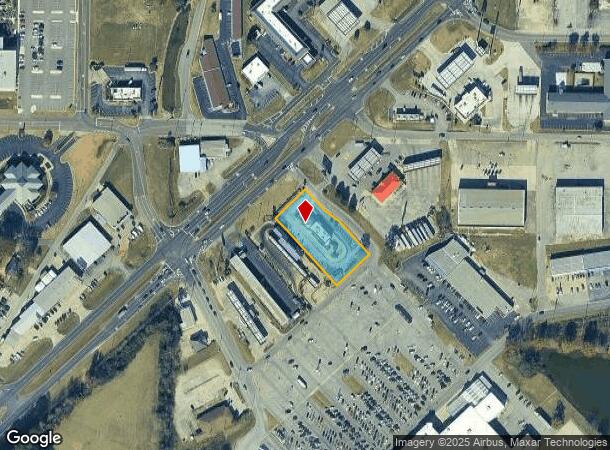


This Property Is For Sale
NEARBY LISTINGS FOR SALE OR LEASE
Property Detail
1205 Al Highway 21 S
Anniston-Oxford-Jacksonville, AL
S E Boozer Farm
21-09-30-4-001-044.008
SEC 30 TSP 16 R 8 S E BOOZER FARM SUB PT BLK 17 & PT LTS 8 & 9 & PT VACATED CEDAR ST BEG 241.19 SW OF SE INT AL HWY 21 & ELM
Restaurantdrivein
Calhoun
X
Alabama
01015C0402E
8,9
2025
0.96 AC
2025
Gadsden/Anniston Area
001103
Other Market Areas
3,497 SF
DEMOGRAPHICS near 1205 Al Highway 21 S
1 Mile
3 Mile
5 Mile
2024 Total Population
2,173
17,876
41,297
2029 Population
2,144
17,482
40,788
Pop Growth 2024-2029
(1.33%)
(2.20%)
(1.23%)
Average Age
41
40
42
2024 Total Households
841
7,133
16,850
HH Growth 2024-2029
(1.55%)
(2.38%)
(1.29%)
Median Household Inc
$34,673
$54,478
$49,851
Avg Household Size
2.30
2.40
2.30
2024 Avg HH Vehicles
2.00
2.00
2.00
Median Home Value
$110,544
$161,097
$145,868
Median Year Built
1969
1979
1976
Nearby Places
- Restaurants
- Banks
- Shops
- Fitness
- Groceries
PUBLIC TRANSPORTATION
COMMUTER RAIL
Anniston Amtrak Station (Crescent - Amtrak)
DRIVE
WALK
Distance
Anniston Amtrak Station (Crescent - Amtrak)
8 min
3.9 mi
Freight Ports
Port of Panama City
DRIVE
WALK
Distance
Port of Panama City
357 min
288.9 mi
Nearby Properties
Address
Land Use
TOTAL SIZE
Lot Size
Zoning
Address
Land Use
TOTAL SIZE
Lot Size
Zoning
128,399 SF
17 AC
Address
Land Use
TOTAL SIZE
Lot Size
Zoning
23,480 SF
14 AC
Address
Land Use
TOTAL SIZE
Lot Size
Zoning
5.32 AC
Address
Land Use
TOTAL SIZE
Lot Size
Zoning
126,689 SF
8.49 AC
Address
Land Use
TOTAL SIZE
Lot Size
Zoning
7,752 SF
182 AC
Address
Land Use
TOTAL SIZE
Lot Size
Zoning
18.90 AC
Address
Land Use
TOTAL SIZE
Lot Size
Zoning
1,972 SF
22.80 AC
Address
Land Use
TOTAL SIZE
Lot Size
Zoning
17,254 SF
22 AC
Address
Land Use
TOTAL SIZE
Lot Size
Zoning
87,750 SF
25 AC
Address
Land Use
TOTAL SIZE
Lot Size
Zoning
4,356 SF
60.40 AC
Address
Land Use
TOTAL SIZE
Lot Size
Zoning
1,335 SF
76 AC
Address
Land Use
TOTAL SIZE
Lot Size
Zoning
341,374 SF
15.88 AC
Address
Land Use
TOTAL SIZE
Lot Size
Zoning
201,670 SF
27.50 AC
Address
Land Use
TOTAL SIZE
Lot Size
Zoning
74,927 SF
2.47 AC
Address
Land Use
TOTAL SIZE
Lot Size
Zoning
346,532 SF
41 AC
Address
Land Use
TOTAL SIZE
Lot Size
Zoning
64,772 SF
2.56 AC
Address
Land Use
TOTAL SIZE
Lot Size
Zoning
56,520 SF
2.51 AC
Address
Land Use
TOTAL SIZE
Lot Size
Zoning
4,366 SF
0.97 AC
Address
Land Use
TOTAL SIZE
Lot Size
Zoning
102,436 SF
12.52 AC
Address
Land Use
TOTAL SIZE
Lot Size
Zoning
54,232 SF
2.27 AC
Address
Land Use
TOTAL SIZE
Lot Size
Zoning
50,180 SF
7.60 AC
Address
Land Use
TOTAL SIZE
Lot Size
Zoning
135,128 SF
10.01 AC
Address
Land Use
TOTAL SIZE
Lot Size
Zoning
14,015 SF
8.50 AC
Address
Land Use
TOTAL SIZE
Lot Size
Zoning
12,695 SF
0.75 AC
Address
Land Use
TOTAL SIZE
Lot Size
Zoning
86,508 SF
20 AC
Address
Land Use
TOTAL SIZE
Lot Size
Zoning
Address
Land Use
TOTAL SIZE
Lot Size
Zoning
31,104 SF
36 AC
Address
Land Use
TOTAL SIZE
Lot Size
Zoning
227,530 SF
24 AC
Address
Land Use
TOTAL SIZE
Lot Size
Zoning
4,118 SF
15.74 AC
Address
Land Use
TOTAL SIZE
Lot Size
Zoning
6,400 SF
12.24 AC
The World's #1 Commercial Real Estate Marketplace
Connect with us
© 2025 CoStar Group
The information above has been obtained from sources believed reliable. While we do not doubt its accuracy we have not verified it and make no guarantee, warranty or representation about it. It is your responsibility to independently confirm its accuracy and completeness. Any projections, opinions, assumptions, or estimates used are for example only and do not represent the current or future performance of the property. The value of this transaction to you depends on tax and other factors which should be evaluated by your tax, financial, and legal advisors. You and your advisors should conduct a careful, independent investigation of the property to determine to your satisfaction the suitability of the property for your needs.