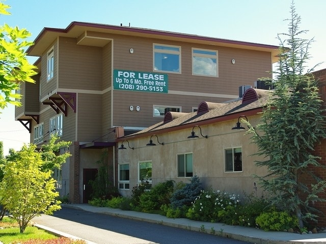
Property Record
1205 Highway 2, Sandpoint, ID 83864

Property Detail
1205 Highway 2
RPS00-000-226065A
22-57N-2W TAX 72 & 86 2 ROCK PLAZA
Commercialnec
Bonner
B and X Area of moderate flood hazard, usually the area between the limits of the 100-year and 500-year floods.
Idaho
2025
0.45 AC
2025
Bonner
950403
Coeur D'Alene
10,642 SF
Sandpoint, ID
NEARBY LISTINGS FOR SALE OR LEASE
DEMOGRAPHICS near 1205 Highway 2
1 mile
3 mile
5 mile
2025 Total Population
7,698
14,392
21,832
2030 Population
8,469
15,868
24,132
Pop Growth 2025-2030
+ 10.02%
+ 10.26%
+ 10.53%
Average Age
43
43
44
2025 Total Households
3,367
6,197
9,165
HH Growth 2025-2030
+ 9.71%
+ 9.92%
+ 10.17%
Median Household Inc
$71,546
$68,712
$70,537
Avg Household Size
2.20
2.20
2.30
2025 Avg HH Vehicles
2.00
2.00
2.00
Median Home Value
$524,735
$518,215
$512,443
Median Year Built
1981
1989
1991
Nearby Places
Map Layers
Map Styles
 Street
 Aerial
Transit
 Traffic
 Biking
Places
Listings with unknown addresses are not visible on the map
- Restaurants
- Banks
- Shops
- Fitness
- Groceries
SALE & LEASE HISTORY
LISTING DATE
SALE/LEASE

Sep 25, 2016
For Lease
Sep 23, 2016
For Sale
Jun 06, 2017
For Lease
Jun 06, 2017
For Sale
Feb 02, 2017
For Sale
Nearby Properties
Address
Land Use
TOTAL SIZE
Lot Size
Zoning
Address
Land Use
TOTAL SIZE
Lot Size
Zoning
3.84 AC
Address
Land Use
TOTAL SIZE
Lot Size
Zoning
24,639 SF
3 AC
Address
Land Use
TOTAL SIZE
Lot Size
Zoning
86,100 SF
1.79 AC
Address
Land Use
TOTAL SIZE
Lot Size
Zoning
49,500 SF
16.53 AC
Address
Land Use
TOTAL SIZE
Lot Size
Zoning
Address
Land Use
TOTAL SIZE
Lot Size
Zoning
4,413 SF
4.79 AC
Address
Land Use
TOTAL SIZE
Lot Size
Zoning
4,512 SF
3.90 AC
Address
Land Use
TOTAL SIZE
Lot Size
Zoning
156,891 SF
14.84 AC
Address
Land Use
TOTAL SIZE
Lot Size
Zoning
29,154 SF
3.80 AC
Address
Land Use
TOTAL SIZE
Lot Size
Zoning
92,969 SF
15.72 AC
Address
Land Use
TOTAL SIZE
Lot Size
Zoning
82,053 SF
5.26 AC
Address
Land Use
TOTAL SIZE
Lot Size
Zoning
35,708 SF
2.47 AC
Address
Land Use
TOTAL SIZE
Lot Size
Zoning
12,024 SF
2.86 AC
Address
Land Use
TOTAL SIZE
Lot Size
Zoning
1,306 SF
3.05 AC
Rec
Address
Land Use
TOTAL SIZE
Lot Size
Zoning
53,580 SF
5.63 AC
Address
Land Use
TOTAL SIZE
Lot Size
Zoning
5,148 SF
0.91 AC
Address
Land Use
TOTAL SIZE
Lot Size
Zoning
38,980 SF
2.71 AC
Address
Land Use
TOTAL SIZE
Lot Size
Zoning
432 SF
7.46 AC
R-5
Address
Land Use
TOTAL SIZE
Lot Size
Zoning
16,462 SF
1.63 AC
Address
Land Use
TOTAL SIZE
Lot Size
Zoning
32,130 SF
4.33 AC
Address
Land Use
TOTAL SIZE
Lot Size
Zoning
17,828 SF
1.21 AC
Address
Land Use
TOTAL SIZE
Lot Size
Zoning
20,396 SF
1.40 AC
Address
Land Use
TOTAL SIZE
Lot Size
Zoning
29,910 SF
2.96 AC
Address
Land Use
TOTAL SIZE
Lot Size
Zoning
38,496 SF
6.63 AC
Address
Land Use
TOTAL SIZE
Lot Size
Zoning
3.30 AC
Address
Land Use
TOTAL SIZE
Lot Size
Zoning
0.83 AC
Address
Land Use
TOTAL SIZE
Lot Size
Zoning
92,969 SF
6.74 AC
Address
Land Use
TOTAL SIZE
Lot Size
Zoning
41,930 SF
9.63 AC
S
Address
Land Use
TOTAL SIZE
Lot Size
Zoning
20,720 SF
2.86 AC
Address
Land Use
TOTAL SIZE
Lot Size
Zoning
3,540 SF
4 AC
The World's #1 Commercial Real Estate Marketplace
Connect with us
© 2026 CoStar Group
The information above has been obtained from sources believed reliable. While we do not doubt its accuracy we have not verified it and make no guarantee, warranty or representation about it. It is your responsibility to independently confirm its accuracy and completeness. Any projections, opinions, assumptions, or estimates used are for example only and do not represent the current or future performance of the property. The value of this transaction to you depends on tax and other factors which should be evaluated by your tax, financial, and legal advisors. You and your advisors should conduct a careful, independent investigation of the property to determine to your satisfaction the suitability of the property for your needs.