Property Record
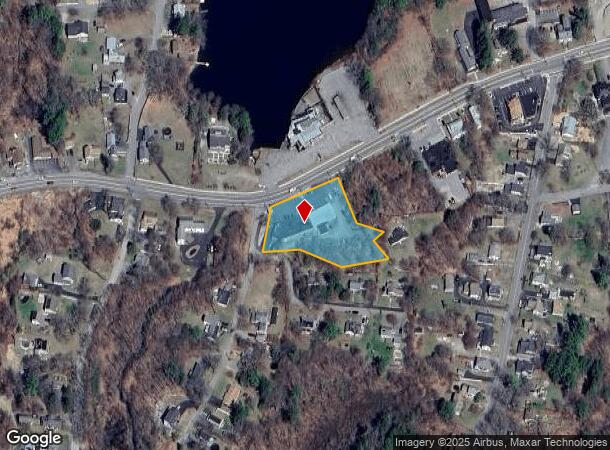
1205 Main St, Leicester, MA 01524
NEARBY LISTINGS FOR SALE OR LEASE
-
-
View all Leicester listings for lease on LoopNet.com
Property Detail
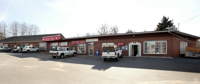
1205 Main St
Storebuilding
Worcester
X
Massachusetts
25027C0781F
1.34 AC
2025
Outlying Worcester
2025
Boston
735100
Worcester, MA-CT
8,030 SF
LEIC-000026BB000025
DEMOGRAPHICS near 1205 Main St
1 Mile
3 Mile
5 Mile
2024 Total Population
2,636
11,857
79,466
2029 Population
2,621
11,765
78,469
Pop Growth 2024-2029
(0.57%)
(0.78%)
(1.25%)
Average Age
42
42
41
2024 Total Households
979
4,480
30,558
HH Growth 2024-2029
(0.72%)
(0.83%)
(1.27%)
Median Household Inc
$77,748
$90,127
$76,546
Avg Household Size
2.50
2.60
2.40
2024 Avg HH Vehicles
2.00
2.00
2.00
Median Home Value
$345,689
$348,946
$332,620
Median Year Built
1962
1972
1953
Nearby Places
Map Layers
Map Styles
 Street
 Aerial
- Restaurants
- Banks
- Shops
- Fitness
- Groceries
PUBLIC TRANSPORTATION
COMMUTER RAIL
Worcester Union Station (Lake Shore Limited - Amtrak)
DRIVE
WALK
Distance
Worcester Union Station (Lake Shore Limited - Amtrak)
11 min
7.1 mi
Worcester (Framingham/Worcester Line - Massachusetts Bay Transportation Authority Commuter Rail (Purple Line))
DRIVE
WALK
Distance
Worcester (Framingham/Worcester Line - Massachusetts Bay Transportation Authority Commuter Rail (Purple Line))
12 min
7.3 mi
AIRPORT
Worcester Regional
DRIVE
WALK
Distance
Worcester Regional
13 min
5.7 mi
Freight Ports
Port of Boston
DRIVE
WALK
Distance
Port of Boston
72 min
52.4 mi
SALE & LEASE HISTORY
LISTING DATE
SALE/LEASE

Sep 25, 2016
For Lease
Jun 20, 2019
For Lease
Nearby Properties
Address
Land Use
TOTAL SIZE
Lot Size
Zoning
Address
Land Use
TOTAL SIZE
Lot Size
Zoning
49.08 AC
SA
Address
Land Use
TOTAL SIZE
Lot Size
Zoning
244,486 SF
42.64 AC
RL-7
Address
Land Use
TOTAL SIZE
Lot Size
Zoning
41.84 AC
Address
Land Use
TOTAL SIZE
Lot Size
Zoning
643,250 SF
35.17 AC
RL-7
Address
Land Use
TOTAL SIZE
Lot Size
Zoning
267,600 SF
45.87 AC
R2
Address
Land Use
TOTAL SIZE
Lot Size
Zoning
1,408 SF
42.06 AC
HB1
Address
Land Use
TOTAL SIZE
Lot Size
Zoning
176,000 SF
19.52 AC
RL-7
Address
Land Use
TOTAL SIZE
Lot Size
Zoning
24,000 SF
10.60 AC
SA
Address
Land Use
TOTAL SIZE
Lot Size
Zoning
206,992 SF
55.33 AC
HB1
Address
Land Use
TOTAL SIZE
Lot Size
Zoning
40 AC
B
Address
Land Use
TOTAL SIZE
Lot Size
Zoning
76,586 SF
20.44 AC
R2
Address
Land Use
TOTAL SIZE
Lot Size
Zoning
87,144 SF
12.03 AC
IP-.33
Address
Land Use
TOTAL SIZE
Lot Size
Zoning
17 AC
HB1
Address
Land Use
TOTAL SIZE
Lot Size
Zoning
175,701 SF
25.85 AC
HB2
Address
Land Use
TOTAL SIZE
Lot Size
Zoning
12.20 AC
IP-.33
Address
Land Use
TOTAL SIZE
Lot Size
Zoning
3,552 SF
13 AC
NB
Address
Land Use
TOTAL SIZE
Lot Size
Zoning
9.40 AC
HB1
Address
Land Use
TOTAL SIZE
Lot Size
Zoning
34.30 AC
RL-7
Address
Land Use
TOTAL SIZE
Lot Size
Zoning
19 AC
MG-1
Address
Land Use
TOTAL SIZE
Lot Size
Zoning
51,755 SF
5.93 AC
R1
Address
Land Use
TOTAL SIZE
Lot Size
Zoning
18,970 SF
1.91 AC
R2
Address
Land Use
TOTAL SIZE
Lot Size
Zoning
16,444 SF
0.93 AC
CB
Address
Land Use
TOTAL SIZE
Lot Size
Zoning
4.11 AC
B
Address
Land Use
TOTAL SIZE
Lot Size
Zoning
329.37 AC
HB1
Address
Land Use
TOTAL SIZE
Lot Size
Zoning
12.20 AC
RL-7
Address
Land Use
TOTAL SIZE
Lot Size
Zoning
6.86 AC
HB1
Address
Land Use
TOTAL SIZE
Lot Size
Zoning
64,040 SF
16.50 AC
A-1
Address
Land Use
TOTAL SIZE
Lot Size
Zoning
5.33 AC
A-1
Address
Land Use
TOTAL SIZE
Lot Size
Zoning
57,500 SF
4.19 AC
IP-.33
Address
Land Use
TOTAL SIZE
Lot Size
Zoning
15.38 AC
RL-7
The World's #1 Commercial Real Estate Marketplace
Connect with us
© 2025 CoStar Group
The information above has been obtained from sources believed reliable. While we do not doubt its accuracy we have not verified it and make no guarantee, warranty or representation about it. It is your responsibility to independently confirm its accuracy and completeness. Any projections, opinions, assumptions, or estimates used are for example only and do not represent the current or future performance of the property. The value of this transaction to you depends on tax and other factors which should be evaluated by your tax, financial, and legal advisors. You and your advisors should conduct a careful, independent investigation of the property to determine to your satisfaction the suitability of the property for your needs.