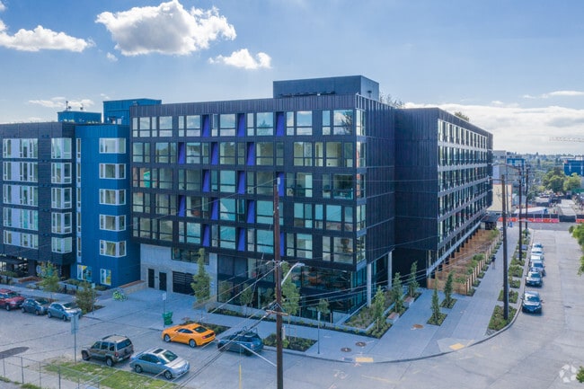
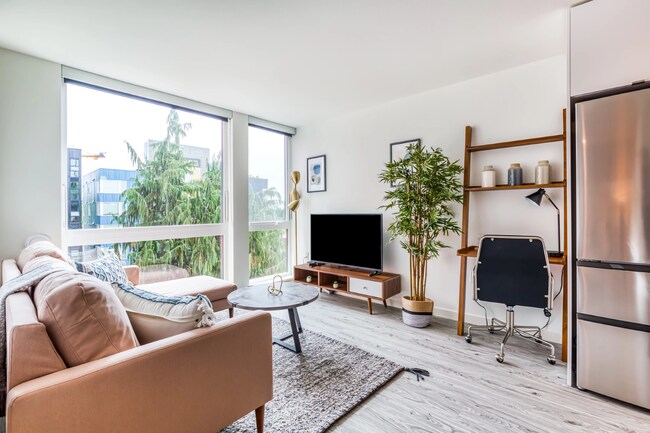
Property Record
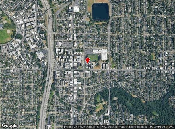
1205 Ne 66Th St, Seattle, WA 98115
NEARBY LISTINGS FOR SALE OR LEASE
Property Detail
1205 Ne 66Th St
Seattle/Puget Sound
James Div Of Green Lake Add
Seattle-Tacoma-Bellevue, WA
JAMES DIV OF GREEN LAKE ADD N 1/2 TGW N 102 FT OF S 240.35 FT OF SE 1/4 OF SE 1/4 LY W OF BROOKLYN AVE & E OF BLK 10 JAMES DIV OF GREEN LAKE ADD LESS ST POR TAXABLE PER RCW 84.14 MFTE (MULTIFAMILY TAX EXEMPTION) PROGRAM
365870-0995
King
Apartment
Washington
2025
por
2024
0.62 AC
002600
Roosevelt
111,539 SF
DEMOGRAPHICS near 1205 Ne 66Th St
1 Mile
3 Mile
5 Mile
2024 Total Population
45,544
244,774
553,013
2029 Population
46,355
247,320
560,928
Pop Growth 2024-2029
+ 1.78%
+ 1.04%
+ 1.43%
Average Age
35
37
38
2024 Total Households
20,451
108,314
270,472
HH Growth 2024-2029
+ 2.11%
+ 1.07%
+ 1.52%
Median Household Inc
$98,182
$116,546
$116,136
Avg Household Size
2.00
2.10
1.90
2024 Avg HH Vehicles
1.00
1.00
1.00
Median Home Value
$1,000,502
$951,512
$946,465
Median Year Built
1976
1969
1978
Nearby Places
Map Layers
Map Styles
 Street
 Aerial
- Restaurants
- Banks
- Shops
- Fitness
- Groceries
PUBLIC TRANSPORTATION
TRANSIT/SUBWAY
Roosevelt Station (Lynnwood - Angle Lake - Sound Transit, Northgate - Angle Lake - Sound Transit)
DRIVE
WALK
Distance
Roosevelt Station (Lynnwood - Angle Lake - Sound Transit, Northgate - Angle Lake - Sound Transit)
1 min
1 min
0.1 mi
COMMUTER RAIL
King Street (Seattle) Station (Everett - Seattle - Sound Transit, Seattle - Tacoma/Lakewood - Sound Transit, Sounder South Line - Sound Transit)
DRIVE
WALK
Distance
King Street (Seattle) Station (Everett - Seattle - Sound Transit, Seattle - Tacoma/Lakewood - Sound Transit, Sounder South Line - Sound Transit)
11 min
6.1 mi
AIRPORT
Seattle Paine Field International
DRIVE
WALK
Distance
Seattle Paine Field International
28 min
18.8 mi
Seattle-Tacoma International
DRIVE
WALK
Distance
Seattle-Tacoma International
29 min
19.3 mi
Freight Ports
Port of Seattle
DRIVE
WALK
Distance
Port of Seattle
17 min
9.8 mi
Nearby Properties
Address
Land Use
TOTAL SIZE
Lot Size
Zoning
Address
Land Use
TOTAL SIZE
Lot Size
Zoning
471.20 AC
MIO-37-LR1
Address
Land Use
TOTAL SIZE
Lot Size
Zoning
26,850 SF
194.66 AC
NR2
Address
Land Use
TOTAL SIZE
Lot Size
Zoning
107.86 AC
NR2
Address
Land Use
TOTAL SIZE
Lot Size
Zoning
50,060 SF
96.12 AC
NR2
Address
Land Use
TOTAL SIZE
Lot Size
Zoning
7,549 SF
59.34 AC
MIO-105-LR
Address
Land Use
TOTAL SIZE
Lot Size
Zoning
612,844 SF
0.09 AC
SM-U/R 75-
Address
Land Use
TOTAL SIZE
Lot Size
Zoning
90,184 SF
16.66 AC
C1-75 (M)
Address
Land Use
TOTAL SIZE
Lot Size
Zoning
107.93 AC
NR3
Address
Land Use
TOTAL SIZE
Lot Size
Zoning
42,500 SF
90.92 AC
NR3
Address
Land Use
TOTAL SIZE
Lot Size
Zoning
310,584 SF
1.18 AC
C1-55 (M)
Address
Land Use
TOTAL SIZE
Lot Size
Zoning
241,955 SF
12.81 AC
LR2 (M)
Address
Land Use
TOTAL SIZE
Lot Size
Zoning
301,245 SF
22.34 AC
LR3 (M)
Address
Land Use
TOTAL SIZE
Lot Size
Zoning
25,735 SF
1.56 AC
C1-75 (M)
Address
Land Use
TOTAL SIZE
Lot Size
Zoning
20,289 SF
10.76 AC
MIO-50-LR3
Address
Land Use
TOTAL SIZE
Lot Size
Zoning
210,103 SF
1.03 AC
NC3P-95 (M
Address
Land Use
TOTAL SIZE
Lot Size
Zoning
285,140 SF
0.90 AC
NC2-75 (M1
Address
Land Use
TOTAL SIZE
Lot Size
Zoning
131,790 SF
0.37 AC
SM-U 75-24
Address
Land Use
TOTAL SIZE
Lot Size
Zoning
6.87 AC
MIO-200-C1
Address
Land Use
TOTAL SIZE
Lot Size
Zoning
126,394 SF
8.80 AC
C2-75 (M)
Address
Land Use
TOTAL SIZE
Lot Size
Zoning
223,047 SF
0.18 AC
NC2P-75 (M
Address
Land Use
TOTAL SIZE
Lot Size
Zoning
382,762 SF
7.14 AC
NR3
Address
Land Use
TOTAL SIZE
Lot Size
Zoning
172,297 SF
4.21 AC
NC3-95 (M)
Address
Land Use
TOTAL SIZE
Lot Size
Zoning
0.31 AC
SM-U 95-32
Address
Land Use
TOTAL SIZE
Lot Size
Zoning
10,090 SF
11.73 AC
NC3-95 (M)
Address
Land Use
TOTAL SIZE
Lot Size
Zoning
132,183 SF
0.76 AC
NC2-65
Address
Land Use
TOTAL SIZE
Lot Size
Zoning
1,100 SF
18.83 AC
UI U/45
Address
Land Use
TOTAL SIZE
Lot Size
Zoning
281,306 SF
1.15 AC
C1-75 (M)
Address
Land Use
TOTAL SIZE
Lot Size
Zoning
6,534 SF
0.55 AC
IC-65 (M)
The World's #1 Commercial Real Estate Marketplace
Connect with us
© 2025 CoStar Group
The information above has been obtained from sources believed reliable. While we do not doubt its accuracy we have not verified it and make no guarantee, warranty or representation about it. It is your responsibility to independently confirm its accuracy and completeness. Any projections, opinions, assumptions, or estimates used are for example only and do not represent the current or future performance of the property. The value of this transaction to you depends on tax and other factors which should be evaluated by your tax, financial, and legal advisors. You and your advisors should conduct a careful, independent investigation of the property to determine to your satisfaction the suitability of the property for your needs.