Property Record
1205 W 5Th St, Benicia, CA 94510
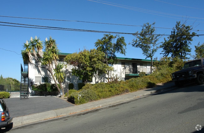

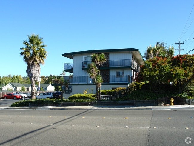

Property Detail
1205 W 5Th St
Vallejo, CA
BK-BG 00-00
0087-103-550
Solano
Multifamilydwelling
California
B and X Area of moderate flood hazard, usually the area between the limits of the 100-year and 500-year floods.
1
2025
0.77 AC
2025
Benicia
252108
North Bay/Santa Rosa
22,524 SF
NEARBY LISTINGS FOR SALE OR LEASE
DEMOGRAPHICS near 1205 W 5Th St
1 mile
3 mile
5 mile
2025 Total Population
11,701
35,415
100,721
2030 Population
11,779
35,639
101,404
Pop Growth 2025-2030
+ 0.67%
+ 0.63%
+ 0.68%
Average Age
45
45
42
2025 Total Households
5,150
14,200
38,002
HH Growth 2025-2030
+ 0.66%
+ 0.67%
+ 0.74%
Median Household Inc
$123,936
$132,639
$110,328
Avg Household Size
2.20
2.50
2.60
2025 Avg HH Vehicles
2.00
2.00
2.00
Median Home Value
$739,654
$766,031
$710,929
Median Year Built
1976
1981
1974
Nearby Places
Map Layers
Map Styles
 Street
 Aerial
Layers
 Traffic
 Biking
Places
Listings with unknown addresses are not visible on the map
- Restaurants
- Banks
- Shops
- Fitness
- Groceries
PUBLIC TRANSPORTATION
COMMUTER RAIL
Martinez (California Zephyr - Capitol Corridor Joint Powers Authority, Capitol Corridor - Capitol Corridor Joint Powers Authority, Coast Starlight - Capitol Corridor Joint Powers Authority, San Joaquins - Capitol Corridor Joint Powers Authority)
Drive
Walk
Distance
Martinez (California Zephyr - Capitol Corridor Joint Powers Authority, Capitol Corridor - Capitol Corridor Joint Powers Authority, Coast Starlight - Capitol Corridor Joint Powers Authority, San Joaquins - Capitol Corridor Joint Powers Authority)
10 min
6.4 mi
AIRPORT
Metro Oakland International
Drive
Walk
Distance
Metro Oakland International
50 min
37.8 mi
Freight Ports
Port of Richmond
Drive
Walk
Distance
Port of Richmond
35 min
24.3 mi
Nearby Properties
Address
Land Use
TOTAL SIZE
Lot Size
Zoning
Address
Land Use
TOTAL SIZE
Lot Size
Zoning
324.69 AC
Address
Land Use
TOTAL SIZE
Lot Size
Zoning
19.90 AC
Address
Land Use
TOTAL SIZE
Lot Size
Zoning
Address
Land Use
TOTAL SIZE
Lot Size
Zoning
160,000 SF
13.67 AC
Address
Land Use
TOTAL SIZE
Lot Size
Zoning
200,888 SF
19.11 AC
MR25
Address
Land Use
TOTAL SIZE
Lot Size
Zoning
22,176 SF
15.14 AC
Address
Land Use
TOTAL SIZE
Lot Size
Zoning
243,000 SF
12.62 AC
Address
Land Use
TOTAL SIZE
Lot Size
Zoning
86,222 SF
39.83 AC
Address
Land Use
TOTAL SIZE
Lot Size
Zoning
12.63 AC
Address
Land Use
TOTAL SIZE
Lot Size
Zoning
19.08 AC
Address
Land Use
TOTAL SIZE
Lot Size
Zoning
13.63 AC
Address
Land Use
TOTAL SIZE
Lot Size
Zoning
488,220 SF
11.88 AC
Address
Land Use
TOTAL SIZE
Lot Size
Zoning
240,000 SF
11.77 AC
Address
Land Use
TOTAL SIZE
Lot Size
Zoning
240,000 SF
9.60 AC
INDUSTRIAL
Address
Land Use
TOTAL SIZE
Lot Size
Zoning
12.80 AC
Address
Land Use
TOTAL SIZE
Lot Size
Zoning
115,292 SF
9.85 AC
Address
Land Use
TOTAL SIZE
Lot Size
Zoning
100,547 SF
7.51 AC
Address
Land Use
TOTAL SIZE
Lot Size
Zoning
120,000 SF
5.52 AC
Address
Land Use
TOTAL SIZE
Lot Size
Zoning
15,032 SF
47.47 AC
Address
Land Use
TOTAL SIZE
Lot Size
Zoning
1,536,263 SF
6.57 AC
Address
Land Use
TOTAL SIZE
Lot Size
Zoning
77,841 SF
7.67 AC
Address
Land Use
TOTAL SIZE
Lot Size
Zoning
142,020 SF
7.80 AC
Address
Land Use
TOTAL SIZE
Lot Size
Zoning
3.75 AC
RM
Address
Land Use
TOTAL SIZE
Lot Size
Zoning
1,536,263 SF
9.65 AC
Address
Land Use
TOTAL SIZE
Lot Size
Zoning
220,000 SF
9.33 AC
Address
Land Use
TOTAL SIZE
Lot Size
Zoning
21,410 SF
19.35 AC
Address
Land Use
TOTAL SIZE
Lot Size
Zoning
1,536,263 SF
6 AC
Address
Land Use
TOTAL SIZE
Lot Size
Zoning
82,040 SF
8.22 AC
INDUSTRIAL
Address
Land Use
TOTAL SIZE
Lot Size
Zoning
35,434 SF
1.66 AC
Address
Land Use
TOTAL SIZE
Lot Size
Zoning
5.17 AC
INDUSTRIAL
The World's #1 Commercial Real Estate Marketplace
Connect with us
© 2026 CoStar Group
The information above has been obtained from sources believed reliable. While we do not doubt its accuracy we have not verified it and make no guarantee, warranty or representation about it. It is your responsibility to independently confirm its accuracy and completeness. Any projections, opinions, assumptions, or estimates used are for example only and do not represent the current or future performance of the property. The value of this transaction to you depends on tax and other factors which should be evaluated by your tax, financial, and legal advisors. You and your advisors should conduct a careful, independent investigation of the property to determine to your satisfaction the suitability of the property for your needs.