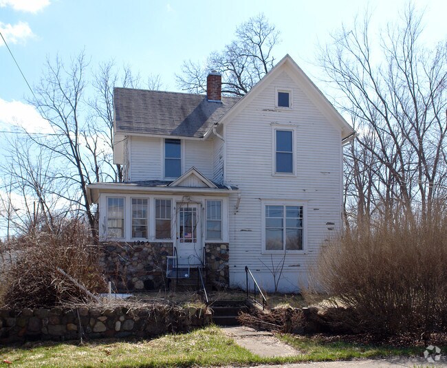
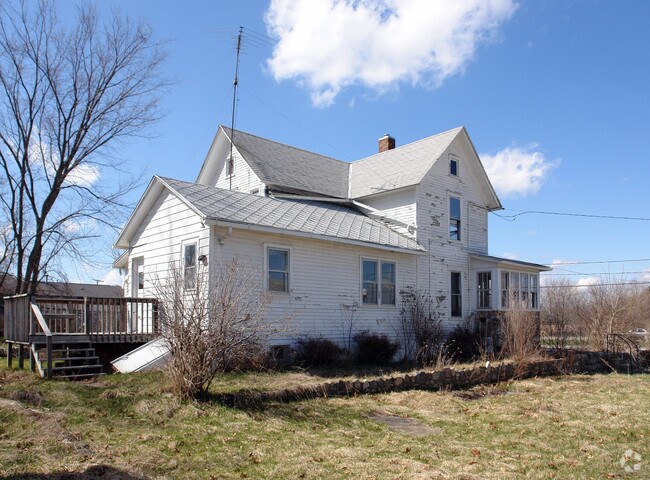
Property Record
1205 W Dickman Rd, Springfield, MI 49037
NEARBY LISTINGS FOR SALE OR LEASE
Property Detail
1205 W Dickman Rd
0052-00-027-0
SEC 2 T2S R8W BEG AT PT ON S LI OF SD SEC DIST 57.75 FT E OF S 1/4 POST - N 00 DEG 30 MIN W 130.48 FT - S 89 DEG 41 MIN E ALG
Supermarket
Calhoun
X
Michigan
26025C0179C
0.33 AC
0
Battle Crk/W Calhoun Cnty
2025
West Michigan
001300
Battle Creek, MI
2,960 SF
DEMOGRAPHICS near 1205 W Dickman Rd
1 mile
3 mile
5 mile
2024 Total Population
7,754
51,223
76,568
2029 Population
7,729
50,808
75,843
Pop Growth 2024-2029
(0.32%)
(0.81%)
(0.95%)
Average Age
37
39
39
2024 Total Households
3,028
20,770
31,356
HH Growth 2024-2029
(0.43%)
(0.87%)
(0.97%)
Median Household Inc
$37,568
$44,776
$48,906
Avg Household Size
2.40
2.40
2.30
2024 Avg HH Vehicles
1.00
2.00
2.00
Median Home Value
$65,962
$90,917
$117,252
Median Year Built
1949
1953
1958
Nearby Places
Map Layers
Map Styles
 Street
 Aerial
Transit
 Traffic
 Biking
Places
Listings with unknown addresses are not visible on the map
- Restaurants
- Banks
- Shops
- Fitness
- Groceries
PUBLIC TRANSPORTATION
COMMUTER RAIL
Battle Creek (Blue Water - Amtrak, Wolverine - Amtrak)
Drive
Walk
Distance
Battle Creek (Blue Water - Amtrak, Wolverine - Amtrak)
3 min
1.3 mi
AIRPORT
Kalamazoo/Battle Creek International
Drive
Walk
Distance
Kalamazoo/Battle Creek International
34 min
22.7 mi
Freight Ports
Port of Toledo
Drive
Walk
Distance
Port of Toledo
153 min
124.2 mi
Nearby Properties
Address
Land Use
TOTAL SIZE
Lot Size
Zoning
Address
Land Use
TOTAL SIZE
Lot Size
Zoning
337,297 SF
18.85 AC
T4
Address
Land Use
TOTAL SIZE
Lot Size
Zoning
291,206 SF
18.98 AC
T4
Address
Land Use
TOTAL SIZE
Lot Size
Zoning
1,131,895 SF
26.46 AC
I1
Address
Land Use
TOTAL SIZE
Lot Size
Zoning
158,242 SF
28.01 AC
B1
Address
Land Use
TOTAL SIZE
Lot Size
Zoning
174,064 SF
T4
Address
Land Use
TOTAL SIZE
Lot Size
Zoning
52,764 SF
3.52 AC
AG
Address
Land Use
TOTAL SIZE
Lot Size
Zoning
131,048 SF
12.28 AC
R1A
Address
Land Use
TOTAL SIZE
Lot Size
Zoning
111,002 SF
AG
Address
Land Use
TOTAL SIZE
Lot Size
Zoning
134,482 SF
17.15 AC
MFR
Address
Land Use
TOTAL SIZE
Lot Size
Zoning
93,223 SF
34.81 AC
MFR
Address
Land Use
TOTAL SIZE
Lot Size
Zoning
158,242 SF
25.25 AC
B1
Address
Land Use
TOTAL SIZE
Lot Size
Zoning
134,355 SF
5.35 AC
MFR
Address
Land Use
TOTAL SIZE
Lot Size
Zoning
150,018 SF
13.12 AC
MFR
Address
Land Use
TOTAL SIZE
Lot Size
Zoning
129,598 SF
0.62 AC
T5
Address
Land Use
TOTAL SIZE
Lot Size
Zoning
113,070 SF
6.35 AC
MFR
Address
Land Use
TOTAL SIZE
Lot Size
Zoning
34,452 SF
1.12 AC
T4
Address
Land Use
TOTAL SIZE
Lot Size
Zoning
65,362 SF
5.04 AC
MFR
Address
Land Use
TOTAL SIZE
Lot Size
Zoning
96,142 SF
13.73 AC
MFR
Address
Land Use
TOTAL SIZE
Lot Size
Zoning
106,703 SF
9.69 AC
MFR
Address
Land Use
TOTAL SIZE
Lot Size
Zoning
57,235 SF
15.54 AC
R1A
Address
Land Use
TOTAL SIZE
Lot Size
Zoning
49,412 SF
Address
Land Use
TOTAL SIZE
Lot Size
Zoning
50,812 SF
14.12 AC
MFR
Address
Land Use
TOTAL SIZE
Lot Size
Zoning
44,744 SF
8.54 AC
MFR
Address
Land Use
TOTAL SIZE
Lot Size
Zoning
55,819 SF
15.38 AC
R1A
Address
Land Use
TOTAL SIZE
Lot Size
Zoning
188,388 SF
18.15 AC
T3
Address
Land Use
TOTAL SIZE
Lot Size
Zoning
111,744 SF
9.75 AC
RM-1
Address
Land Use
TOTAL SIZE
Lot Size
Zoning
95,666 SF
46.56 AC
I1
Address
Land Use
TOTAL SIZE
Lot Size
Zoning
56,658 SF
4.89 AC
MFR
Address
Land Use
TOTAL SIZE
Lot Size
Zoning
53,501 SF
7.34 AC
B1
Address
Land Use
TOTAL SIZE
Lot Size
Zoning
98,360 SF
0.31 AC
T5
The World's #1 Commercial Real Estate Marketplace
Connect with us
© 2026 CoStar Group
The information above has been obtained from sources believed reliable. While we do not doubt its accuracy we have not verified it and make no guarantee, warranty or representation about it. It is your responsibility to independently confirm its accuracy and completeness. Any projections, opinions, assumptions, or estimates used are for example only and do not represent the current or future performance of the property. The value of this transaction to you depends on tax and other factors which should be evaluated by your tax, financial, and legal advisors. You and your advisors should conduct a careful, independent investigation of the property to determine to your satisfaction the suitability of the property for your needs.