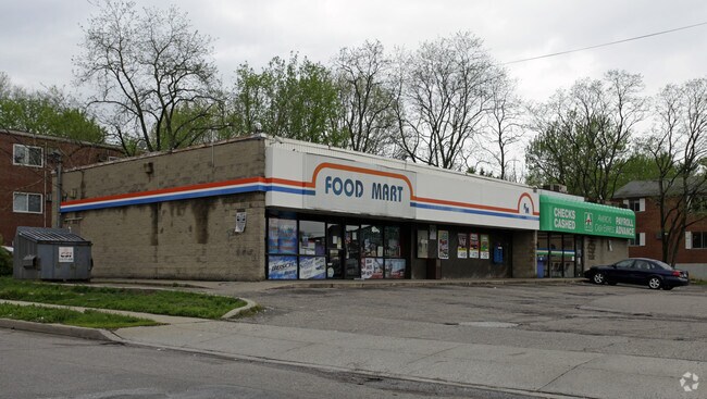
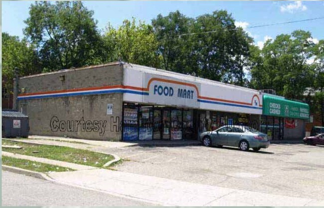
Property Record
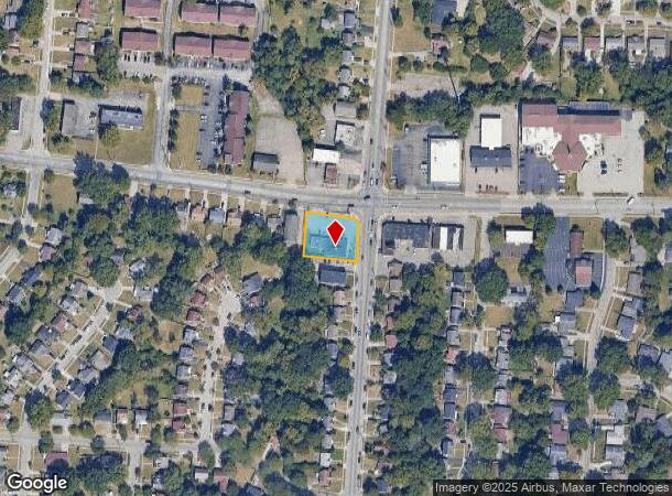
1205 W Galbraith Rd, Cincinnati, OH 45231
NEARBY LISTINGS FOR SALE OR LEASE
Property Detail
1205 W Galbraith Rd
247-0005-0310
Benson Tract Subdivision #2
Storebuilding
SW COR GALBRAITH-DALY RDS0.407 AC R1 T3 S25
X
Hamilton
39061C0208E
Ohio
2024
0.41 AC
2024
Forest Park/West
011100
Cincinnati/Dayton
3,537 SF
Cincinnati, OH-KY-IN
DEMOGRAPHICS near 1205 W Galbraith Rd
1 Mile
3 Mile
5 Mile
2024 Total Population
13,779
88,316
228,569
2029 Population
13,549
87,514
226,146
Pop Growth 2024-2029
(1.67%)
(0.91%)
(1.06%)
Average Age
40
40
40
2024 Total Households
5,476
36,057
95,280
HH Growth 2024-2029
(1.83%)
(1.04%)
(1.18%)
Median Household Inc
$60,707
$51,913
$54,762
Avg Household Size
2.40
2.30
2.30
2024 Avg HH Vehicles
2.00
2.00
2.00
Median Home Value
$151,085
$151,948
$159,846
Median Year Built
1958
1959
1959
Nearby Places
Map Layers
Map Styles
 Street
 Aerial
- Restaurants
- Banks
- Shops
- Fitness
- Groceries
PUBLIC TRANSPORTATION
AIRPORT
Cincinnati/Northern Kentucky International
DRIVE
WALK
Distance
Cincinnati/Northern Kentucky International
43 min
24.2 mi
Freight Ports
Port of Toledo
DRIVE
WALK
Distance
Port of Toledo
234 min
200.1 mi
Nearby Properties
Address
Land Use
TOTAL SIZE
Lot Size
Zoning
Address
Land Use
TOTAL SIZE
Lot Size
Zoning
26.16 AC
Address
Land Use
TOTAL SIZE
Lot Size
Zoning
2.49 AC
DD
Address
Land Use
TOTAL SIZE
Lot Size
Zoning
112.35 AC
RM20
Address
Land Use
TOTAL SIZE
Lot Size
Zoning
Address
Land Use
TOTAL SIZE
Lot Size
Zoning
11,639 SF
7.87 AC
R2
Address
Land Use
TOTAL SIZE
Lot Size
Zoning
60.86 AC
Address
Land Use
TOTAL SIZE
Lot Size
Zoning
24.69 AC
Address
Land Use
TOTAL SIZE
Lot Size
Zoning
42.41 AC
Address
Land Use
TOTAL SIZE
Lot Size
Zoning
344,923 SF
18.47 AC
RM20
Address
Land Use
TOTAL SIZE
Lot Size
Zoning
13.08 AC
Address
Land Use
TOTAL SIZE
Lot Size
Zoning
20.07 AC
B2
Address
Land Use
TOTAL SIZE
Lot Size
Zoning
41,564 SF
13.21 AC
Address
Land Use
TOTAL SIZE
Lot Size
Zoning
88.15 AC
ML
Address
Land Use
TOTAL SIZE
Lot Size
Zoning
11,664 SF
29.27 AC
RM20
Address
Land Use
TOTAL SIZE
Lot Size
Zoning
103.18 AC
R1A
Address
Land Use
TOTAL SIZE
Lot Size
Zoning
50.02 AC
Address
Land Use
TOTAL SIZE
Lot Size
Zoning
8,720 SF
33.28 AC
R3
Address
Land Use
TOTAL SIZE
Lot Size
Zoning
60,614 SF
13.35 AC
SF6
Address
Land Use
TOTAL SIZE
Lot Size
Zoning
Address
Land Use
TOTAL SIZE
Lot Size
Zoning
4,800 SF
7.20 AC
Address
Land Use
TOTAL SIZE
Lot Size
Zoning
2,400 SF
0.35 AC
R1
Address
Land Use
TOTAL SIZE
Lot Size
Zoning
121,747 SF
23.05 AC
R3
Address
Land Use
TOTAL SIZE
Lot Size
Zoning
Address
Land Use
TOTAL SIZE
Lot Size
Zoning
28.25 AC
Address
Land Use
TOTAL SIZE
Lot Size
Zoning
1,860 SF
12.01 AC
A2
Address
Land Use
TOTAL SIZE
Lot Size
Zoning
20.33 AC
SF6
Address
Land Use
TOTAL SIZE
Lot Size
Zoning
50,196 SF
17.64 AC
RM20
Address
Land Use
TOTAL SIZE
Lot Size
Zoning
49,056 SF
5.70 AC
RM20
Address
Land Use
TOTAL SIZE
Lot Size
Zoning
Address
Land Use
TOTAL SIZE
Lot Size
Zoning
The World's #1 Commercial Real Estate Marketplace
Connect with us
© 2025 CoStar Group
The information above has been obtained from sources believed reliable. While we do not doubt its accuracy we have not verified it and make no guarantee, warranty or representation about it. It is your responsibility to independently confirm its accuracy and completeness. Any projections, opinions, assumptions, or estimates used are for example only and do not represent the current or future performance of the property. The value of this transaction to you depends on tax and other factors which should be evaluated by your tax, financial, and legal advisors. You and your advisors should conduct a careful, independent investigation of the property to determine to your satisfaction the suitability of the property for your needs.