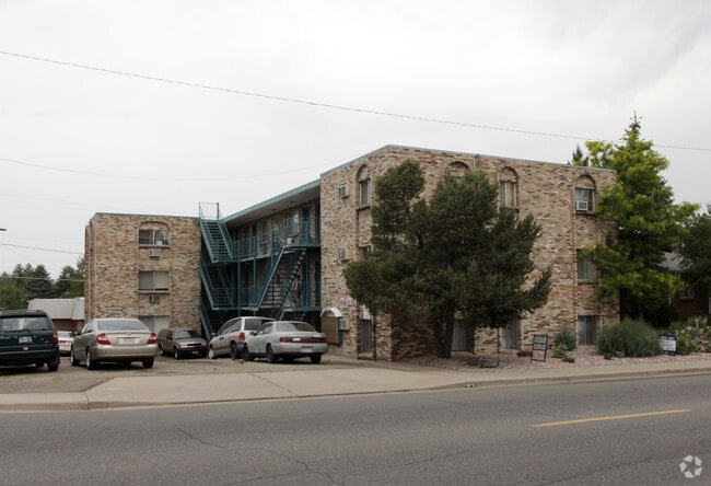
Property Record
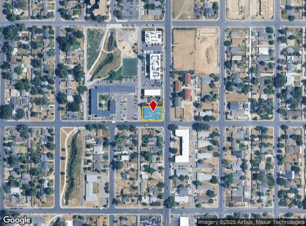
1205 Yosemite St, Denver, CO 80220

This Property Is For Sale
NEARBY LISTINGS FOR SALE OR LEASE
Property Detail
1205 Yosemite St
Denver-Aurora-Lakewood, CO
Burns Montclair
6041-17-004
BURNS MONTCLAIR B1 L12 TO 14
Apartment
Denver
X
Colorado
0800460207H
12-14
2024
0.23 AC
2024
East Colfax
004404
Denver
11,052 SF
DEMOGRAPHICS near 1205 Yosemite St
1 Mile
3 Mile
5 Mile
2024 Total Population
25,848
182,982
470,894
2029 Population
26,337
185,835
477,336
Pop Growth 2024-2029
+ 1.89%
+ 1.56%
+ 1.37%
Average Age
35
38
38
2024 Total Households
9,619
73,154
197,727
HH Growth 2024-2029
+ 1.85%
+ 1.51%
+ 1.32%
Median Household Inc
$57,387
$70,867
$72,998
Avg Household Size
2.60
2.40
2.30
2024 Avg HH Vehicles
1.00
2.00
2.00
Median Home Value
$418,182
$542,793
$512,668
Median Year Built
1970
1973
1976
Nearby Places
Map Layers
Map Styles
 Street
 Aerial
- Restaurants
- Banks
- Shops
- Fitness
- Groceries
PUBLIC TRANSPORTATION
COMMUTER RAIL
DRIVE
WALK
Distance
7 min
2.9 mi
DRIVE
WALK
Distance
7 min
2.9 mi
AIRPORT
Denver International
DRIVE
WALK
Distance
Denver International
28 min
19.1 mi
Nearby Properties
Address
Land Use
TOTAL SIZE
Lot Size
Zoning
Address
Land Use
TOTAL SIZE
Lot Size
Zoning
368,450 SF
48.59 AC
Address
Land Use
TOTAL SIZE
Lot Size
Zoning
353,829 SF
4.51 AC
Address
Land Use
TOTAL SIZE
Lot Size
Zoning
719,357 SF
21.47 AC
M-MX-5
Address
Land Use
TOTAL SIZE
Lot Size
Zoning
880,442 SF
67.95 AC
I-B
Address
Land Use
TOTAL SIZE
Lot Size
Zoning
525,050 SF
105.06 AC
Address
Land Use
TOTAL SIZE
Lot Size
Zoning
603,377 SF
9.25 AC
H-1-A
Address
Land Use
TOTAL SIZE
Lot Size
Zoning
254,509 SF
16.29 AC
E-SU-DX
Address
Land Use
TOTAL SIZE
Lot Size
Zoning
191,192 SF
10.16 AC
E-SU-D
Address
Land Use
TOTAL SIZE
Lot Size
Zoning
273,184 SF
1.89 AC
Address
Land Use
TOTAL SIZE
Lot Size
Zoning
390,822 SF
13.47 AC
O-1
Address
Land Use
TOTAL SIZE
Lot Size
Zoning
185,206 SF
9.94 AC
C-MX
Address
Land Use
TOTAL SIZE
Lot Size
Zoning
167,621 SF
6.59 AC
E-SU-D
Address
Land Use
TOTAL SIZE
Lot Size
Zoning
646,975 SF
32.60 AC
M-IMX-8
Address
Land Use
TOTAL SIZE
Lot Size
Zoning
33.01 AC
M-IMX-12
Address
Land Use
TOTAL SIZE
Lot Size
Zoning
269,622 SF
12.90 AC
Address
Land Use
TOTAL SIZE
Lot Size
Zoning
253,099 SF
7.15 AC
E-SU-DX
Address
Land Use
TOTAL SIZE
Lot Size
Zoning
343,997 SF
6.36 AC
S-MX-5
Address
Land Use
TOTAL SIZE
Lot Size
Zoning
672,521 SF
0.61 AC
RB3
Address
Land Use
TOTAL SIZE
Lot Size
Zoning
384,886 SF
18.66 AC
R-2-A
Address
Land Use
TOTAL SIZE
Lot Size
Zoning
677,018 SF
5.05 AC
C-MX
Address
Land Use
TOTAL SIZE
Lot Size
Zoning
178,235 SF
1.38 AC
RFBAD
Address
Land Use
TOTAL SIZE
Lot Size
Zoning
295,885 SF
6.05 AC
R-MU-30
Address
Land Use
TOTAL SIZE
Lot Size
Zoning
89,205 SF
6.83 AC
E-SU-DX
Address
Land Use
TOTAL SIZE
Lot Size
Zoning
384,124 SF
3.25 AC
S-MX-12
Address
Land Use
TOTAL SIZE
Lot Size
Zoning
380,376 SF
24.52 AC
E-SU-DX
Address
Land Use
TOTAL SIZE
Lot Size
Zoning
368,676 SF
17.71 AC
R-2-A
Address
Land Use
TOTAL SIZE
Lot Size
Zoning
540,380 SF
26.03 AC
RR3
Address
Land Use
TOTAL SIZE
Lot Size
Zoning
466,055 SF
24.82 AC
M-IMX-5
Address
Land Use
TOTAL SIZE
Lot Size
Zoning
551,531 SF
5.09 AC
C-MX
Address
Land Use
TOTAL SIZE
Lot Size
Zoning
111,358 SF
1.21 AC
The World's #1 Commercial Real Estate Marketplace
Connect with us
© 2025 CoStar Group
The information above has been obtained from sources believed reliable. While we do not doubt its accuracy we have not verified it and make no guarantee, warranty or representation about it. It is your responsibility to independently confirm its accuracy and completeness. Any projections, opinions, assumptions, or estimates used are for example only and do not represent the current or future performance of the property. The value of this transaction to you depends on tax and other factors which should be evaluated by your tax, financial, and legal advisors. You and your advisors should conduct a careful, independent investigation of the property to determine to your satisfaction the suitability of the property for your needs.