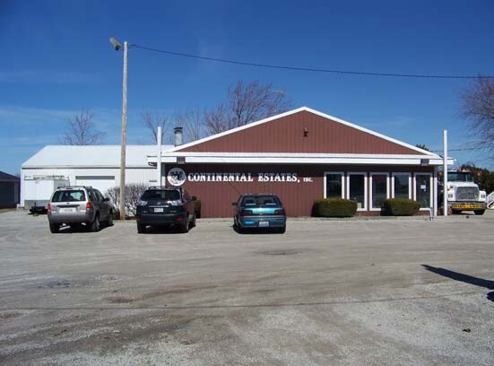
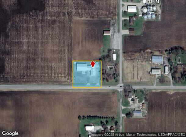
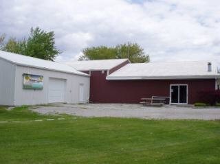
Property Record
12052 Us Highway 20A, Wauseon, OH 43567
NEARBY LISTINGS FOR SALE OR LEASE
Property Detail
12052 Us Highway 20A
30-057456-02.001
7E-7N-7 W 273FT E 466.69FT S 255FT SE 1.60A
Commercialnec
Fulton
X
Ohio
39051C0205D
1.60 AC
2024
Fulton County
2024
Toledo
040500
Toledo, OH
5,560 SF
DEMOGRAPHICS near 12052 Us Highway 20A
1 Mile
3 Mile
5 Mile
2024 Total Population
103
6,853
14,464
2029 Population
99
6,810
14,369
Pop Growth 2024-2029
(3.88%)
(0.63%)
(0.66%)
Average Age
40
40
40
2024 Total Households
36
2,751
5,731
HH Growth 2024-2029
(2.78%)
(0.65%)
(0.65%)
Median Household Inc
$106,250
$62,384
$65,211
Avg Household Size
2.80
2.40
2.50
2024 Avg HH Vehicles
3.00
2.00
2.00
Median Home Value
$221,428
$173,866
$164,983
Median Year Built
1961
1974
1973
Nearby Places
Map Layers
Map Styles
 Street
 Aerial
- Restaurants
- Banks
- Shops
- Fitness
- Groceries
PUBLIC TRANSPORTATION
AIRPORT
Eugene F Kranz Toledo Express
DRIVE
WALK
Distance
Eugene F Kranz Toledo Express
30 min
16.2 mi
Freight Ports
Port of Toledo
DRIVE
WALK
Distance
Port of Toledo
59 min
35.8 mi
Nearby Properties
Address
Land Use
TOTAL SIZE
Lot Size
Zoning
Address
Land Use
TOTAL SIZE
Lot Size
Zoning
70,940 SF
437.83 AC
M2
Address
Land Use
TOTAL SIZE
Lot Size
Zoning
137,265 SF
40 AC
R1
Address
Land Use
TOTAL SIZE
Lot Size
Zoning
2,408 SF
158.45 AC
M3
Address
Land Use
TOTAL SIZE
Lot Size
Zoning
137,965 SF
43.86 AC
R1
Address
Land Use
TOTAL SIZE
Lot Size
Zoning
170,800 SF
39.11 AC
M2
Address
Land Use
TOTAL SIZE
Lot Size
Zoning
14,000 SF
259.90 AC
M2
Address
Land Use
TOTAL SIZE
Lot Size
Zoning
215,270 SF
23.63 AC
B2
Address
Land Use
TOTAL SIZE
Lot Size
Zoning
71,038 SF
20 AC
R2
Address
Land Use
TOTAL SIZE
Lot Size
Zoning
25,036 SF
11.40 AC
Address
Land Use
TOTAL SIZE
Lot Size
Zoning
36,080 SF
17.32 AC
Address
Land Use
TOTAL SIZE
Lot Size
Zoning
26,670 SF
6.50 AC
Address
Land Use
TOTAL SIZE
Lot Size
Zoning
63,600 SF
14.82 AC
Address
Land Use
TOTAL SIZE
Lot Size
Zoning
5.47 AC
Address
Land Use
TOTAL SIZE
Lot Size
Zoning
29,950 SF
1.21 AC
B3
Address
Land Use
TOTAL SIZE
Lot Size
Zoning
13,636 SF
1.93 AC
Address
Land Use
TOTAL SIZE
Lot Size
Zoning
24,168 SF
0.08 AC
Address
Land Use
TOTAL SIZE
Lot Size
Zoning
1,620 SF
148.45 AC
M3
Address
Land Use
TOTAL SIZE
Lot Size
Zoning
58,392 SF
5.96 AC
B2
Address
Land Use
TOTAL SIZE
Lot Size
Zoning
1,286 SF
219.30 AC
Address
Land Use
TOTAL SIZE
Lot Size
Zoning
320.38 AC
Address
Land Use
TOTAL SIZE
Lot Size
Zoning
2,144 SF
230 AC
Address
Land Use
TOTAL SIZE
Lot Size
Zoning
3,456 SF
5 AC
R4
Address
Land Use
TOTAL SIZE
Lot Size
Zoning
16,926 SF
10 AC
B2
Address
Land Use
TOTAL SIZE
Lot Size
Zoning
42,789 SF
2.45 AC
B2
Address
Land Use
TOTAL SIZE
Lot Size
Zoning
6,000 SF
116.86 AC
R2
Address
Land Use
TOTAL SIZE
Lot Size
Zoning
14,414 SF
2 AC
B2
Address
Land Use
TOTAL SIZE
Lot Size
Zoning
2,640 SF
136.90 AC
Address
Land Use
TOTAL SIZE
Lot Size
Zoning
19,035 SF
0.74 AC
B3
Address
Land Use
TOTAL SIZE
Lot Size
Zoning
176.90 AC
Address
Land Use
TOTAL SIZE
Lot Size
Zoning
4,480 SF
2.37 AC
The World's #1 Commercial Real Estate Marketplace
Connect with us
© 2025 CoStar Group
The information above has been obtained from sources believed reliable. While we do not doubt its accuracy we have not verified it and make no guarantee, warranty or representation about it. It is your responsibility to independently confirm its accuracy and completeness. Any projections, opinions, assumptions, or estimates used are for example only and do not represent the current or future performance of the property. The value of this transaction to you depends on tax and other factors which should be evaluated by your tax, financial, and legal advisors. You and your advisors should conduct a careful, independent investigation of the property to determine to your satisfaction the suitability of the property for your needs.