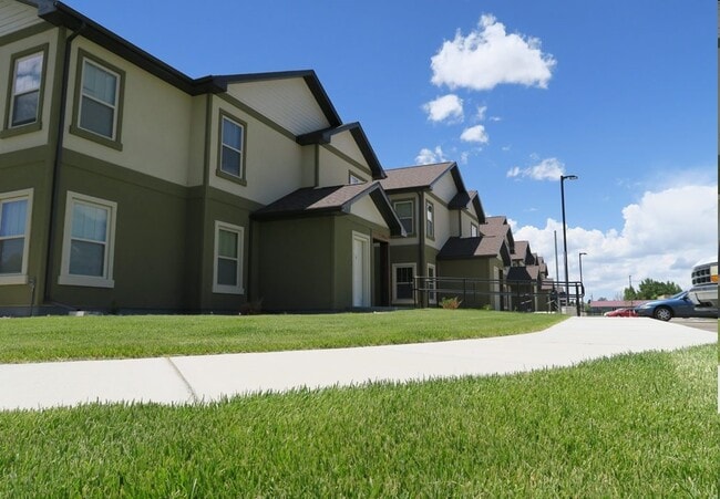
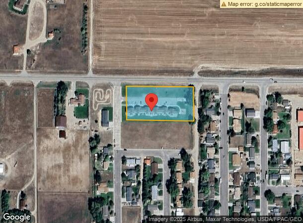
Property Record
1206 22Nd St, Wheatland, WY 82201
NEARBY LISTINGS FOR SALE OR LEASE
-
-
View all Wheatland listings for sale on LoopNet.com
Property Detail
1206 22Nd St
Other Market Areas
Gunter Addition
R0003360
TOWN OF WHEATLAND, GUNTER ADDITION, PART OF LOT 42 AND ALL OF LOT 43 (PARCEL A REVISED)
Apartmenthouse5plusunits
Platte
2025
Wyoming
2025
41,43
959401
1.81 AC
14,953 SF
I-25 Corridor/Casper
DEMOGRAPHICS near 1206 22Nd St
1 Mile
3 Mile
5 Mile
2024 Total Population
3,081
5,338
5,912
2029 Population
3,238
5,599
6,190
Pop Growth 2024-2029
+ 5.10%
+ 4.89%
+ 4.70%
Average Age
44
44
44
2024 Total Households
1,363
2,334
2,581
HH Growth 2024-2029
+ 5.43%
+ 5.06%
+ 4.88%
Median Household Inc
$59,756
$62,096
$60,656
Avg Household Size
2.20
2.20
2.20
2024 Avg HH Vehicles
2.00
2.00
2.00
Median Home Value
$181,627
$226,703
$234,698
Median Year Built
1972
1975
1975
Nearby Places
Map Layers
Map Styles
 Street
 Aerial
- Restaurants
- Banks
- Shops
- Fitness
- Groceries
Nearby Properties
Address
Land Use
TOTAL SIZE
Lot Size
Zoning
Address
Land Use
TOTAL SIZE
Lot Size
Zoning
37,368 SF
2.43 AC
Address
Land Use
TOTAL SIZE
Lot Size
Zoning
28,254 SF
1.85 AC
Address
Land Use
TOTAL SIZE
Lot Size
Zoning
19,248 SF
2.54 AC
Address
Land Use
TOTAL SIZE
Lot Size
Zoning
51,771 SF
3.65 AC
Address
Land Use
TOTAL SIZE
Lot Size
Zoning
4,288 SF
3.63 AC
Address
Land Use
TOTAL SIZE
Lot Size
Zoning
5,933 SF
0.70 AC
Address
Land Use
TOTAL SIZE
Lot Size
Zoning
26,242 SF
3.39 AC
Address
Land Use
TOTAL SIZE
Lot Size
Zoning
12,673 SF
2.46 AC
Address
Land Use
TOTAL SIZE
Lot Size
Zoning
12,856 SF
1.34 AC
Address
Land Use
TOTAL SIZE
Lot Size
Zoning
14,382 SF
2.33 AC
Address
Land Use
TOTAL SIZE
Lot Size
Zoning
35,197 SF
3.22 AC
Address
Land Use
TOTAL SIZE
Lot Size
Zoning
18,300 SF
3.85 AC
Address
Land Use
TOTAL SIZE
Lot Size
Zoning
6,944 SF
1.09 AC
Address
Land Use
TOTAL SIZE
Lot Size
Zoning
2,190 SF
3 AC
Address
Land Use
TOTAL SIZE
Lot Size
Zoning
6,407 SF
0.80 AC
Address
Land Use
TOTAL SIZE
Lot Size
Zoning
8,400 SF
4.50 AC
Address
Land Use
TOTAL SIZE
Lot Size
Zoning
6,782 SF
1.66 AC
Address
Land Use
TOTAL SIZE
Lot Size
Zoning
4,334 SF
0.57 AC
Address
Land Use
TOTAL SIZE
Lot Size
Zoning
10,032 SF
0.48 AC
Address
Land Use
TOTAL SIZE
Lot Size
Zoning
20,210 SF
8.06 AC
Address
Land Use
TOTAL SIZE
Lot Size
Zoning
9,476 SF
0.80 AC
Address
Land Use
TOTAL SIZE
Lot Size
Zoning
6,562 SF
2.66 AC
Address
Land Use
TOTAL SIZE
Lot Size
Zoning
9,606 SF
0.40 AC
Address
Land Use
TOTAL SIZE
Lot Size
Zoning
15,372 SF
1.33 AC
Address
Land Use
TOTAL SIZE
Lot Size
Zoning
21,237 SF
1.26 AC
Address
Land Use
TOTAL SIZE
Lot Size
Zoning
3,220 SF
0.80 AC
Address
Land Use
TOTAL SIZE
Lot Size
Zoning
6,040 SF
7.89 AC
Address
Land Use
TOTAL SIZE
Lot Size
Zoning
5,446 SF
2.65 AC
Address
Land Use
TOTAL SIZE
Lot Size
Zoning
7,008 SF
3.91 AC
Address
Land Use
TOTAL SIZE
Lot Size
Zoning
7,301 SF
0.26 AC
The World's #1 Commercial Real Estate Marketplace
Connect with us
© 2025 CoStar Group
The information above has been obtained from sources believed reliable. While we do not doubt its accuracy we have not verified it and make no guarantee, warranty or representation about it. It is your responsibility to independently confirm its accuracy and completeness. Any projections, opinions, assumptions, or estimates used are for example only and do not represent the current or future performance of the property. The value of this transaction to you depends on tax and other factors which should be evaluated by your tax, financial, and legal advisors. You and your advisors should conduct a careful, independent investigation of the property to determine to your satisfaction the suitability of the property for your needs.