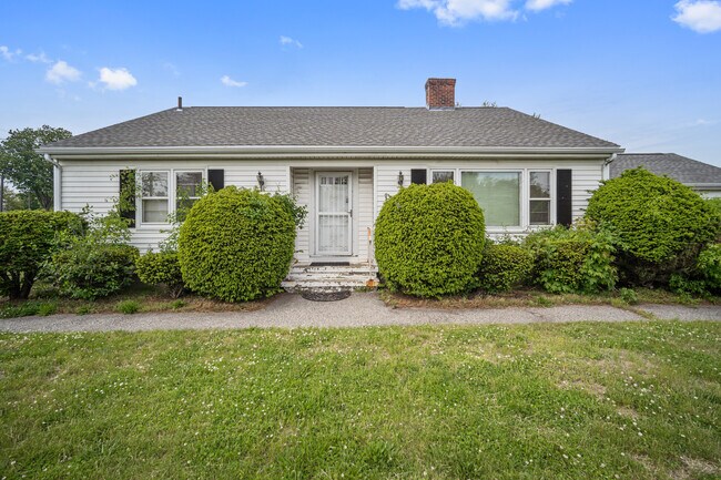
Property Record
1206 Boston Rd, Springfield, MA 01119

NEARBY LISTINGS FOR SALE OR LEASE
Property Detail
1206 Boston Rd
Officebuilding
Hampden
X
Massachusetts
25013C0219E
0.24 AC
2025
Hampden County
2025
Hartford
801503
Springfield, MA
1,779 SF
SPRI-001655-000000-000225
DEMOGRAPHICS near 1206 Boston Rd
1 Mile
3 Mile
5 Mile
2024 Total Population
11,282
66,201
197,319
2029 Population
11,108
65,272
193,968
Pop Growth 2024-2029
(1.54%)
(1.40%)
(1.70%)
Average Age
38
41
39
2024 Total Households
4,453
25,936
75,836
HH Growth 2024-2029
(1.62%)
(1.47%)
(1.73%)
Median Household Inc
$48,815
$63,322
$56,323
Avg Household Size
2.50
2.40
2.40
2024 Avg HH Vehicles
1.00
2.00
2.00
Median Home Value
$195,263
$224,562
$230,943
Median Year Built
1962
1959
1954
Nearby Places
Map Layers
Map Styles
 Street
 Aerial
- Restaurants
- Banks
- Shops
- Fitness
- Groceries
PUBLIC TRANSPORTATION
COMMUTER RAIL
DRIVE
WALK
Distance
11 min
5.9 mi
DRIVE
WALK
Distance
16 min
9.3 mi
AIRPORT
Bradley International
DRIVE
WALK
Distance
Bradley International
41 min
19.2 mi
Worcester Regional
DRIVE
WALK
Distance
Worcester Regional
68 min
46.8 mi
SALE & LEASE HISTORY
LISTING DATE
SALE/LEASE

May 23, 2022
For Sale
Nearby Properties
Address
Land Use
TOTAL SIZE
Lot Size
Zoning
Address
Land Use
TOTAL SIZE
Lot Size
Zoning
89,312 SF
38.72 AC
R1
Address
Land Use
TOTAL SIZE
Lot Size
Zoning
263,462 SF
21.65 AC
R2
Address
Land Use
TOTAL SIZE
Lot Size
Zoning
178,132 SF
15.60 AC
B1
Address
Land Use
TOTAL SIZE
Lot Size
Zoning
207,383 SF
37.44 AC
R6
Address
Land Use
TOTAL SIZE
Lot Size
Zoning
48,924 SF
40.03 AC
I2
Address
Land Use
TOTAL SIZE
Lot Size
Zoning
431,476 SF
88.64 AC
SC2B1
Address
Land Use
TOTAL SIZE
Lot Size
Zoning
56,576 SF
62.84 AC
SR1R4
Address
Land Use
TOTAL SIZE
Lot Size
Zoning
7.41 AC
I2
Address
Land Use
TOTAL SIZE
Lot Size
Zoning
45,444 SF
13.80 AC
Address
Land Use
TOTAL SIZE
Lot Size
Zoning
131,942 SF
40.30 AC
R1
Address
Land Use
TOTAL SIZE
Lot Size
Zoning
36,446 SF
25 AC
R1
Address
Land Use
TOTAL SIZE
Lot Size
Zoning
153,742 SF
22.34 AC
R1
Address
Land Use
TOTAL SIZE
Lot Size
Zoning
181,000 SF
34.48 AC
I1
Address
Land Use
TOTAL SIZE
Lot Size
Zoning
60.25 AC
Address
Land Use
TOTAL SIZE
Lot Size
Zoning
39,776 SF
8.16 AC
R2
Address
Land Use
TOTAL SIZE
Lot Size
Zoning
102,932 SF
60.01 AC
R6
Address
Land Use
TOTAL SIZE
Lot Size
Zoning
94,076 SF
63.12 AC
Address
Land Use
TOTAL SIZE
Lot Size
Zoning
2,555 SF
166.42 AC
RB
Address
Land Use
TOTAL SIZE
Lot Size
Zoning
105,000 SF
17.59 AC
SR1R3
Address
Land Use
TOTAL SIZE
Lot Size
Zoning
71,911 SF
9.19 AC
Address
Land Use
TOTAL SIZE
Lot Size
Zoning
762,340 SF
76.18 AC
SR1R2I
Address
Land Use
TOTAL SIZE
Lot Size
Zoning
29,464 SF
10.89 AC
R2
Address
Land Use
TOTAL SIZE
Lot Size
Zoning
99,792 SF
123.26 AC
S
Address
Land Use
TOTAL SIZE
Lot Size
Zoning
40,212 SF
5.12 AC
R6
Address
Land Use
TOTAL SIZE
Lot Size
Zoning
215,776 SF
28.52 AC
I1
Address
Land Use
TOTAL SIZE
Lot Size
Zoning
11,115 SF
57.72 AC
R1
Address
Land Use
TOTAL SIZE
Lot Size
Zoning
62,115 SF
1.69 AC
R1
Address
Land Use
TOTAL SIZE
Lot Size
Zoning
15.31 AC
GB
Address
Land Use
TOTAL SIZE
Lot Size
Zoning
6.81 AC
S
Address
Land Use
TOTAL SIZE
Lot Size
Zoning
67,500 SF
14.55 AC
I1
The World's #1 Commercial Real Estate Marketplace
Connect with us
© 2026 CoStar Group
The information above has been obtained from sources believed reliable. While we do not doubt its accuracy we have not verified it and make no guarantee, warranty or representation about it. It is your responsibility to independently confirm its accuracy and completeness. Any projections, opinions, assumptions, or estimates used are for example only and do not represent the current or future performance of the property. The value of this transaction to you depends on tax and other factors which should be evaluated by your tax, financial, and legal advisors. You and your advisors should conduct a careful, independent investigation of the property to determine to your satisfaction the suitability of the property for your needs.