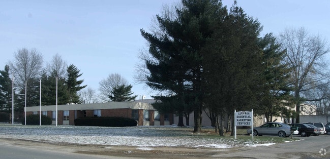
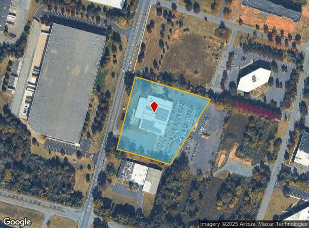
Property Record
1206 S River Rd, Cranbury, NJ 08512
NEARBY LISTINGS FOR SALE OR LEASE
Property Detail
1206 S River Rd
New York-Jersey City-White Plains, NY-NJ
Hanovia Indust Dev
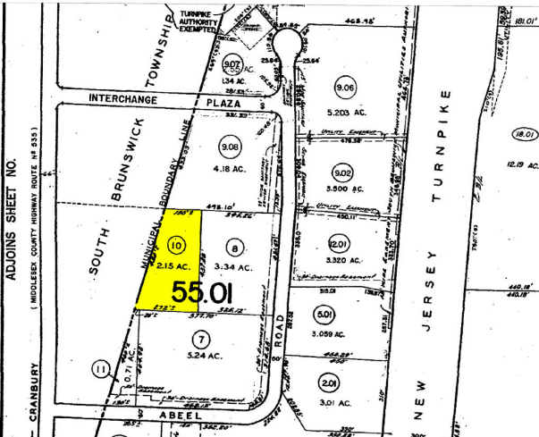
21-00008-0000-00003-02
3.839 AC SOLAR
Vacantlandnec
Middlesex
AE
New Jersey
34023C0253F
3.2
2024
3.84 AC
2025
Exit 8A
008700
Northern New Jersey
DEMOGRAPHICS near 1206 S River Rd
1 Mile
3 Mile
5 Mile
2024 Total Population
2,909
28,996
93,031
2029 Population
2,831
28,679
92,728
Pop Growth 2024-2029
(2.68%)
(1.09%)
(0.33%)
Average Age
61
53
44
2024 Total Households
1,673
13,085
36,359
HH Growth 2024-2029
(3.41%)
(1.74%)
(0.72%)
Median Household Inc
$55,760
$83,833
$112,221
Avg Household Size
1.70
2.20
2.50
2024 Avg HH Vehicles
1.00
2.00
2.00
Median Home Value
$148,262
$348,014
$440,584
Median Year Built
1977
1985
1987
Nearby Places
- Restaurants
- Banks
- Shops
- Fitness
- Groceries
PUBLIC TRANSPORTATION
COMMUTER RAIL
Princeton Junction (Northeast Corridor Line - NJ Transit Commuter Rail (NJ Transit), Princeton Branch - NJ Transit Commuter Rail (NJ Transit))
DRIVE
WALK
Distance
Princeton Junction (Northeast Corridor Line - NJ Transit Commuter Rail (NJ Transit), Princeton Branch - NJ Transit Commuter Rail (NJ Transit))
16 min
8.8 mi
AIRPORT
Newark Liberty International
DRIVE
WALK
Distance
Newark Liberty International
36 min
35.6 mi
Freight Ports
New York Container Terminal
DRIVE
WALK
Distance
New York Container Terminal
1 min
25.6 mi
Nearby Properties
Address
Land Use
TOTAL SIZE
Lot Size
Zoning
Address
Land Use
TOTAL SIZE
Lot Size
Zoning
161,447 SF
67.62 AC
R30
Address
Land Use
TOTAL SIZE
Lot Size
Zoning
212.16 AC
I-3
Address
Land Use
TOTAL SIZE
Lot Size
Zoning
42.10 AC
LI5
Address
Land Use
TOTAL SIZE
Lot Size
Zoning
1,154,372 SF
167.04 AC
LI
Address
Land Use
TOTAL SIZE
Lot Size
Zoning
1,145,608 SF
73.19 AC
LI
Address
Land Use
TOTAL SIZE
Lot Size
Zoning
80.34 AC
LI5
Address
Land Use
TOTAL SIZE
Lot Size
Zoning
983,940 SF
62.53 AC
LI
Address
Land Use
TOTAL SIZE
Lot Size
Zoning
63.54 AC
LI
Address
Land Use
TOTAL SIZE
Lot Size
Zoning
69.34 AC
LI
Address
Land Use
TOTAL SIZE
Lot Size
Zoning
47.51 AC
I/LI
Address
Land Use
TOTAL SIZE
Lot Size
Zoning
53.31 AC
LI
Address
Land Use
TOTAL SIZE
Lot Size
Zoning
58.21 AC
LI
Address
Land Use
TOTAL SIZE
Lot Size
Zoning
382,699 SF
29.60 AC
R30
Address
Land Use
TOTAL SIZE
Lot Size
Zoning
29,951 SF
55.65 AC
R20
Address
Land Use
TOTAL SIZE
Lot Size
Zoning
74.64 AC
LI
Address
Land Use
TOTAL SIZE
Lot Size
Zoning
83.35 AC
I/LA
Address
Land Use
TOTAL SIZE
Lot Size
Zoning
2,338 SF
58.26 AC
I/LI
Address
Land Use
TOTAL SIZE
Lot Size
Zoning
53.31 AC
LI
Address
Land Use
TOTAL SIZE
Lot Size
Zoning
51.28 AC
LI
Address
Land Use
TOTAL SIZE
Lot Size
Zoning
69.94 AC
ILIS
Address
Land Use
TOTAL SIZE
Lot Size
Zoning
528,314 SF
31.98 AC
LI
Address
Land Use
TOTAL SIZE
Lot Size
Zoning
207.40 AC
OR
Address
Land Use
TOTAL SIZE
Lot Size
Zoning
53.98 AC
LI
Address
Land Use
TOTAL SIZE
Lot Size
Zoning
28,155 SF
90.95 AC
I3R4
Address
Land Use
TOTAL SIZE
Lot Size
Zoning
46.04 AC
I/LI
Address
Land Use
TOTAL SIZE
Lot Size
Zoning
38.20 AC
LI
Address
Land Use
TOTAL SIZE
Lot Size
Zoning
29.74 AC
R30
Address
Land Use
TOTAL SIZE
Lot Size
Zoning
79.67 AC
I-3
Address
Land Use
TOTAL SIZE
Lot Size
Zoning
38.99 AC
LI
Address
Land Use
TOTAL SIZE
Lot Size
Zoning
50.73 AC
I-3
The World's #1 Commercial Real Estate Marketplace
Connect with us
© 2025 CoStar Group
The information above has been obtained from sources believed reliable. While we do not doubt its accuracy we have not verified it and make no guarantee, warranty or representation about it. It is your responsibility to independently confirm its accuracy and completeness. Any projections, opinions, assumptions, or estimates used are for example only and do not represent the current or future performance of the property. The value of this transaction to you depends on tax and other factors which should be evaluated by your tax, financial, and legal advisors. You and your advisors should conduct a careful, independent investigation of the property to determine to your satisfaction the suitability of the property for your needs.