Property Record
1206 National Hwy, Cumberland, MD 21502


NEARBY LISTINGS FOR SALE OR LEASE
-
-
View all Cumberland listings for sale on LoopNet.com
Property Detail
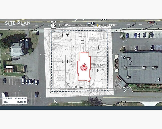
1206 National Hwy
Other Market Areas
View Add
Cumberland, MD-WV
32,902 SF 1206 NATL HWY LOTS 4-5 MT VIEW ADDN
29-007977
Allegany
Restaurantdrivein
Maryland
2025
4,5
2025
0.76 AC
001401
Maryland West/Hagerstown
3,295 SF
DEMOGRAPHICS near 1206 National Hwy
1 Mile
3 Mile
5 Mile
2024 Total Population
1,543
13,508
42,214
2029 Population
1,498
13,227
41,452
Pop Growth 2024-2029
(2.92%)
(2.08%)
(1.81%)
Average Age
45
44
43
2024 Total Households
655
4,496
17,130
HH Growth 2024-2029
(3.36%)
(2.65%)
(2.12%)
Median Household Inc
$73,345
$69,378
$50,062
Avg Household Size
2.30
2.30
2.20
2024 Avg HH Vehicles
2.00
2.00
2.00
Median Home Value
$161,590
$156,195
$138,887
Median Year Built
1960
1960
1955
Nearby Places
Map Layers
Map Styles
 Street
 Aerial
- Restaurants
- Banks
- Shops
- Fitness
- Groceries
PUBLIC TRANSPORTATION
COMMUTER RAIL
Cumberland Amtrak Station (Capitol Limited - Amtrak)
DRIVE
WALK
Distance
Cumberland Amtrak Station (Capitol Limited - Amtrak)
8 min
4.9 mi
Freight Ports
Port of Baltimore
DRIVE
WALK
Distance
Port of Baltimore
164 min
143.0 mi
SALE & LEASE HISTORY
LISTING DATE
SALE/LEASE

Nov 27, 2023
For Sale
Nearby Properties
Address
Land Use
TOTAL SIZE
Lot Size
Zoning
Address
Land Use
TOTAL SIZE
Lot Size
Zoning
230,816 SF
161.23 AC
I-B2
Address
Land Use
TOTAL SIZE
Lot Size
Zoning
40,845 SF
26.24 AC
R-O
Address
Land Use
TOTAL SIZE
Lot Size
Zoning
65,725 SF
13.33 AC
I
Address
Land Use
TOTAL SIZE
Lot Size
Zoning
58,327 SF
20.67 AC
B
Address
Land Use
TOTAL SIZE
Lot Size
Zoning
29,144 SF
20.75 AC
B
Address
Land Use
TOTAL SIZE
Lot Size
Zoning
151,773 SF
4.48 AC
Address
Land Use
TOTAL SIZE
Lot Size
Zoning
90,097 SF
35.50 AC
B
Address
Land Use
TOTAL SIZE
Lot Size
Zoning
18,138 SF
5.74 AC
B
Address
Land Use
TOTAL SIZE
Lot Size
Zoning
114,728 SF
16.34 AC
B
Address
Land Use
TOTAL SIZE
Lot Size
Zoning
4,972 SF
5.37 AC
B
Address
Land Use
TOTAL SIZE
Lot Size
Zoning
25,340 SF
14.90 AC
R
Address
Land Use
TOTAL SIZE
Lot Size
Zoning
61,486 SF
5.94 AC
Address
Land Use
TOTAL SIZE
Lot Size
Zoning
55,771 SF
2.42 AC
B
Address
Land Use
TOTAL SIZE
Lot Size
Zoning
46,845 SF
38.24 AC
R-R
Address
Land Use
TOTAL SIZE
Lot Size
Zoning
105,544 SF
17.09 AC
B
Address
Land Use
TOTAL SIZE
Lot Size
Zoning
29,236 SF
6.89 AC
Address
Land Use
TOTAL SIZE
Lot Size
Zoning
109,875 SF
39.52 AC
R-S
Address
Land Use
TOTAL SIZE
Lot Size
Zoning
52,402 SF
5.18 AC
Address
Land Use
TOTAL SIZE
Lot Size
Zoning
7,020 SF
1.88 AC
B
Address
Land Use
TOTAL SIZE
Lot Size
Zoning
26,142 SF
8.88 AC
B
Address
Land Use
TOTAL SIZE
Lot Size
Zoning
3,528 SF
1.60 AC
B
Address
Land Use
TOTAL SIZE
Lot Size
Zoning
43,214 SF
1.90 AC
B
Address
Land Use
TOTAL SIZE
Lot Size
Zoning
6,734 SF
2.19 AC
Address
Land Use
TOTAL SIZE
Lot Size
Zoning
39,234 SF
8.50 AC
B
Address
Land Use
TOTAL SIZE
Lot Size
Zoning
9,030 SF
2.90 AC
B
Address
Land Use
TOTAL SIZE
Lot Size
Zoning
17,618 SF
1.84 AC
A
Address
Land Use
TOTAL SIZE
Lot Size
Zoning
20,634 SF
8.06 AC
A
Address
Land Use
TOTAL SIZE
Lot Size
Zoning
12,890 SF
1.23 AC
B
Address
Land Use
TOTAL SIZE
Lot Size
Zoning
17,193 SF
1.73 AC
Address
Land Use
TOTAL SIZE
Lot Size
Zoning
2,296 SF
2.42 AC
B
The World's #1 Commercial Real Estate Marketplace
Connect with us
© 2026 CoStar Group
The information above has been obtained from sources believed reliable. While we do not doubt its accuracy we have not verified it and make no guarantee, warranty or representation about it. It is your responsibility to independently confirm its accuracy and completeness. Any projections, opinions, assumptions, or estimates used are for example only and do not represent the current or future performance of the property. The value of this transaction to you depends on tax and other factors which should be evaluated by your tax, financial, and legal advisors. You and your advisors should conduct a careful, independent investigation of the property to determine to your satisfaction the suitability of the property for your needs.