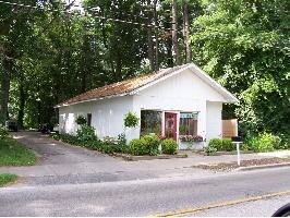
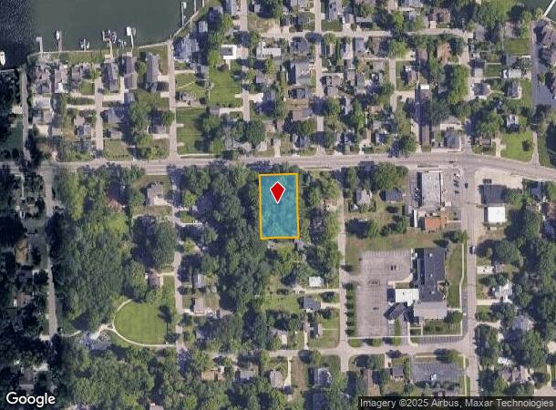
Property Record
1206 S Shore Dr, Holland, MI 49423
NEARBY LISTINGS FOR SALE OR LEASE
Property Detail
1206 S Shore Dr
Grand Rapids-Wyoming, MI
Rutgers Add
70-15-35-427-017
LOT 37 & PART OF LOT 38 COM 43 FT S OF NE COR SD LOT, TH W 11 FT, S 48 FT, E 1 FT TO E LI LOT 38, TH N TO BEG RUTGERS ADD TO
Storebuilding
Ottawa
X
Michigan
26005C0020G
37-38
2024
0.54 AC
2025
Holland West
022600
West Michigan
858 SF
DEMOGRAPHICS near 1206 S Shore Dr
1 Mile
3 Mile
5 Mile
2024 Total Population
4,835
42,588
76,462
2029 Population
5,088
44,447
79,811
Pop Growth 2024-2029
+ 5.23%
+ 4.37%
+ 4.38%
Average Age
44
41
40
2024 Total Households
2,008
16,020
28,816
HH Growth 2024-2029
+ 5.13%
+ 4.52%
+ 4.53%
Median Household Inc
$88,815
$83,589
$74,416
Avg Household Size
2.40
2.50
2.50
2024 Avg HH Vehicles
2.00
2.00
2.00
Median Home Value
$292,169
$271,391
$248,079
Median Year Built
1974
1972
1978
Nearby Places
Map Layers
Map Styles
 Street
 Aerial
- Restaurants
- Banks
- Shops
- Fitness
- Groceries
PUBLIC TRANSPORTATION
COMMUTER RAIL
Holland Amtrak Station (Pere Marquette - Amtrak)
DRIVE
WALK
Distance
Holland Amtrak Station (Pere Marquette - Amtrak)
10 min
4.0 mi
Freight Ports
Port Milwaukee
DRIVE
WALK
Distance
Port Milwaukee
279 min
236.3 mi
Nearby Properties
Address
Land Use
TOTAL SIZE
Lot Size
Zoning
Address
Land Use
TOTAL SIZE
Lot Size
Zoning
556,819 SF
85.45 AC
Address
Land Use
TOTAL SIZE
Lot Size
Zoning
329,784 SF
38.51 AC
I-2
Address
Land Use
TOTAL SIZE
Lot Size
Zoning
589,649 SF
92.65 AC
Address
Land Use
TOTAL SIZE
Lot Size
Zoning
137,732 SF
12.94 AC
C-2
Address
Land Use
TOTAL SIZE
Lot Size
Zoning
177,800 SF
12.34 AC
I-2
Address
Land Use
TOTAL SIZE
Lot Size
Zoning
114,088 SF
10.79 AC
PRD
Address
Land Use
TOTAL SIZE
Lot Size
Zoning
181,754 SF
13.44 AC
R3
Address
Land Use
TOTAL SIZE
Lot Size
Zoning
372,017 SF
17.60 AC
R-2
Address
Land Use
TOTAL SIZE
Lot Size
Zoning
122,026 SF
15.03 AC
R3
Address
Land Use
TOTAL SIZE
Lot Size
Zoning
146,357 SF
20.04 AC
Address
Land Use
TOTAL SIZE
Lot Size
Zoning
22,344 SF
8.16 AC
R-3
Address
Land Use
TOTAL SIZE
Lot Size
Zoning
386,644 SF
22.74 AC
I
Address
Land Use
TOTAL SIZE
Lot Size
Zoning
201,907 SF
15.96 AC
I-2
Address
Land Use
TOTAL SIZE
Lot Size
Zoning
133,887 SF
13.50 AC
NA
Address
Land Use
TOTAL SIZE
Lot Size
Zoning
33,605 SF
0.25 AC
C-3
Address
Land Use
TOTAL SIZE
Lot Size
Zoning
77,643 SF
3.79 AC
C-2
Address
Land Use
TOTAL SIZE
Lot Size
Zoning
238,987 SF
38.35 AC
NA
Address
Land Use
TOTAL SIZE
Lot Size
Zoning
42,831 SF
0.67 AC
C-3
Address
Land Use
TOTAL SIZE
Lot Size
Zoning
17,854 SF
3.94 AC
C-2
Address
Land Use
TOTAL SIZE
Lot Size
Zoning
59,836 SF
6.70 AC
NA
Address
Land Use
TOTAL SIZE
Lot Size
Zoning
99,082 SF
5.05 AC
I-2
Address
Land Use
TOTAL SIZE
Lot Size
Zoning
5.54 AC
Address
Land Use
TOTAL SIZE
Lot Size
Zoning
44,595 SF
0.44 AC
C-3
Address
Land Use
TOTAL SIZE
Lot Size
Zoning
41,872 SF
1.49 AC
I-1
Address
Land Use
TOTAL SIZE
Lot Size
Zoning
22,607 SF
0.30 AC
C-3
Address
Land Use
TOTAL SIZE
Lot Size
Zoning
134,166 SF
9.18 AC
NA
Address
Land Use
TOTAL SIZE
Lot Size
Zoning
82,800 SF
6.15 AC
R-5
Address
Land Use
TOTAL SIZE
Lot Size
Zoning
33,576 SF
23.60 AC
I-1
Address
Land Use
TOTAL SIZE
Lot Size
Zoning
55,581 SF
0.66 AC
C-2
Address
Land Use
TOTAL SIZE
Lot Size
Zoning
83.40 AC
OBOD
The World's #1 Commercial Real Estate Marketplace
Connect with us
© 2025 CoStar Group
The information above has been obtained from sources believed reliable. While we do not doubt its accuracy we have not verified it and make no guarantee, warranty or representation about it. It is your responsibility to independently confirm its accuracy and completeness. Any projections, opinions, assumptions, or estimates used are for example only and do not represent the current or future performance of the property. The value of this transaction to you depends on tax and other factors which should be evaluated by your tax, financial, and legal advisors. You and your advisors should conduct a careful, independent investigation of the property to determine to your satisfaction the suitability of the property for your needs.