Property Record
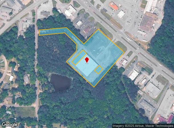
Highway 231, Ozark, AL 36360
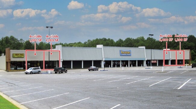
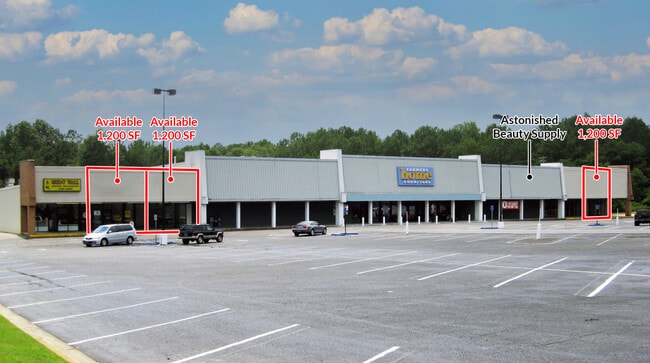
Current Lease Availabilities
NEARBY LISTINGS FOR SALE OR LEASE
Property Detail
Highway 231
06-09-32-4-000-001.0190
5.8 AC (C) PT. E2-SE4 BEG. 455'(S) NWLY OF INT. SW R/W OF HWY 231 & E LINE OF SEC.; SWLY 317.59'; NWLY 102.07'; SWLY 79.52'; SELY 59.88'; NELY 79.52'; SELY 42.17' SWLY 269.9'; NWLY 400'; NELY 75'(S); SELY 90'(S); NELY 189.96'; NWLY 60. 01'; SWLY 189.
Retailwithmorethanonenonretailuse
Dale
X
Alabama
01045C0135D
5.80 AC
2025
Dothan/Enterprise
2024
Other Market Areas
020700
Ozark, AL
36,040 SF
DEMOGRAPHICS near Highway 231
1 Mile
3 Mile
5 Mile
2024 Total Population
2,908
10,305
15,439
2029 Population
2,929
10,297
15,393
Pop Growth 2024-2029
+ 0.72%
(0.08%)
(0.30%)
Average Age
39
42
42
2024 Total Households
1,283
4,501
6,605
HH Growth 2024-2029
+ 0.86%
+ 0.07%
(0.17%)
Median Household Inc
$40,234
$40,054
$43,351
Avg Household Size
2.20
2.20
2.30
2024 Avg HH Vehicles
2.00
2.00
2.00
Median Home Value
$121,166
$138,859
$135,120
Median Year Built
1969
1971
1975
Nearby Places
- Restaurants
- Banks
- Shops
- Fitness
- Groceries
PUBLIC TRANSPORTATION
AIRPORT
Dothan Regional
DRIVE
WALK
Distance
Dothan Regional
26 min
17.5 mi
Freight Ports
Port of Panama City
DRIVE
WALK
Distance
Port of Panama City
140 min
107.3 mi
Nearby Properties
Address
Land Use
TOTAL SIZE
Lot Size
Zoning
Address
Land Use
TOTAL SIZE
Lot Size
Zoning
7.90 AC
Address
Land Use
TOTAL SIZE
Lot Size
Zoning
160,913 SF
24.70 AC
Address
Land Use
TOTAL SIZE
Lot Size
Zoning
220,000 SF
42.61 AC
Address
Land Use
TOTAL SIZE
Lot Size
Zoning
17,220 SF
0.50 AC
Address
Land Use
TOTAL SIZE
Lot Size
Zoning
10,552 SF
9.30 AC
Address
Land Use
TOTAL SIZE
Lot Size
Zoning
1,902 SF
10 AC
Address
Land Use
TOTAL SIZE
Lot Size
Zoning
12,464 SF
3 AC
O
Address
Land Use
TOTAL SIZE
Lot Size
Zoning
30 AC
Address
Land Use
TOTAL SIZE
Lot Size
Zoning
4.04 AC
Address
Land Use
TOTAL SIZE
Lot Size
Zoning
8,490 SF
1.96 AC
Address
Land Use
TOTAL SIZE
Lot Size
Zoning
1.80 AC
Address
Land Use
TOTAL SIZE
Lot Size
Zoning
0.96 AC
Address
Land Use
TOTAL SIZE
Lot Size
Zoning
12,800 SF
6.50 AC
Address
Land Use
TOTAL SIZE
Lot Size
Zoning
1,680 SF
2.65 AC
Address
Land Use
TOTAL SIZE
Lot Size
Zoning
16,224 SF
1.70 AC
Address
Land Use
TOTAL SIZE
Lot Size
Zoning
3,780 SF
2.50 AC
Address
Land Use
TOTAL SIZE
Lot Size
Zoning
25,828 SF
7.20 AC
Address
Land Use
TOTAL SIZE
Lot Size
Zoning
29,600 SF
8.20 AC
Address
Land Use
TOTAL SIZE
Lot Size
Zoning
14 AC
Address
Land Use
TOTAL SIZE
Lot Size
Zoning
860 SF
2.90 AC
Address
Land Use
TOTAL SIZE
Lot Size
Zoning
16 AC
Address
Land Use
TOTAL SIZE
Lot Size
Zoning
Address
Land Use
TOTAL SIZE
Lot Size
Zoning
7.50 AC
Address
Land Use
TOTAL SIZE
Lot Size
Zoning
5.89 AC
Address
Land Use
TOTAL SIZE
Lot Size
Zoning
12,000 SF
1.70 AC
Address
Land Use
TOTAL SIZE
Lot Size
Zoning
8,064 SF
11.70 AC
Address
Land Use
TOTAL SIZE
Lot Size
Zoning
567 AC
Address
Land Use
TOTAL SIZE
Lot Size
Zoning
Address
Land Use
TOTAL SIZE
Lot Size
Zoning
7.76 AC
The World's #1 Commercial Real Estate Marketplace
Connect with us
© 2025 CoStar Group
The information above has been obtained from sources believed reliable. While we do not doubt its accuracy we have not verified it and make no guarantee, warranty or representation about it. It is your responsibility to independently confirm its accuracy and completeness. Any projections, opinions, assumptions, or estimates used are for example only and do not represent the current or future performance of the property. The value of this transaction to you depends on tax and other factors which should be evaluated by your tax, financial, and legal advisors. You and your advisors should conduct a careful, independent investigation of the property to determine to your satisfaction the suitability of the property for your needs.