Property Record
12061 Katy Rd, Fort Worth, TX 76244
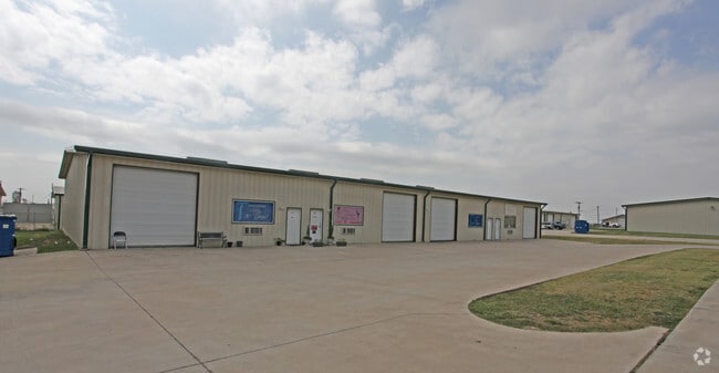

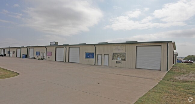
Property Detail
12061 Katy Rd
Dallas-Fort Worth-Arlington, TX
U-HOOK RANCH ADDITION LOT 4
41197283
Tarrant
Commercialnec
Texas
B and X Area of moderate flood hazard, usually the area between the limits of the 100-year and 500-year floods.
4
2025
4.84 AC
2025
NE Tarrant/Alliance
113945
Dallas/Ft Worth
50,640 SF
NEARBY LISTINGS FOR SALE OR LEASE
DEMOGRAPHICS near 12061 Katy Rd
1 mile
3 mile
5 mile
2025 Total Population
12,708
91,402
213,052
2030 Population
13,591
96,360
225,049
Pop Growth 2025-2030
+ 6.95%
+ 5.42%
+ 5.63%
Average Age
36
37
38
2025 Total Households
4,161
29,967
72,147
HH Growth 2025-2030
+ 7.09%
+ 5.61%
+ 5.93%
Median Household Inc
$104,488
$124,313
$125,961
Avg Household Size
3.00
3.00
2.90
2025 Avg HH Vehicles
2.00
2.00
2.00
Median Home Value
$428,978
$440,997
$437,302
Median Year Built
2006
2005
2003
Nearby Places
Map Layers
Map Styles
 Street
 Aerial
Layers
 Traffic
 Biking
Places
Listings with unknown addresses are not visible on the map
- Restaurants
- Banks
- Shops
- Fitness
- Groceries
PUBLIC TRANSPORTATION
AIRPORT
Dallas-Fort Worth International
Drive
Walk
Distance
Dallas-Fort Worth International
26 min
19.8 mi
Dallas Love Field
Drive
Walk
Distance
Dallas Love Field
45 min
33.5 mi
Freight Ports
Port of Shreveport
Drive
Walk
Distance
Port of Shreveport
254 min
233.3 mi
Nearby Properties
Address
Land Use
TOTAL SIZE
Lot Size
Zoning
Address
Land Use
TOTAL SIZE
Lot Size
Zoning
1,542,470 SF
147.33 AC
Address
Land Use
TOTAL SIZE
Lot Size
Zoning
562,929 SF
15.89 AC
Address
Land Use
TOTAL SIZE
Lot Size
Zoning
300,000 SF
12.03 AC
Address
Land Use
TOTAL SIZE
Lot Size
Zoning
311,224 SF
8.22 AC
Address
Land Use
TOTAL SIZE
Lot Size
Zoning
471,408 SF
17.56 AC
Address
Land Use
TOTAL SIZE
Lot Size
Zoning
261,836 SF
33.32 AC
Address
Land Use
TOTAL SIZE
Lot Size
Zoning
261,836 SF
51.66 AC
Address
Land Use
TOTAL SIZE
Lot Size
Zoning
340,366 SF
53 AC
Address
Land Use
TOTAL SIZE
Lot Size
Zoning
259,825 SF
14.95 AC
Address
Land Use
TOTAL SIZE
Lot Size
Zoning
298,773 SF
17.40 AC
Address
Land Use
TOTAL SIZE
Lot Size
Zoning
314,241 SF
13.98 AC
Address
Land Use
TOTAL SIZE
Lot Size
Zoning
270,044 SF
30.51 AC
Address
Land Use
TOTAL SIZE
Lot Size
Zoning
308,713 SF
17.58 AC
Address
Land Use
TOTAL SIZE
Lot Size
Zoning
293,939 SF
16.63 AC
Address
Land Use
TOTAL SIZE
Lot Size
Zoning
756,351 SF
33 AC
Address
Land Use
TOTAL SIZE
Lot Size
Zoning
279,612 SF
18.46 AC
Address
Land Use
TOTAL SIZE
Lot Size
Zoning
756,351 SF
33 AC
Address
Land Use
TOTAL SIZE
Lot Size
Zoning
367,008 SF
29.55 AC
Address
Land Use
TOTAL SIZE
Lot Size
Zoning
191,905 SF
13.09 AC
Address
Land Use
TOTAL SIZE
Lot Size
Zoning
258,155 SF
5.55 AC
Address
Land Use
TOTAL SIZE
Lot Size
Zoning
210,408 SF
14.56 AC
Address
Land Use
TOTAL SIZE
Lot Size
Zoning
930,000 SF
99.51 AC
Address
Land Use
TOTAL SIZE
Lot Size
Zoning
557,161 SF
29.73 AC
Address
Land Use
TOTAL SIZE
Lot Size
Zoning
174,438 SF
12.38 AC
Address
Land Use
TOTAL SIZE
Lot Size
Zoning
220,000 SF
57.83 AC
Address
Land Use
TOTAL SIZE
Lot Size
Zoning
219,469 SF
13.52 AC
Address
Land Use
TOTAL SIZE
Lot Size
Zoning
176,055 SF
42.12 AC
Address
Land Use
TOTAL SIZE
Lot Size
Zoning
540,040 SF
26.62 AC
Address
Land Use
TOTAL SIZE
Lot Size
Zoning
516,941 SF
29.74 AC
Address
Land Use
TOTAL SIZE
Lot Size
Zoning
214,425 SF
6.24 AC
The World's #1 Commercial Real Estate Marketplace
Connect with us
© 2026 CoStar Group
The information above has been obtained from sources believed reliable. While we do not doubt its accuracy we have not verified it and make no guarantee, warranty or representation about it. It is your responsibility to independently confirm its accuracy and completeness. Any projections, opinions, assumptions, or estimates used are for example only and do not represent the current or future performance of the property. The value of this transaction to you depends on tax and other factors which should be evaluated by your tax, financial, and legal advisors. You and your advisors should conduct a careful, independent investigation of the property to determine to your satisfaction the suitability of the property for your needs.