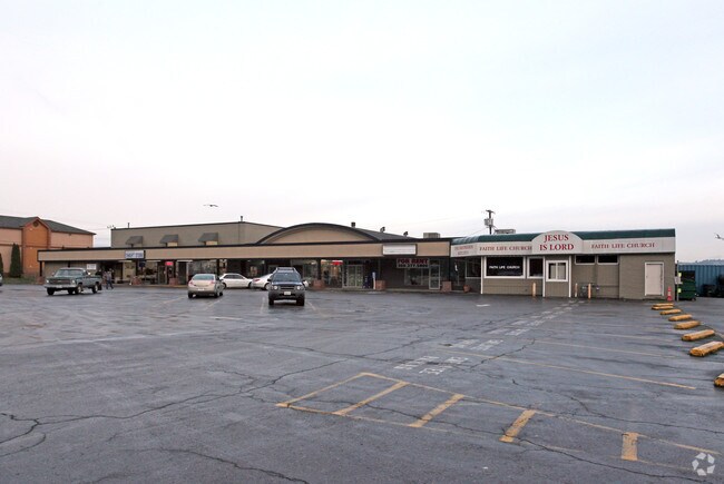
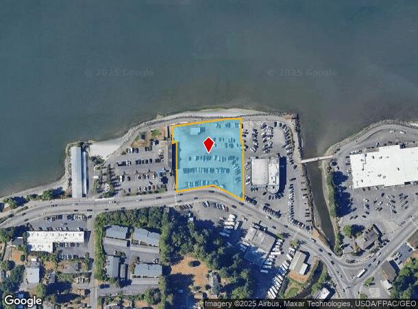
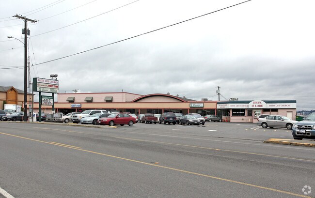
Property Record
1207 Bay St, Port Orchard, WA 98366
NEARBY LISTINGS FOR SALE OR LEASE
Property Detail
1207 Bay St
Bremerton-Silverdale, WA
Port Orchard
252401-2-018-2004
A PORTION OF GOVERNMENT LOT 1, SECTION 25, TOWNSHIP 24 NORTH, RANGE 1 EAST, W.M.; BEING THAT PORTION OF SAID GOVERNMENT LOT 1, LYING BETWEEN THE NORTH BOUNDARY OF BAY STREET, TOWN OF PORT ORCHARD, AND THE MEANDER LINE, AND BOUNDED ON THE EAST BY WEST
Servicestation
Kitsap
AE
Washington
53035C0367F
1
2025
1.57 AC
2026
Port Orchard
092400
Bremerton/Silverdale
25,962 SF
DEMOGRAPHICS near 1207 Bay St
1 Mile
3 Mile
5 Mile
2024 Total Population
4,421
63,594
114,749
2029 Population
4,474
64,553
116,278
Pop Growth 2024-2029
+ 1.20%
+ 1.51%
+ 1.33%
Average Age
42
38
40
2024 Total Households
1,544
24,168
43,957
HH Growth 2024-2029
+ 0.78%
+ 1.70%
+ 1.46%
Median Household Inc
$76,591
$63,189
$71,041
Avg Household Size
2.40
2.30
2.40
2024 Avg HH Vehicles
2.00
2.00
2.00
Median Home Value
$337,430
$367,147
$411,780
Median Year Built
1964
1974
1979
Nearby Places
Map Layers
Map Styles
 Street
 Aerial
- Restaurants
- Banks
- Shops
- Fitness
- Groceries
PUBLIC TRANSPORTATION
AIRPORT
Seattle Paine Field International
DRIVE
WALK
Distance
Seattle Paine Field International
99 min
49.2 mi
Seattle-Tacoma International
DRIVE
WALK
Distance
Seattle-Tacoma International
71 min
49.6 mi
Freight Ports
Port of Seattle
DRIVE
WALK
Distance
Port of Seattle
81 min
59.9 mi
Nearby Properties
Address
Land Use
TOTAL SIZE
Lot Size
Zoning
Address
Land Use
TOTAL SIZE
Lot Size
Zoning
552 SF
17.39 AC
CITY
Address
Land Use
TOTAL SIZE
Lot Size
Zoning
21,408 SF
8.26 AC
BVSAP
Address
Land Use
TOTAL SIZE
Lot Size
Zoning
143,022 SF
11.24 AC
R4
Address
Land Use
TOTAL SIZE
Lot Size
Zoning
127,853 SF
7.41 AC
R4
Address
Land Use
TOTAL SIZE
Lot Size
Zoning
135,371 SF
6.04 AC
R4
Address
Land Use
TOTAL SIZE
Lot Size
Zoning
112,847 SF
6.80 AC
UM
Address
Land Use
TOTAL SIZE
Lot Size
Zoning
17,592 SF
11.61 AC
UM
Address
Land Use
TOTAL SIZE
Lot Size
Zoning
25,973 SF
8.20 AC
CC
Address
Land Use
TOTAL SIZE
Lot Size
Zoning
110,994 SF
5.35 AC
R4
Address
Land Use
TOTAL SIZE
Lot Size
Zoning
1,092 SF
5.70 AC
CC
Address
Land Use
TOTAL SIZE
Lot Size
Zoning
125,582 SF
4.02 AC
NC
Address
Land Use
TOTAL SIZE
Lot Size
Zoning
0.54 AC
CITY
Address
Land Use
TOTAL SIZE
Lot Size
Zoning
110,778 SF
9.24 AC
CC
Address
Land Use
TOTAL SIZE
Lot Size
Zoning
Address
Land Use
TOTAL SIZE
Lot Size
Zoning
1,344 SF
5.47 AC
R-40
Address
Land Use
TOTAL SIZE
Lot Size
Zoning
79,615 SF
1.25 AC
DSAP
Address
Land Use
TOTAL SIZE
Lot Size
Zoning
158,870 SF
14.62 AC
CC
Address
Land Use
TOTAL SIZE
Lot Size
Zoning
185,893 SF
17.89 AC
CC
Address
Land Use
TOTAL SIZE
Lot Size
Zoning
77,580 SF
8.62 AC
UM
Address
Land Use
TOTAL SIZE
Lot Size
Zoning
63,213 SF
4.15 AC
R-10
Address
Land Use
TOTAL SIZE
Lot Size
Zoning
14,660 SF
6.14 AC
UM
Address
Land Use
TOTAL SIZE
Lot Size
Zoning
14,660 SF
6.07 AC
UM
Address
Land Use
TOTAL SIZE
Lot Size
Zoning
58,376 SF
6.68 AC
R-18
Address
Land Use
TOTAL SIZE
Lot Size
Zoning
64,584 SF
4.92 AC
R-40
Address
Land Use
TOTAL SIZE
Lot Size
Zoning
49,604 SF
5.49 AC
UM
Address
Land Use
TOTAL SIZE
Lot Size
Zoning
68,079 SF
2.16 AC
BVSAP
Address
Land Use
TOTAL SIZE
Lot Size
Zoning
62,642 SF
4.91 AC
UM
Address
Land Use
TOTAL SIZE
Lot Size
Zoning
60,518 SF
2.62 AC
R-18
Address
Land Use
TOTAL SIZE
Lot Size
Zoning
56,006 SF
4.72 AC
UM
Address
Land Use
TOTAL SIZE
Lot Size
Zoning
55,412 SF
1.74 AC
R-18
The World's #1 Commercial Real Estate Marketplace
Connect with us
© 2025 CoStar Group
The information above has been obtained from sources believed reliable. While we do not doubt its accuracy we have not verified it and make no guarantee, warranty or representation about it. It is your responsibility to independently confirm its accuracy and completeness. Any projections, opinions, assumptions, or estimates used are for example only and do not represent the current or future performance of the property. The value of this transaction to you depends on tax and other factors which should be evaluated by your tax, financial, and legal advisors. You and your advisors should conduct a careful, independent investigation of the property to determine to your satisfaction the suitability of the property for your needs.