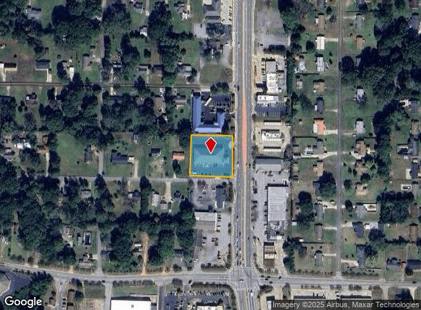
Property Record
1207 N Highway 19 Hwy N, Thomaston, GA 30286

NEARBY LISTINGS FOR SALE OR LEASE
-
-
View all Thomaston listings for sale on LoopNet.com
Property Detail
1207 N Highway 19 Hwy N
Thomaston, GA
North Thomaston Commercial
043B-113 01
LOTS 1 & 2 BLOCK C PB 12/163
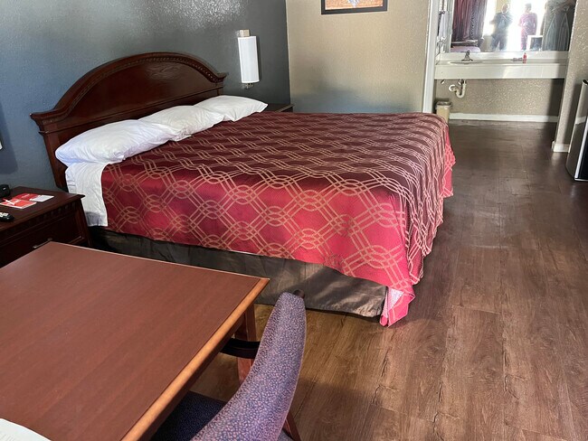
Motel
Upson
X
Georgia
13171C0150C
1,2
2024
0.82 AC
2025
Georgia South Area
010201
Other Market Areas
14,732 SF
DEMOGRAPHICS near 1207 N Highway 19 Hwy N
1 Mile
3 Mile
5 Mile
2024 Total Population
2,217
12,489
21,133
2029 Population
2,250
12,873
21,835
Pop Growth 2024-2029
+ 1.49%
+ 3.07%
+ 3.32%
Average Age
40
41
41
2024 Total Households
891
5,115
8,569
HH Growth 2024-2029
+ 1.35%
+ 2.93%
+ 3.17%
Median Household Inc
$46,250
$42,621
$42,566
Avg Household Size
2.40
2.40
2.40
2024 Avg HH Vehicles
2.00
2.00
2.00
Median Home Value
$116,029
$107,491
$131,721
Median Year Built
1971
1970
1970
Nearby Places
Map Layers
Map Styles
 Street
 Aerial
- Restaurants
- Banks
- Shops
- Fitness
- Groceries
SALE & LEASE HISTORY
LISTING DATE
SALE/LEASE

Jan 10, 2023
For Sale
Nearby Properties
Address
Land Use
TOTAL SIZE
Lot Size
Zoning
Address
Land Use
TOTAL SIZE
Lot Size
Zoning
1,850 SF
94.56 AC
M2
Address
Land Use
TOTAL SIZE
Lot Size
Zoning
61,594 SF
31.44 AC
M1
Address
Land Use
TOTAL SIZE
Lot Size
Zoning
58,908 SF
104.55 AC
M1
Address
Land Use
TOTAL SIZE
Lot Size
Zoning
9,588 SF
12.17 AC
PI
Address
Land Use
TOTAL SIZE
Lot Size
Zoning
174,343 SF
18.48 AC
C2
Address
Land Use
TOTAL SIZE
Lot Size
Zoning
103,020 SF
11.06 AC
C2
Address
Land Use
TOTAL SIZE
Lot Size
Zoning
48,476 SF
17.80 AC
ES2
Address
Land Use
TOTAL SIZE
Lot Size
Zoning
140,288 SF
31.67 AC
M2
Address
Land Use
TOTAL SIZE
Lot Size
Zoning
322,698 SF
72.25 AC
M2
Address
Land Use
TOTAL SIZE
Lot Size
Zoning
31,412 SF
3.69 AC
DT
Address
Land Use
TOTAL SIZE
Lot Size
Zoning
125,647 SF
15.67 AC
C2
Address
Land Use
TOTAL SIZE
Lot Size
Zoning
34,537 SF
6.65 AC
C2
Address
Land Use
TOTAL SIZE
Lot Size
Zoning
24,662 SF
1.09 AC
DT
Address
Land Use
TOTAL SIZE
Lot Size
Zoning
28,266 SF
2.44 AC
PD
Address
Land Use
TOTAL SIZE
Lot Size
Zoning
488 SF
11.97 AC
MR
Address
Land Use
TOTAL SIZE
Lot Size
Zoning
13,765 SF
7.92 AC
PD
Address
Land Use
TOTAL SIZE
Lot Size
Zoning
4,472 SF
11.57 AC
MR
Address
Land Use
TOTAL SIZE
Lot Size
Zoning
61,916 SF
8.93 AC
C2
Address
Land Use
TOTAL SIZE
Lot Size
Zoning
247,227 SF
18.54 AC
M2
Address
Land Use
TOTAL SIZE
Lot Size
Zoning
4,704 SF
172.30 AC
M2
Address
Land Use
TOTAL SIZE
Lot Size
Zoning
44,356 SF
5.75 AC
AR
Address
Land Use
TOTAL SIZE
Lot Size
Zoning
21,373 SF
2.77 AC
C2
Address
Land Use
TOTAL SIZE
Lot Size
Zoning
5,640 SF
5 AC
MR
Address
Land Use
TOTAL SIZE
Lot Size
Zoning
19,660 SF
1.26 AC
DT
Address
Land Use
TOTAL SIZE
Lot Size
Zoning
7,444 SF
5.44 AC
MR
Address
Land Use
TOTAL SIZE
Lot Size
Zoning
12,810 SF
1.73 AC
R1
Address
Land Use
TOTAL SIZE
Lot Size
Zoning
19,520 SF
4.03 AC
C2
Address
Land Use
TOTAL SIZE
Lot Size
Zoning
107,468 SF
7.21 AC
M2
Address
Land Use
TOTAL SIZE
Lot Size
Zoning
600 SF
6 AC
MR
Address
Land Use
TOTAL SIZE
Lot Size
Zoning
30,052 SF
35.54 AC
C2
The World's #1 Commercial Real Estate Marketplace
Connect with us
© 2025 CoStar Group
The information above has been obtained from sources believed reliable. While we do not doubt its accuracy we have not verified it and make no guarantee, warranty or representation about it. It is your responsibility to independently confirm its accuracy and completeness. Any projections, opinions, assumptions, or estimates used are for example only and do not represent the current or future performance of the property. The value of this transaction to you depends on tax and other factors which should be evaluated by your tax, financial, and legal advisors. You and your advisors should conduct a careful, independent investigation of the property to determine to your satisfaction the suitability of the property for your needs.