Property Record
1207 Highway 45 N, Columbus, MS 39705
NEARBY LISTINGS FOR SALE OR LEASE
Property Detail
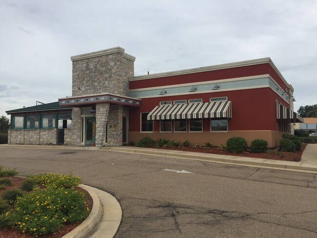
1207 Highway 45 N
Restaurantbuilding
PT SE4 SE4 1207 HWY 45 N CHILES RESTURANT
X
Lowndes
28087C0170K
Mississippi
2025
1 AC
2025
Other Market Areas
000901
Columbus, MS
4,308 SF
57W20-01-04001
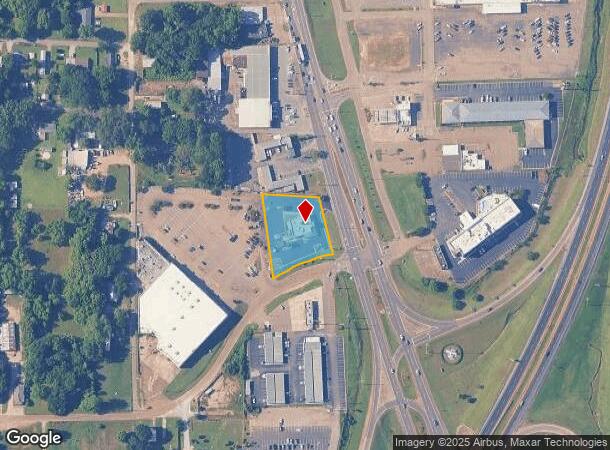
DEMOGRAPHICS near 1207 Highway 45 N
1 Mile
3 Mile
5 Mile
2024 Total Population
3,416
18,029
30,126
2029 Population
3,417
17,804
29,418
Pop Growth 2024-2029
+ 0.03%
(1.25%)
(2.35%)
Average Age
41
40
40
2024 Total Households
1,526
7,621
12,438
HH Growth 2024-2029
0.00%
(1.22%)
(2.31%)
Median Household Inc
$46,860
$39,145
$40,099
Avg Household Size
2.10
2.20
2.20
2024 Avg HH Vehicles
2.00
2.00
2.00
Median Home Value
$137,240
$144,264
$145,358
Median Year Built
1968
1973
1976
Nearby Places
Map Layers
Map Styles
 Street
 Aerial
- Restaurants
- Banks
- Shops
- Fitness
- Groceries
PUBLIC TRANSPORTATION
AIRPORT
Golden Triangle Regional
DRIVE
WALK
Distance
Golden Triangle Regional
21 min
12.8 mi
Freight Ports
Port of Mobile
DRIVE
WALK
Distance
Port of Mobile
259 min
222.3 mi
SALE & LEASE HISTORY
LISTING DATE
SALE/LEASE

Sep 24, 2016
For Sale
Nearby Properties
Address
Land Use
TOTAL SIZE
Lot Size
Zoning
Address
Land Use
TOTAL SIZE
Lot Size
Zoning
13,500 SF
12.20 AC
Address
Land Use
TOTAL SIZE
Lot Size
Zoning
210,798 SF
12.88 AC
Address
Land Use
TOTAL SIZE
Lot Size
Zoning
76,286 SF
0.02 AC
Address
Land Use
TOTAL SIZE
Lot Size
Zoning
304,375 SF
30.80 AC
Address
Land Use
TOTAL SIZE
Lot Size
Zoning
38,000 SF
1.80 AC
Address
Land Use
TOTAL SIZE
Lot Size
Zoning
11,402 SF
30.30 AC
Address
Land Use
TOTAL SIZE
Lot Size
Zoning
4,000 SF
11.40 AC
Address
Land Use
TOTAL SIZE
Lot Size
Zoning
16,589 SF
47.50 AC
Address
Land Use
TOTAL SIZE
Lot Size
Zoning
59,891 SF
9.30 AC
Address
Land Use
TOTAL SIZE
Lot Size
Zoning
134,799 SF
15.29 AC
Address
Land Use
TOTAL SIZE
Lot Size
Zoning
3,063 SF
10.19 AC
Address
Land Use
TOTAL SIZE
Lot Size
Zoning
60,623 SF
3.33 AC
Address
Land Use
TOTAL SIZE
Lot Size
Zoning
10,512 SF
1.31 AC
Address
Land Use
TOTAL SIZE
Lot Size
Zoning
5,400 SF
0.36 AC
Address
Land Use
TOTAL SIZE
Lot Size
Zoning
45,903 SF
2 AC
Address
Land Use
TOTAL SIZE
Lot Size
Zoning
47,304 SF
4.60 AC
Address
Land Use
TOTAL SIZE
Lot Size
Zoning
57,175 SF
3.03 AC
Address
Land Use
TOTAL SIZE
Lot Size
Zoning
40,929 SF
2.65 AC
Address
Land Use
TOTAL SIZE
Lot Size
Zoning
35,057 SF
1.83 AC
Address
Land Use
TOTAL SIZE
Lot Size
Zoning
2,703 SF
3 AC
Address
Land Use
TOTAL SIZE
Lot Size
Zoning
48,539 SF
0.02 AC
Address
Land Use
TOTAL SIZE
Lot Size
Zoning
4,000 SF
Address
Land Use
TOTAL SIZE
Lot Size
Zoning
1,795 SF
8.60 AC
Address
Land Use
TOTAL SIZE
Lot Size
Zoning
68,428 SF
8.70 AC
Address
Land Use
TOTAL SIZE
Lot Size
Zoning
6,290 SF
1 AC
Address
Land Use
TOTAL SIZE
Lot Size
Zoning
8,412 SF
7.10 AC
Address
Land Use
TOTAL SIZE
Lot Size
Zoning
103,842 SF
0.02 AC
Address
Land Use
TOTAL SIZE
Lot Size
Zoning
50,570 SF
2.50 AC
Address
Land Use
TOTAL SIZE
Lot Size
Zoning
12.20 AC
Address
Land Use
TOTAL SIZE
Lot Size
Zoning
86,498 SF
8.46 AC
The World's #1 Commercial Real Estate Marketplace
Connect with us
© 2025 CoStar Group
The information above has been obtained from sources believed reliable. While we do not doubt its accuracy we have not verified it and make no guarantee, warranty or representation about it. It is your responsibility to independently confirm its accuracy and completeness. Any projections, opinions, assumptions, or estimates used are for example only and do not represent the current or future performance of the property. The value of this transaction to you depends on tax and other factors which should be evaluated by your tax, financial, and legal advisors. You and your advisors should conduct a careful, independent investigation of the property to determine to your satisfaction the suitability of the property for your needs.