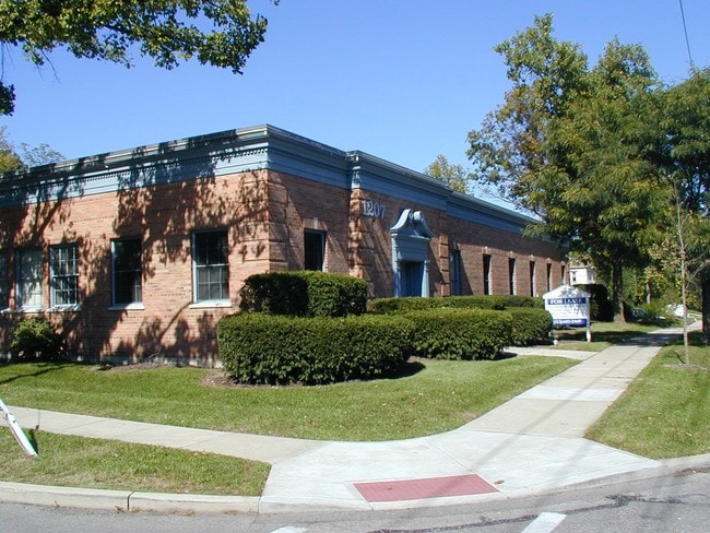
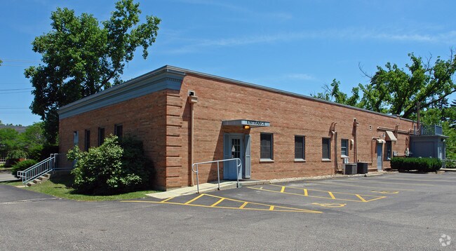
Property Record
1207 Springfield Pike, Cincinnati, OH 45215

Property Detail
1207 Springfield Pike
Cincinnati, OH-KY-IN
SPRINGFIELD PK 151.13 X 175 IR PT LOT 5 A PENDERYS SUB
592-0004-0183
Hamilton
Medicalbuilding
Ohio
B and X Area of moderate flood hazard, usually the area between the limits of the 100-year and 500-year floods.
5
2025
0.52 AC
2025
Forest Park/West
022601
Cincinnati/Dayton
5,340 SF
NEARBY LISTINGS FOR SALE OR LEASE
DEMOGRAPHICS near 1207 Springfield Pike
1 mile
3 mile
5 mile
2025 Total Population
9,679
63,822
207,280
2030 Population
9,814
64,354
208,749
Pop Growth 2025-2030
+ 1.39%
+ 0.83%
+ 0.71%
Average Age
40
41
41
2025 Total Households
3,698
26,651
87,731
HH Growth 2025-2030
+ 1.51%
+ 0.91%
+ 0.73%
Median Household Inc
$79,923
$70,632
$65,545
Avg Household Size
2.60
2.30
2.30
2025 Avg HH Vehicles
2.00
2.00
2.00
Median Home Value
$319,565
$219,640
$213,403
Median Year Built
1953
1957
1958
Nearby Places
Map Layers
Map Styles
 Street
 Aerial
Layers
 Traffic
 Biking
Places
Listings with unknown addresses are not visible on the map
- Restaurants
- Banks
- Shops
- Fitness
- Groceries
PUBLIC TRANSPORTATION
AIRPORT
Cincinnati/Northern Kentucky International
Drive
Walk
Distance
Cincinnati/Northern Kentucky International
40 min
23.4 mi
Nearby Properties
Address
Land Use
TOTAL SIZE
Lot Size
Zoning
Address
Land Use
TOTAL SIZE
Lot Size
Zoning
47.52 AC
Address
Land Use
TOTAL SIZE
Lot Size
Zoning
1,238 SF
14.03 AC
Address
Land Use
TOTAL SIZE
Lot Size
Zoning
Address
Land Use
TOTAL SIZE
Lot Size
Zoning
11,639 SF
7.87 AC
R2
Address
Land Use
TOTAL SIZE
Lot Size
Zoning
23.45 AC
Address
Land Use
TOTAL SIZE
Lot Size
Zoning
15.61 AC
Address
Land Use
TOTAL SIZE
Lot Size
Zoning
8,964 SF
11.61 AC
Address
Land Use
TOTAL SIZE
Lot Size
Zoning
25,098 SF
21.31 AC
Address
Land Use
TOTAL SIZE
Lot Size
Zoning
330,335 SF
0.80 AC
R3
Address
Land Use
TOTAL SIZE
Lot Size
Zoning
42.41 AC
Address
Land Use
TOTAL SIZE
Lot Size
Zoning
344,923 SF
18.47 AC
RM20
Address
Land Use
TOTAL SIZE
Lot Size
Zoning
13.08 AC
Address
Land Use
TOTAL SIZE
Lot Size
Zoning
5,085 SF
15.17 AC
Address
Land Use
TOTAL SIZE
Lot Size
Zoning
Address
Land Use
TOTAL SIZE
Lot Size
Zoning
Address
Land Use
TOTAL SIZE
Lot Size
Zoning
20.07 AC
B2
Address
Land Use
TOTAL SIZE
Lot Size
Zoning
2.22 AC
Address
Land Use
TOTAL SIZE
Lot Size
Zoning
6,652 SF
15.45 AC
R1
Address
Land Use
TOTAL SIZE
Lot Size
Zoning
Address
Land Use
TOTAL SIZE
Lot Size
Zoning
95,700 SF
18.40 AC
Address
Land Use
TOTAL SIZE
Lot Size
Zoning
Address
Land Use
TOTAL SIZE
Lot Size
Zoning
14.35 AC
Address
Land Use
TOTAL SIZE
Lot Size
Zoning
8,720 SF
33.28 AC
R3
Address
Land Use
TOTAL SIZE
Lot Size
Zoning
Address
Land Use
TOTAL SIZE
Lot Size
Zoning
2,400 SF
0.35 AC
R1
Address
Land Use
TOTAL SIZE
Lot Size
Zoning
121,747 SF
23.05 AC
R3
Address
Land Use
TOTAL SIZE
Lot Size
Zoning
23.41 AC
Address
Land Use
TOTAL SIZE
Lot Size
Zoning
31.98 AC
Address
Land Use
TOTAL SIZE
Lot Size
Zoning
6,346 SF
4.64 AC
Address
Land Use
TOTAL SIZE
Lot Size
Zoning
13.43 AC
The World's #1 Commercial Real Estate Marketplace
Connect with us
© 2026 CoStar Group
The information above has been obtained from sources believed reliable. While we do not doubt its accuracy we have not verified it and make no guarantee, warranty or representation about it. It is your responsibility to independently confirm its accuracy and completeness. Any projections, opinions, assumptions, or estimates used are for example only and do not represent the current or future performance of the property. The value of this transaction to you depends on tax and other factors which should be evaluated by your tax, financial, and legal advisors. You and your advisors should conduct a careful, independent investigation of the property to determine to your satisfaction the suitability of the property for your needs.