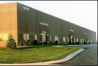
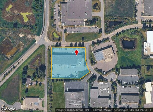
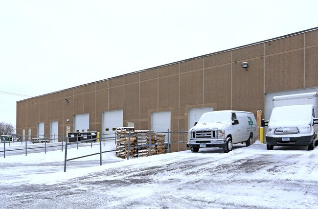
Property Record
12075 43Rd St Ne, Saint Michael, MN 55376
NEARBY LISTINGS FOR SALE OR LEASE
-
-
View all Saint Michael listings for sale on LoopNet.com
Property Detail
12075 43Rd St Ne
Minneapolis/St Paul
St Michael Industrial Park
Minneapolis-St. Paul-Bloomington, MN-WI
SECT-07 TWP-120 RANGE-023 ST MICHAEL INDUSTRIAL PARK LOT-001 BLOCK-001 BLOCK-001
114-274-001010
Wright
Lightindustrial
Minnesota
2025
1
2025
3.07 AC
100807
Wright County
4,920 SF
DEMOGRAPHICS near 12075 43Rd St Ne
1 Mile
3 Mile
5 Mile
2024 Total Population
5,289
30,631
55,156
2029 Population
5,911
34,078
60,504
Pop Growth 2024-2029
+ 11.76%
+ 11.25%
+ 9.70%
Average Age
37
35
36
2024 Total Households
1,861
10,050
18,241
HH Growth 2024-2029
+ 11.98%
+ 11.36%
+ 9.72%
Median Household Inc
$116,656
$121,599
$120,213
Avg Household Size
2.80
3.00
3.00
2024 Avg HH Vehicles
2.00
2.00
2.00
Median Home Value
$355,555
$324,532
$340,107
Median Year Built
1999
2001
2002
Nearby Places
Map Layers
Map Styles
 Street
 Aerial
- Restaurants
- Banks
- Shops
- Fitness
- Groceries
Nearby Properties
Address
Land Use
TOTAL SIZE
Lot Size
Zoning
Address
Land Use
TOTAL SIZE
Lot Size
Zoning
25,380 SF
130.75 AC
Address
Land Use
TOTAL SIZE
Lot Size
Zoning
44.82 AC
Address
Land Use
TOTAL SIZE
Lot Size
Zoning
40,984 SF
19.16 AC
Address
Land Use
TOTAL SIZE
Lot Size
Zoning
40,984 SF
34.62 AC
Address
Land Use
TOTAL SIZE
Lot Size
Zoning
4,240 SF
2.45 AC
Address
Land Use
TOTAL SIZE
Lot Size
Zoning
58.85 AC
Address
Land Use
TOTAL SIZE
Lot Size
Zoning
Address
Land Use
TOTAL SIZE
Lot Size
Zoning
Address
Land Use
TOTAL SIZE
Lot Size
Zoning
Address
Land Use
TOTAL SIZE
Lot Size
Zoning
31,553 SF
41.63 AC
Address
Land Use
TOTAL SIZE
Lot Size
Zoning
Address
Land Use
TOTAL SIZE
Lot Size
Zoning
Address
Land Use
TOTAL SIZE
Lot Size
Zoning
7,932 SF
13.29 AC
Address
Land Use
TOTAL SIZE
Lot Size
Zoning
21,935 SF
4.15 AC
Address
Land Use
TOTAL SIZE
Lot Size
Zoning
Address
Land Use
TOTAL SIZE
Lot Size
Zoning
Address
Land Use
TOTAL SIZE
Lot Size
Zoning
26,187 SF
2.05 AC
Address
Land Use
TOTAL SIZE
Lot Size
Zoning
78,300 SF
3.81 AC
Address
Land Use
TOTAL SIZE
Lot Size
Zoning
22,258 SF
2.35 AC
Address
Land Use
TOTAL SIZE
Lot Size
Zoning
16.21 AC
Address
Land Use
TOTAL SIZE
Lot Size
Zoning
Address
Land Use
TOTAL SIZE
Lot Size
Zoning
15,560 SF
59.44 AC
Address
Land Use
TOTAL SIZE
Lot Size
Zoning
105,140 SF
12.88 AC
Address
Land Use
TOTAL SIZE
Lot Size
Zoning
12,250 SF
20.65 AC
Address
Land Use
TOTAL SIZE
Lot Size
Zoning
78,708 SF
7.71 AC
Address
Land Use
TOTAL SIZE
Lot Size
Zoning
80,321 SF
17.88 AC
Address
Land Use
TOTAL SIZE
Lot Size
Zoning
28,764 SF
4.10 AC
Address
Land Use
TOTAL SIZE
Lot Size
Zoning
Address
Land Use
TOTAL SIZE
Lot Size
Zoning
98,262 SF
10.38 AC
The World's #1 Commercial Real Estate Marketplace
Connect with us
© 2025 CoStar Group
The information above has been obtained from sources believed reliable. While we do not doubt its accuracy we have not verified it and make no guarantee, warranty or representation about it. It is your responsibility to independently confirm its accuracy and completeness. Any projections, opinions, assumptions, or estimates used are for example only and do not represent the current or future performance of the property. The value of this transaction to you depends on tax and other factors which should be evaluated by your tax, financial, and legal advisors. You and your advisors should conduct a careful, independent investigation of the property to determine to your satisfaction the suitability of the property for your needs.