Property Record
1208 Idaho St, Lewiston, ID 83501
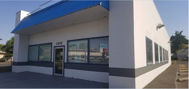
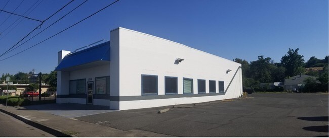
Property Detail
1208 Idaho St
Lewiston, ID-WA
Nez Perce
RPL1550000002A
Idaho
Taxexempt
0.34 AC
C4
Nez Perce
3,440 SF
Coeur D'Alene
NEARBY LISTINGS FOR SALE OR LEASE
DEMOGRAPHICS near 1208 Idaho St
1 mile
3 mile
5 mile
2024 Total Population
8,300
36,948
55,857
2029 Population
8,757
38,686
58,517
Pop Growth 2024-2029
+ 5.51%
+ 4.70%
+ 4.76%
Average Age
37
41
42
2024 Total Households
3,400
15,518
23,311
HH Growth 2024-2029
+ 5.50%
+ 4.73%
+ 4.76%
Median Household Inc
$55,450
$54,209
$64,473
Avg Household Size
2.30
2.30
2.30
2024 Avg HH Vehicles
2.00
2.00
2.00
Median Home Value
$250,449
$254,236
$271,095
Median Year Built
1948
1966
1972
Nearby Places
Map Layers
Map Styles
 Street
 Aerial
Transit
 Traffic
 Biking
Places
Listings with unknown addresses are not visible on the map
- Restaurants
- Banks
- Shops
- Fitness
- Groceries
PUBLIC TRANSPORTATION
AIRPORT
Lewiston/Nez Perce County
Drive
Walk
Distance
Lewiston/Nez Perce County
15 min
6.2 mi
Pullman/Moscow Regional
Drive
Walk
Distance
Pullman/Moscow Regional
55 min
38.5 mi
SALE & LEASE HISTORY
LISTING DATE
SALE/LEASE

Sep 24, 2016
For Sale
Oct 31, 2017
For Lease
May 30, 2018
For Sale
Apr 15, 2019
For Lease
Nearby Properties
Address
Land Use
TOTAL SIZE
Lot Size
Zoning
Address
Land Use
TOTAL SIZE
Lot Size
Zoning
135.38 AC
M2
Address
Land Use
TOTAL SIZE
Lot Size
Zoning
296,259 SF
2.47 AC
NHMU
Address
Land Use
TOTAL SIZE
Lot Size
Zoning
139,285 SF
23.97 AC
PD
Address
Land Use
TOTAL SIZE
Lot Size
Zoning
0.48 AC
Address
Land Use
TOTAL SIZE
Lot Size
Zoning
25,950 SF
4.48 AC
R2
Address
Land Use
TOTAL SIZE
Lot Size
Zoning
22.44 AC
1
Address
Land Use
TOTAL SIZE
Lot Size
Zoning
156,391 SF
7.14 AC
C6
Address
Land Use
TOTAL SIZE
Lot Size
Zoning
113,162 SF
4.42 AC
PD
Address
Land Use
TOTAL SIZE
Lot Size
Zoning
44,800 SF
5 AC
P
Address
Land Use
TOTAL SIZE
Lot Size
Zoning
160,676 SF
8.24 AC
1
Address
Land Use
TOTAL SIZE
Lot Size
Zoning
25,810 SF
2.21 AC
Address
Land Use
TOTAL SIZE
Lot Size
Zoning
51,272 SF
7.02 AC
P
Address
Land Use
TOTAL SIZE
Lot Size
Zoning
2.24 AC
Address
Land Use
TOTAL SIZE
Lot Size
Zoning
50,594 SF
3.52 AC
PD
Address
Land Use
TOTAL SIZE
Lot Size
Zoning
35,000 SF
5.81 AC
P
Address
Land Use
TOTAL SIZE
Lot Size
Zoning
97,896 SF
4.88 AC
C6
Address
Land Use
TOTAL SIZE
Lot Size
Zoning
52,828 SF
2.54 AC
C6
Address
Land Use
TOTAL SIZE
Lot Size
Zoning
54,459 SF
4.06 AC
R3
Address
Land Use
TOTAL SIZE
Lot Size
Zoning
47,750 SF
8.37 AC
C4
Address
Land Use
TOTAL SIZE
Lot Size
Zoning
116,698 SF
10.49 AC
PD
Address
Land Use
TOTAL SIZE
Lot Size
Zoning
75,600 SF
2.96 AC
R4
Address
Land Use
TOTAL SIZE
Lot Size
Zoning
26,879 SF
0.32 AC
PD
Address
Land Use
TOTAL SIZE
Lot Size
Zoning
57,000 SF
4.36 AC
R2A
Address
Land Use
TOTAL SIZE
Lot Size
Zoning
27,404 SF
2.90 AC
PD
Address
Land Use
TOTAL SIZE
Lot Size
Zoning
59,238 SF
12.31 AC
PD
Address
Land Use
TOTAL SIZE
Lot Size
Zoning
59,704 SF
6.20 AC
C6
Address
Land Use
TOTAL SIZE
Lot Size
Zoning
76,747 SF
7.40 AC
PD
Address
Land Use
TOTAL SIZE
Lot Size
Zoning
10,375 SF
2.80 AC
R3
Address
Land Use
TOTAL SIZE
Lot Size
Zoning
36,455 SF
1.11 AC
C3
Address
Land Use
TOTAL SIZE
Lot Size
Zoning
58,901 SF
4.72 AC
R3
The World's #1 Commercial Real Estate Marketplace
Connect with us
© 2026 CoStar Group
The information above has been obtained from sources believed reliable. While we do not doubt its accuracy we have not verified it and make no guarantee, warranty or representation about it. It is your responsibility to independently confirm its accuracy and completeness. Any projections, opinions, assumptions, or estimates used are for example only and do not represent the current or future performance of the property. The value of this transaction to you depends on tax and other factors which should be evaluated by your tax, financial, and legal advisors. You and your advisors should conduct a careful, independent investigation of the property to determine to your satisfaction the suitability of the property for your needs.