Property Record
12080 S 36Th West Ave, Sapulpa, OK 74066

NEARBY LISTINGS FOR SALE OR LEASE
-
-
View all Sapulpa listings for sale on LoopNet.com
Property Detail
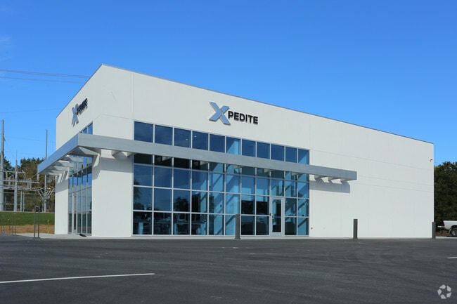
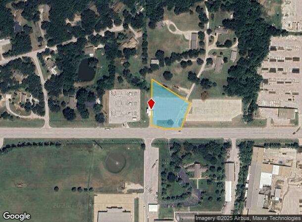
12080 S 36Th West Ave
0000-33-018-012-0-004-00
T18n-R12e
Officebuilding
33-18-12 TR IN SE SE BEG SW COR TH N00'08 00 E60 TO TRUE POB TH N00'08 00 E275 S58'28 08 E275.9 7 S26'08 00 W145 S89'50 00 W1
X
Creek
40037C0310D
Oklahoma
2024
1.23 AC
2025
Creek County
021401
Tulsa
560 SF
Tulsa, OK
DEMOGRAPHICS near 12080 S 36Th West Ave
1 Mile
3 Mile
5 Mile
2024 Total Population
1,832
21,282
69,246
2029 Population
1,906
21,996
71,859
Pop Growth 2024-2029
+ 4.04%
+ 3.35%
+ 3.77%
Average Age
40
36
38
2024 Total Households
717
7,289
25,617
HH Growth 2024-2029
+ 4.04%
+ 3.40%
+ 3.80%
Median Household Inc
$72,430
$85,635
$69,993
Avg Household Size
2.50
2.90
2.70
2024 Avg HH Vehicles
2.00
2.00
2.00
Median Home Value
$262,121
$239,927
$211,426
Median Year Built
2008
2000
1994
Nearby Places
Map Layers
Map Styles
 Street
 Aerial
- Restaurants
- Banks
- Shops
- Fitness
- Groceries
PUBLIC TRANSPORTATION
AIRPORT
Tulsa International
DRIVE
WALK
Distance
Tulsa International
31 min
22.4 mi
Freight Ports
Tulsa Port Of Catoosa
DRIVE
WALK
Distance
Tulsa Port Of Catoosa
39 min
31.1 mi
Nearby Properties
Address
Land Use
TOTAL SIZE
Lot Size
Zoning
Address
Land Use
TOTAL SIZE
Lot Size
Zoning
49,344 SF
5.34 AC
CG
Address
Land Use
TOTAL SIZE
Lot Size
Zoning
52,441 SF
12.79 AC
CS
Address
Land Use
TOTAL SIZE
Lot Size
Zoning
58,907 SF
5 AC
CG
Address
Land Use
TOTAL SIZE
Lot Size
Zoning
358,394 SF
38.86 AC
Address
Land Use
TOTAL SIZE
Lot Size
Zoning
31,313 SF
17.95 AC
IL
Address
Land Use
TOTAL SIZE
Lot Size
Zoning
49,025 SF
10.75 AC
AG
Address
Land Use
TOTAL SIZE
Lot Size
Zoning
87,304 SF
3.29 AC
CN
Address
Land Use
TOTAL SIZE
Lot Size
Zoning
137,364 SF
14.65 AC
RS3
Address
Land Use
TOTAL SIZE
Lot Size
Zoning
186,012 SF
9.31 AC
RS3
Address
Land Use
TOTAL SIZE
Lot Size
Zoning
331,125 SF
17.64 AC
CG
Address
Land Use
TOTAL SIZE
Lot Size
Zoning
25,555 SF
17.31 AC
CN
Address
Land Use
TOTAL SIZE
Lot Size
Zoning
15,636 SF
4.91 AC
AG
Address
Land Use
TOTAL SIZE
Lot Size
Zoning
11,436 SF
1.38 AC
CG
Address
Land Use
TOTAL SIZE
Lot Size
Zoning
216,308 SF
23.91 AC
CG
Address
Land Use
TOTAL SIZE
Lot Size
Zoning
23,600 SF
15.69 AC
Address
Land Use
TOTAL SIZE
Lot Size
Zoning
3,660 SF
10 AC
CG
Address
Land Use
TOTAL SIZE
Lot Size
Zoning
19,857 SF
3.44 AC
AG
Address
Land Use
TOTAL SIZE
Lot Size
Zoning
27.87 AC
IM
Address
Land Use
TOTAL SIZE
Lot Size
Zoning
16,068 SF
0.80 AC
CG
Address
Land Use
TOTAL SIZE
Lot Size
Zoning
32,408 SF
6.25 AC
AG
Address
Land Use
TOTAL SIZE
Lot Size
Zoning
11,745 SF
1.88 AC
AG
Address
Land Use
TOTAL SIZE
Lot Size
Zoning
78,660 SF
2 AC
CN
Address
Land Use
TOTAL SIZE
Lot Size
Zoning
55,225 SF
60.46 AC
Address
Land Use
TOTAL SIZE
Lot Size
Zoning
5,920 SF
7.67 AC
AG
Address
Land Use
TOTAL SIZE
Lot Size
Zoning
27,910 SF
2.54 AC
CG
Address
Land Use
TOTAL SIZE
Lot Size
Zoning
36.56 AC
AG
Address
Land Use
TOTAL SIZE
Lot Size
Zoning
5,971 SF
2.67 AC
AG
Address
Land Use
TOTAL SIZE
Lot Size
Zoning
33,128 SF
1.83 AC
RM2
Address
Land Use
TOTAL SIZE
Lot Size
Zoning
57,534 SF
1.73 AC
CG
Address
Land Use
TOTAL SIZE
Lot Size
Zoning
154,435 SF
7.68 AC
AG
The World's #1 Commercial Real Estate Marketplace
Connect with us
© 2025 CoStar Group
The information above has been obtained from sources believed reliable. While we do not doubt its accuracy we have not verified it and make no guarantee, warranty or representation about it. It is your responsibility to independently confirm its accuracy and completeness. Any projections, opinions, assumptions, or estimates used are for example only and do not represent the current or future performance of the property. The value of this transaction to you depends on tax and other factors which should be evaluated by your tax, financial, and legal advisors. You and your advisors should conduct a careful, independent investigation of the property to determine to your satisfaction the suitability of the property for your needs.