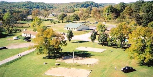
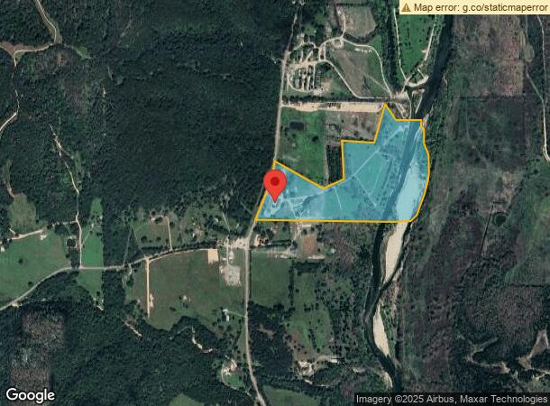
Property Record
12081 N Highway 10, Tahlequah, OK 74464

NEARBY LISTINGS FOR SALE OR LEASE
-
-
View all Tahlequah listings for sale on LoopNet.com
Property Detail
12081 N Highway 10
0000-01-17N-22E-0-011-00
T17N R22E S01 BEG NW/C SEC S00*36'00" W33' S88*38'00" E1310.79' FOR POB S12*06'14" W542.6 8' N86*26'21" W459.16' S03*17'12" E
Conveniencestore
Cherokee
A
Oklahoma
40021C0275D
43.26 AC
2024
Oklahoma East Area
2025
Other Market Areas
977600
Tahlequah, OK
3,456 SF
DEMOGRAPHICS near 12081 N Highway 10
1 Mile
3 Mile
5 Mile
2024 Total Population
59
1,531
11,491
2029 Population
63
1,662
12,111
Pop Growth 2024-2029
+ 6.78%
+ 8.56%
+ 5.40%
Average Age
39
40
37
2024 Total Households
22
575
4,431
HH Growth 2024-2029
+ 4.55%
+ 8.52%
+ 5.60%
Median Household Inc
$39,999
$56,451
$40,464
Avg Household Size
2.40
2.60
2.30
2024 Avg HH Vehicles
2.00
2.00
2.00
Median Home Value
$199,999
$186,585
$156,113
Median Year Built
1987
1992
1988
Nearby Places
- Restaurants
- Banks
- Shops
- Fitness
- Groceries
SALE & LEASE HISTORY
LISTING DATE
SALE/LEASE

Sep 07, 2021
For Sale
Nearby Properties
Address
Land Use
TOTAL SIZE
Lot Size
Zoning
Address
Land Use
TOTAL SIZE
Lot Size
Zoning
1,270 SF
1.64 AC
Address
Land Use
TOTAL SIZE
Lot Size
Zoning
2,772 SF
14.93 AC
Address
Land Use
TOTAL SIZE
Lot Size
Zoning
3,764 SF
61.50 AC
Address
Land Use
TOTAL SIZE
Lot Size
Zoning
1,024 SF
1.15 AC
Address
Land Use
TOTAL SIZE
Lot Size
Zoning
3,900 SF
2 AC
Address
Land Use
TOTAL SIZE
Lot Size
Zoning
2,800 SF
0.74 AC
Address
Land Use
TOTAL SIZE
Lot Size
Zoning
1,695 SF
0.98 AC
Address
Land Use
TOTAL SIZE
Lot Size
Zoning
2,740 SF
2 AC
Address
Land Use
TOTAL SIZE
Lot Size
Zoning
2,976 SF
6.13 AC
Address
Land Use
TOTAL SIZE
Lot Size
Zoning
1,530 SF
9.21 AC
Address
Land Use
TOTAL SIZE
Lot Size
Zoning
Address
Land Use
TOTAL SIZE
Lot Size
Zoning
1,440 SF
1.95 AC
Address
Land Use
TOTAL SIZE
Lot Size
Zoning
1,680 SF
0.99 AC
Address
Land Use
TOTAL SIZE
Lot Size
Zoning
4,800 SF
15.27 AC
Address
Land Use
TOTAL SIZE
Lot Size
Zoning
Address
Land Use
TOTAL SIZE
Lot Size
Zoning
1,216 SF
1.37 AC
Address
Land Use
TOTAL SIZE
Lot Size
Zoning
11.71 AC
Address
Land Use
TOTAL SIZE
Lot Size
Zoning
1,716 SF
Address
Land Use
TOTAL SIZE
Lot Size
Zoning
Address
Land Use
TOTAL SIZE
Lot Size
Zoning
784 SF
9.42 AC
Address
Land Use
TOTAL SIZE
Lot Size
Zoning
1,568 SF
7.40 AC
Address
Land Use
TOTAL SIZE
Lot Size
Zoning
3,200 SF
0.50 AC
Address
Land Use
TOTAL SIZE
Lot Size
Zoning
1.46 AC
Address
Land Use
TOTAL SIZE
Lot Size
Zoning
Address
Land Use
TOTAL SIZE
Lot Size
Zoning
3.09 AC
Address
Land Use
TOTAL SIZE
Lot Size
Zoning
1,890 SF
1.03 AC
Address
Land Use
TOTAL SIZE
Lot Size
Zoning
900 SF
0.40 AC
Address
Land Use
TOTAL SIZE
Lot Size
Zoning
Address
Land Use
TOTAL SIZE
Lot Size
Zoning
1,775 SF
The World's #1 Commercial Real Estate Marketplace
Connect with us
© 2025 CoStar Group
The information above has been obtained from sources believed reliable. While we do not doubt its accuracy we have not verified it and make no guarantee, warranty or representation about it. It is your responsibility to independently confirm its accuracy and completeness. Any projections, opinions, assumptions, or estimates used are for example only and do not represent the current or future performance of the property. The value of this transaction to you depends on tax and other factors which should be evaluated by your tax, financial, and legal advisors. You and your advisors should conduct a careful, independent investigation of the property to determine to your satisfaction the suitability of the property for your needs.