Property Record
1209 Cantrell Sansom Rd, Blue Mound, TX 76131


Save to a Folder
{{folder.Name}}
{{folder.ListingIds.length}} Properties
{{folder.ListingIds.length}} Property
Create a New Folder
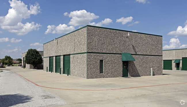
Property Detail
1209 Cantrell Sansom Rd
Dallas-Fort Worth-Arlington, TX
PRECISION WAY BLOCK 1 LOT 1
41036840
Tarrant
Commercialnec
Texas
AE The base floodplain where base flood elevations are provided. AE Zones are now used on new format FIRMs instead of A1-A30 Zones.
1
2025
6.42 AC
2025
Meacham Fld/Fossil Cr
114003
Dallas/Ft Worth
31,078 SF
NEARBY LISTINGS FOR SALE OR LEASE
DEMOGRAPHICS near 1209 Cantrell Sansom Rd
1 mile
3 mile
5 mile
2025 Total Population
10,259
87,353
294,230
2030 Population
10,740
91,879
310,435
Pop Growth 2025-2030
+ 4.69%
+ 5.18%
+ 5.51%
Average Age
35
36
35
2025 Total Households
3,493
30,329
97,158
HH Growth 2025-2030
+ 5.01%
+ 5.35%
+ 5.66%
Median Household Inc
$77,258
$83,972
$83,925
Avg Household Size
2.90
2.80
3.00
2025 Avg HH Vehicles
2.00
2.00
2.00
Median Home Value
$275,034
$305,201
$303,238
Median Year Built
2001
2001
1998
Nearby Places
Map Layers
Map Styles
 Street
 Aerial
Layers
 Traffic
 Biking
Places
Listings with unknown addresses are not visible on the map
- Restaurants
- Banks
- Shops
- Fitness
- Groceries
PUBLIC TRANSPORTATION
COMMUTER RAIL
Fort Worth (Heartland Flyer - Amtrak, Texas Eagle - Amtrak)
Drive
Walk
Distance
Fort Worth (Heartland Flyer - Amtrak, Texas Eagle - Amtrak)
15 min
9.5 mi
Fort Worth Intermodal Transit Center (TRINITY RAILWAY - Dallas Area Rapid Transit (DART))
Drive
Walk
Distance
Fort Worth Intermodal Transit Center (TRINITY RAILWAY - Dallas Area Rapid Transit (DART))
15 min
9.5 mi
AIRPORT
Dallas-Fort Worth International
Drive
Walk
Distance
Dallas-Fort Worth International
32 min
23.2 mi
Dallas Love Field
Drive
Walk
Distance
Dallas Love Field
43 min
31.9 mi
Freight Ports
Port of Shreveport
Drive
Walk
Distance
Port of Shreveport
253 min
231.1 mi
SALE & LEASE HISTORY
LISTING DATE
SALE/LEASE

Jun 15, 2022
For Sale
Nearby Properties
Address
Land Use
TOTAL SIZE
Lot Size
Zoning
Address
Land Use
TOTAL SIZE
Lot Size
Zoning
1,291,500 SF
61.22 AC
Address
Land Use
TOTAL SIZE
Lot Size
Zoning
586,500 SF
159.54 AC
Address
Land Use
TOTAL SIZE
Lot Size
Zoning
1,440,000 SF
73.42 AC
Address
Land Use
TOTAL SIZE
Lot Size
Zoning
332,094 SF
19.33 AC
Address
Land Use
TOTAL SIZE
Lot Size
Zoning
473,562 SF
24.63 AC
Address
Land Use
TOTAL SIZE
Lot Size
Zoning
1,020,300 SF
64.61 AC
Address
Land Use
TOTAL SIZE
Lot Size
Zoning
352,354 SF
17.02 AC
Address
Land Use
TOTAL SIZE
Lot Size
Zoning
1,009,800 SF
49.98 AC
Address
Land Use
TOTAL SIZE
Lot Size
Zoning
433,894 SF
18.99 AC
Address
Land Use
TOTAL SIZE
Lot Size
Zoning
935,532 SF
Address
Land Use
TOTAL SIZE
Lot Size
Zoning
385,697 SF
15.94 AC
Address
Land Use
TOTAL SIZE
Lot Size
Zoning
810,978 SF
45.84 AC
Address
Land Use
TOTAL SIZE
Lot Size
Zoning
715,000 SF
47.87 AC
Address
Land Use
TOTAL SIZE
Lot Size
Zoning
278,292 SF
16.35 AC
Address
Land Use
TOTAL SIZE
Lot Size
Zoning
344,992 SF
17.49 AC
Address
Land Use
TOTAL SIZE
Lot Size
Zoning
225,743 SF
19.54 AC
Address
Land Use
TOTAL SIZE
Lot Size
Zoning
312,219 SF
17.82 AC
Address
Land Use
TOTAL SIZE
Lot Size
Zoning
248,993 SF
15.40 AC
Address
Land Use
TOTAL SIZE
Lot Size
Zoning
263,411 SF
7.32 AC
Address
Land Use
TOTAL SIZE
Lot Size
Zoning
656,390 SF
33.33 AC
Address
Land Use
TOTAL SIZE
Lot Size
Zoning
269,995 SF
14.72 AC
Address
Land Use
TOTAL SIZE
Lot Size
Zoning
329,091 SF
21.73 AC
Address
Land Use
TOTAL SIZE
Lot Size
Zoning
290,034 SF
11.04 AC
Address
Land Use
TOTAL SIZE
Lot Size
Zoning
251,933 SF
86.07 AC
Address
Land Use
TOTAL SIZE
Lot Size
Zoning
266,403 SF
16.67 AC
Address
Land Use
TOTAL SIZE
Lot Size
Zoning
270,394 SF
16.43 AC
Address
Land Use
TOTAL SIZE
Lot Size
Zoning
566,816 SF
32.79 AC
Address
Land Use
TOTAL SIZE
Lot Size
Zoning
359,411 SF
17.77 AC
Address
Land Use
TOTAL SIZE
Lot Size
Zoning
689,600 SF
47.04 AC
Address
Land Use
TOTAL SIZE
Lot Size
Zoning
586,242 SF
59.44 AC
The World's #1 Commercial Real Estate Marketplace
Connect with us
© 2026 CoStar Group
The information above has been obtained from sources believed reliable. While we do not doubt its accuracy we have not verified it and make no guarantee, warranty or representation about it. It is your responsibility to independently confirm its accuracy and completeness. Any projections, opinions, assumptions, or estimates used are for example only and do not represent the current or future performance of the property. The value of this transaction to you depends on tax and other factors which should be evaluated by your tax, financial, and legal advisors. You and your advisors should conduct a careful, independent investigation of the property to determine to your satisfaction the suitability of the property for your needs.