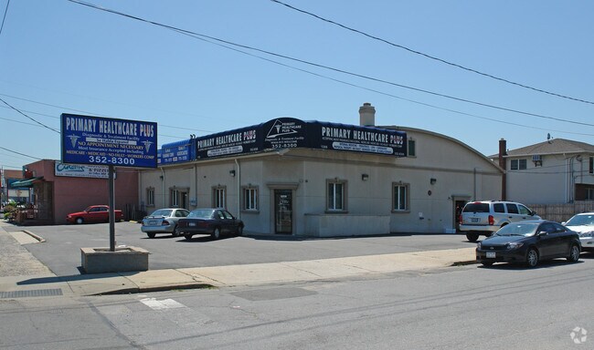
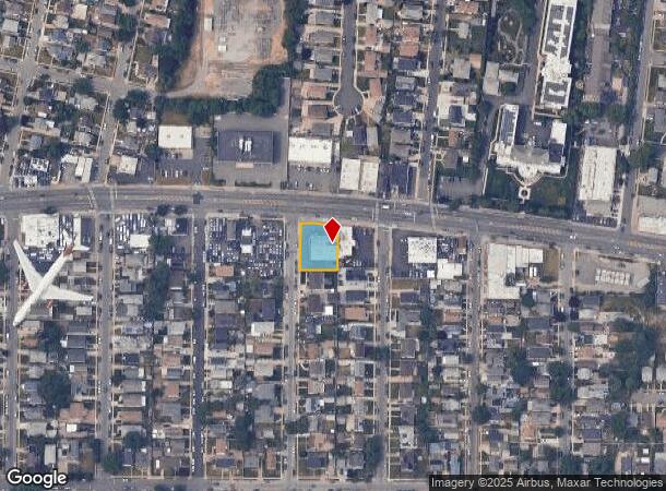
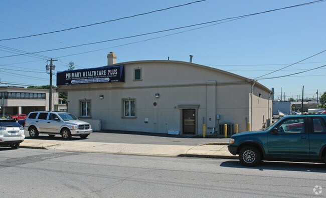
Property Record
1209 Hempstead Tpke, Franklin Square, NY 11010
NEARBY LISTINGS FOR SALE OR LEASE
Property Detail
1209 Hempstead Tpke
2089-35-037-00-0001-0
1-5
Officebuilding
Nassau
X
New York
36059C0210G
1
2025
0.29 AC
2025
Central Nassau
405400
Long Island (New York)
4,844 SF
Nassau County-Suffolk County, NY
DEMOGRAPHICS near 1209 Hempstead Tpke
1 Mile
3 Mile
5 Mile
2024 Total Population
34,369
263,794
764,620
2029 Population
32,958
254,132
731,625
Pop Growth 2024-2029
(4.11%)
(3.66%)
(4.32%)
Average Age
41
42
42
2024 Total Households
10,574
82,164
244,433
HH Growth 2024-2029
(4.18%)
(3.80%)
(4.55%)
Median Household Inc
$114,992
$120,954
$108,610
Avg Household Size
3.20
3.10
3.00
2024 Avg HH Vehicles
2.00
2.00
2.00
Median Home Value
$657,477
$675,100
$658,945
Median Year Built
1951
1950
1951
Nearby Places
- Restaurants
- Banks
- Shops
- Fitness
- Groceries
PUBLIC TRANSPORTATION
COMMUTER RAIL
Stewart Manor Station (Hempstead Branch - Long Island Rail Road)
DRIVE
WALK
Distance
Stewart Manor Station (Hempstead Branch - Long Island Rail Road)
3 min
1.7 mi
Nassau Boulevard Station (Hempstead Branch - Long Island Rail Road)
DRIVE
WALK
Distance
Nassau Boulevard Station (Hempstead Branch - Long Island Rail Road)
5 min
2.7 mi
AIRPORT
John F Kennedy International
DRIVE
WALK
Distance
John F Kennedy International
18 min
9.9 mi
LaGuardia
DRIVE
WALK
Distance
LaGuardia
24 min
14.0 mi
Westchester County
DRIVE
WALK
Distance
Westchester County
53 min
35.4 mi
Freight Ports
NY - Red Hook Container Terminal
DRIVE
WALK
Distance
NY - Red Hook Container Terminal
35 min
22.1 mi
Nearby Properties
Address
Land Use
TOTAL SIZE
Lot Size
Zoning
Address
Land Use
TOTAL SIZE
Lot Size
Zoning
129,378 SF
4.86 AC
R2A
Address
Land Use
TOTAL SIZE
Lot Size
Zoning
171,000 SF
2.76 AC
R2A
Address
Land Use
TOTAL SIZE
Lot Size
Zoning
99,814 SF
1.31 AC
R3-2
Address
Land Use
TOTAL SIZE
Lot Size
Zoning
170,000 SF
4.02 AC
R3-2
Address
Land Use
TOTAL SIZE
Lot Size
Zoning
155,000 SF
2.09 AC
R3A
Address
Land Use
TOTAL SIZE
Lot Size
Zoning
1,020 SF
12.33 AC
R3-2
Address
Land Use
TOTAL SIZE
Lot Size
Zoning
70,734 SF
2.94 AC
R2A
Address
Land Use
TOTAL SIZE
Lot Size
Zoning
32,000 SF
8.70 AC
M1-1
Address
Land Use
TOTAL SIZE
Lot Size
Zoning
90,974 SF
1.73 AC
R2A
Address
Land Use
TOTAL SIZE
Lot Size
Zoning
108,051 SF
0.96 AC
C8-1
Address
Land Use
TOTAL SIZE
Lot Size
Zoning
53,700 SF
2.92 AC
R4-1
Address
Land Use
TOTAL SIZE
Lot Size
Zoning
59,426 SF
0.65 AC
C8-1
Address
Land Use
TOTAL SIZE
Lot Size
Zoning
35,000 SF
2.16 AC
R3-2
Address
Land Use
TOTAL SIZE
Lot Size
Zoning
63,976 SF
11.35 AC
R3-2
Address
Land Use
TOTAL SIZE
Lot Size
Zoning
105,036 SF
0.66 AC
M1-2
Address
Land Use
TOTAL SIZE
Lot Size
Zoning
52,000 SF
1.34 AC
R3-2
Address
Land Use
TOTAL SIZE
Lot Size
Zoning
57,000 SF
2.16 AC
R2A
Address
Land Use
TOTAL SIZE
Lot Size
Zoning
29,346 SF
4.32 AC
R3-2
Address
Land Use
TOTAL SIZE
Lot Size
Zoning
36,500 SF
2 AC
R2A
Address
Land Use
TOTAL SIZE
Lot Size
Zoning
5,322,666 SF
86.10 AC
Address
Land Use
TOTAL SIZE
Lot Size
Zoning
32,000 SF
1.44 AC
R3X
Address
Land Use
TOTAL SIZE
Lot Size
Zoning
79,750 SF
2.66 AC
R3A
Address
Land Use
TOTAL SIZE
Lot Size
Zoning
36,667 SF
2.65 AC
C8-1
Address
Land Use
TOTAL SIZE
Lot Size
Zoning
31,500 SF
0.92 AC
R3A
Address
Land Use
TOTAL SIZE
Lot Size
Zoning
46,962 SF
0.76 AC
R3-2
Address
Land Use
TOTAL SIZE
Lot Size
Zoning
2,634,357 SF
57.63 AC
Address
Land Use
TOTAL SIZE
Lot Size
Zoning
58,868 SF
0.76 AC
R3-2
Address
Land Use
TOTAL SIZE
Lot Size
Zoning
27,827 SF
0.16 AC
C4-2
Address
Land Use
TOTAL SIZE
Lot Size
Zoning
1,867,677 SF
385.47 AC
Address
Land Use
TOTAL SIZE
Lot Size
Zoning
19,488 SF
1.09 AC
R3-2
The World's #1 Commercial Real Estate Marketplace
Connect with us
© 2025 CoStar Group
The information above has been obtained from sources believed reliable. While we do not doubt its accuracy we have not verified it and make no guarantee, warranty or representation about it. It is your responsibility to independently confirm its accuracy and completeness. Any projections, opinions, assumptions, or estimates used are for example only and do not represent the current or future performance of the property. The value of this transaction to you depends on tax and other factors which should be evaluated by your tax, financial, and legal advisors. You and your advisors should conduct a careful, independent investigation of the property to determine to your satisfaction the suitability of the property for your needs.