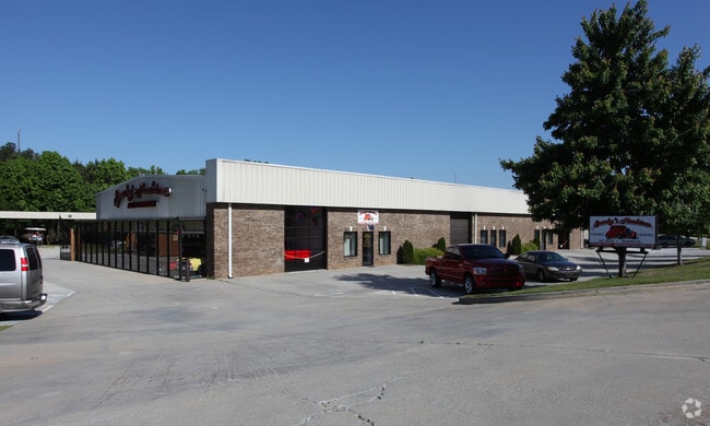
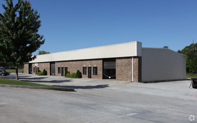
Property Record
1209 Nathan Blvd, Loganville, GA 30052


Save to a Folder
{{folder.Name}}
{{folder.ListingIds.length}} Properties
{{folder.ListingIds.length}} Property
Create a New Folder
Property Detail
1209 Nathan Blvd
C044000000013B00
#1 LOGANVILLE BUSINESS 3.69AC
Officebuilding
Walton
B3
Georgia
A Areas with a 1% annual chance of flooding and a 26% chance of flooding over the life of a 30-year mortgage.
1
2025
3.69 AC
2025
North Walton County
110503
Atlanta
9,000 SF
Atlanta-Sandy Springs-Roswell, GA
NEARBY LISTINGS FOR SALE OR LEASE
DEMOGRAPHICS near 1209 Nathan Blvd
1 mile
3 mile
5 mile
2025 Total Population
1,581
19,902
56,189
2030 Population
1,757
22,116
61,801
Pop Growth 2025-2030
+ 11.13%
+ 11.12%
+ 9.99%
Average Age
40
40
39
2025 Total Households
520
6,630
18,408
HH Growth 2025-2030
+ 11.15%
+ 11.15%
+ 10.12%
Median Household Inc
$87,028
$84,855
$96,018
Avg Household Size
3.00
2.90
3.00
2025 Avg HH Vehicles
2.00
2.00
2.00
Median Home Value
$365,185
$358,808
$363,610
Median Year Built
1999
1998
2001
Nearby Places
Map Layers
Map Styles
 Street
 Aerial
Layers
 Traffic
 Biking
Places
Listings with unknown addresses are not visible on the map
- Restaurants
- Banks
- Shops
- Fitness
- Groceries
PUBLIC TRANSPORTATION
AIRPORT
Hartsfield - Jackson Atlanta International
Drive
Walk
Distance
Hartsfield - Jackson Atlanta International
67 min
44.2 mi
Nearby Properties
Address
Land Use
TOTAL SIZE
Lot Size
Zoning
Address
Land Use
TOTAL SIZE
Lot Size
Zoning
197,044 SF
95.31 AC
A1
Address
Land Use
TOTAL SIZE
Lot Size
Zoning
3,480 SF
57.72 AC
RM8
Address
Land Use
TOTAL SIZE
Lot Size
Zoning
111,277 SF
17.36 AC
CH
Address
Land Use
TOTAL SIZE
Lot Size
Zoning
154,281 SF
45.25 AC
R44
Address
Land Use
TOTAL SIZE
Lot Size
Zoning
118,235 SF
31.54 AC
CH
Address
Land Use
TOTAL SIZE
Lot Size
Zoning
34,128 SF
61.26 AC
A1 B2 M1
Address
Land Use
TOTAL SIZE
Lot Size
Zoning
29,084 SF
19.19 AC
CH
Address
Land Use
TOTAL SIZE
Lot Size
Zoning
49,022 SF
23.15 AC
R22
Address
Land Use
TOTAL SIZE
Lot Size
Zoning
33,685 SF
17.71 AC
CH
Address
Land Use
TOTAL SIZE
Lot Size
Zoning
28,284 SF
6.45 AC
CN
Address
Land Use
TOTAL SIZE
Lot Size
Zoning
3,218 SF
12.46 AC
RM8
Address
Land Use
TOTAL SIZE
Lot Size
Zoning
21.78 AC
CH
Address
Land Use
TOTAL SIZE
Lot Size
Zoning
2,100 SF
25 AC
R44
Address
Land Use
TOTAL SIZE
Lot Size
Zoning
52,004 SF
5.89 AC
CH
Address
Land Use
TOTAL SIZE
Lot Size
Zoning
18,697 SF
8.68 AC
CH
Address
Land Use
TOTAL SIZE
Lot Size
Zoning
15,015 SF
8.80 AC
CH
Address
Land Use
TOTAL SIZE
Lot Size
Zoning
9,030 SF
63.75 AC
R44
Address
Land Use
TOTAL SIZE
Lot Size
Zoning
6,000 SF
25 AC
R44
Address
Land Use
TOTAL SIZE
Lot Size
Zoning
6,322 SF
1.85 AC
CH
Address
Land Use
TOTAL SIZE
Lot Size
Zoning
25,039 SF
3.05 AC
OI
Address
Land Use
TOTAL SIZE
Lot Size
Zoning
20.13 AC
CH
Address
Land Use
TOTAL SIZE
Lot Size
Zoning
2,894 SF
5.14 AC
RM8
Address
Land Use
TOTAL SIZE
Lot Size
Zoning
4,950 SF
6.96 AC
M1
Address
Land Use
TOTAL SIZE
Lot Size
Zoning
8,640 SF
53 AC
A1
Address
Land Use
TOTAL SIZE
Lot Size
Zoning
8.98 AC
CH
Address
Land Use
TOTAL SIZE
Lot Size
Zoning
12,800 SF
7.36 AC
B3
Address
Land Use
TOTAL SIZE
Lot Size
Zoning
15,226 SF
2.87 AC
CH
Address
Land Use
TOTAL SIZE
Lot Size
Zoning
79.91 AC
R22 OSC
Address
Land Use
TOTAL SIZE
Lot Size
Zoning
25,340 SF
7.59 AC
B1
Address
Land Use
TOTAL SIZE
Lot Size
Zoning
9,316 SF
2.40 AC
OI
The World's #1 Commercial Real Estate Marketplace
Connect with us
© 2026 CoStar Group
The information above has been obtained from sources believed reliable. While we do not doubt its accuracy we have not verified it and make no guarantee, warranty or representation about it. It is your responsibility to independently confirm its accuracy and completeness. Any projections, opinions, assumptions, or estimates used are for example only and do not represent the current or future performance of the property. The value of this transaction to you depends on tax and other factors which should be evaluated by your tax, financial, and legal advisors. You and your advisors should conduct a careful, independent investigation of the property to determine to your satisfaction the suitability of the property for your needs.