Property Record
12090 N Central Expy, Dallas, TX 75243

NEARBY LISTINGS FOR SALE OR LEASE
-
-
View all Dallas listings for sale on LoopNet.com
Property Detail
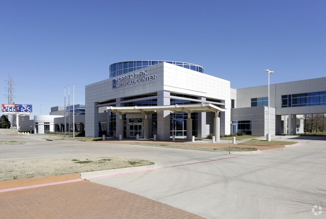
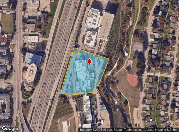
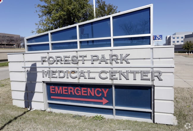
12090 N Central Expy
Dallas-Fort Worth-Arlington, TX
Forest Central 12
007748000A02D0000
FOREST CENTRAL 12 BLK A/7748 LOT 2D ACS 4.333 INT201600166231 DD06162016 CO-DC 7748 00A 02D00 7DA7748 00A
Hospitalpublic
Dallas
X
Texas
48113C0195K
2d
2024
4.33 AC
2025
East LBJ Freeway
019035
Dallas/Ft Worth
66,091 SF
DEMOGRAPHICS near 12090 N Central Expy
1 Mile
3 Mile
5 Mile
2024 Total Population
12,015
157,050
408,867
2029 Population
12,058
156,861
407,353
Pop Growth 2024-2029
+ 0.36%
(0.12%)
(0.37%)
Average Age
40
37
37
2024 Total Households
5,956
67,219
173,108
HH Growth 2024-2029
+ 0.29%
(0.22%)
(0.42%)
Median Household Inc
$71,385
$59,173
$67,679
Avg Household Size
1.90
2.30
2.30
2024 Avg HH Vehicles
1.00
2.00
2.00
Median Home Value
$478,947
$476,267
$446,908
Median Year Built
1990
1979
1979
Nearby Places
Map Layers
Map Styles
 Street
 Aerial
- Restaurants
- Banks
- Shops
- Fitness
- Groceries
PUBLIC TRANSPORTATION
TRANSIT/SUBWAY
Forest Lane (DART LIGHT RAIL - ORANGE LINE - Dallas Area Rapid Transit (DART), DART LIGHT RAIL - RED LINE - Dallas Area Rapid Transit (DART), Orange Line - Dallas Area Rapid Transit (DART), Red Line - Dallas Area Rapid Transit (DART))
DRIVE
WALK
Distance
Forest Lane (DART LIGHT RAIL - ORANGE LINE - Dallas Area Rapid Transit (DART), DART LIGHT RAIL - RED LINE - Dallas Area Rapid Transit (DART), Orange Line - Dallas Area Rapid Transit (DART), Red Line - Dallas Area Rapid Transit (DART))
4 min
14 min
0.7 mi
AIRPORT
Dallas Love Field
DRIVE
WALK
Distance
Dallas Love Field
20 min
10.9 mi
Dallas-Fort Worth International
DRIVE
WALK
Distance
Dallas-Fort Worth International
29 min
22.2 mi
Freight Ports
Port of Shreveport
DRIVE
WALK
Distance
Port of Shreveport
214 min
199.4 mi
Nearby Properties
Address
Land Use
TOTAL SIZE
Lot Size
Zoning
Address
Land Use
TOTAL SIZE
Lot Size
Zoning
3,240,143 SF
28.52 AC
Z151
Address
Land Use
TOTAL SIZE
Lot Size
Zoning
7,706,477 SF
245.55 AC
Z116
Address
Land Use
TOTAL SIZE
Lot Size
Zoning
2,186,362 SF
48.27 AC
Z239
Address
Land Use
TOTAL SIZE
Lot Size
Zoning
1,252,860 SF
57.08 AC
Z239
Address
Land Use
TOTAL SIZE
Lot Size
Zoning
3,423,779 SF
32.42 AC
Z151
Address
Land Use
TOTAL SIZE
Lot Size
Zoning
1,086,919 SF
5.85 AC
Z239
Address
Land Use
TOTAL SIZE
Lot Size
Zoning
557,392 SF
10.06 AC
Z239
Address
Land Use
TOTAL SIZE
Lot Size
Zoning
835,301 SF
9.29 AC
Z239
Address
Land Use
TOTAL SIZE
Lot Size
Zoning
421,798 SF
9 AC
Z151
Address
Land Use
TOTAL SIZE
Lot Size
Zoning
852,562 SF
13.86 AC
Z151
Address
Land Use
TOTAL SIZE
Lot Size
Zoning
706,061 SF
36.76 AC
Z109
Address
Land Use
TOTAL SIZE
Lot Size
Zoning
428,956 SF
18.76 AC
Z291
Address
Land Use
TOTAL SIZE
Lot Size
Zoning
485,067 SF
14.87 AC
Z239
Address
Land Use
TOTAL SIZE
Lot Size
Zoning
462,916 SF
15.67 AC
Z248
Address
Land Use
TOTAL SIZE
Lot Size
Zoning
249,692 SF
244.62 AC
Z239
Address
Land Use
TOTAL SIZE
Lot Size
Zoning
595,526 SF
6.92 AC
Z151
Address
Land Use
TOTAL SIZE
Lot Size
Zoning
379,592 SF
12.75 AC
Z248
Address
Land Use
TOTAL SIZE
Lot Size
Zoning
592,314 SF
4.19 AC
Z96
Address
Land Use
TOTAL SIZE
Lot Size
Zoning
456,300 SF
10.92 AC
Z239
Address
Land Use
TOTAL SIZE
Lot Size
Zoning
573,575 SF
6.43 AC
Z239
Address
Land Use
TOTAL SIZE
Lot Size
Zoning
227,323 SF
40.40 AC
Z239
Address
Land Use
TOTAL SIZE
Lot Size
Zoning
999,432 SF
5.78 AC
Z96
Address
Land Use
TOTAL SIZE
Lot Size
Zoning
424,666 SF
12.19 AC
Z151
Address
Land Use
TOTAL SIZE
Lot Size
Zoning
597,248 SF
6.61 AC
Z239
Address
Land Use
TOTAL SIZE
Lot Size
Zoning
316,085 SF
13.73 AC
Z107
Address
Land Use
TOTAL SIZE
Lot Size
Zoning
347,933 SF
12.61 AC
Z164
Address
Land Use
TOTAL SIZE
Lot Size
Zoning
278,210 SF
6.84 AC
Z248
Address
Land Use
TOTAL SIZE
Lot Size
Zoning
257,965 SF
15.96 AC
Z163
Address
Land Use
TOTAL SIZE
Lot Size
Zoning
479,179 SF
5 AC
Z151
Address
Land Use
TOTAL SIZE
Lot Size
Zoning
593,252 SF
8.50 AC
Z164
The World's #1 Commercial Real Estate Marketplace
Connect with us
© 2025 CoStar Group
The information above has been obtained from sources believed reliable. While we do not doubt its accuracy we have not verified it and make no guarantee, warranty or representation about it. It is your responsibility to independently confirm its accuracy and completeness. Any projections, opinions, assumptions, or estimates used are for example only and do not represent the current or future performance of the property. The value of this transaction to you depends on tax and other factors which should be evaluated by your tax, financial, and legal advisors. You and your advisors should conduct a careful, independent investigation of the property to determine to your satisfaction the suitability of the property for your needs.