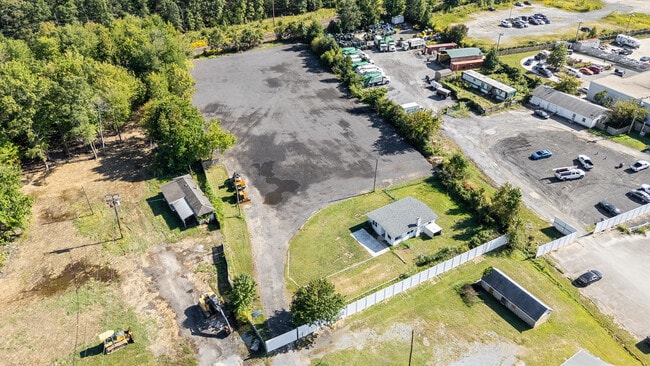
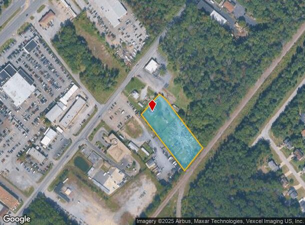
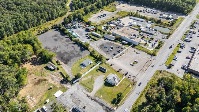
Property Record
12095 Hintze Pl, Waldorf, MD 20601
Current Lease Availabilities
NEARBY LISTINGS FOR SALE OR LEASE
Property Detail
12095 Hintze Pl
Washington-Arlington-Alexandria, DC-VA-MD-WV
Town Of La Plata
06-099394
LOT 1 = 1.741 AC SE RT 925 NW SI RR
Commercialnec
Charles
X
Maryland
24033C0345E
1
2025
1.74 AC
2025
Charles County
850802
Washington, DC
732 SF
DEMOGRAPHICS near 12095 Hintze Pl
1 Mile
3 Mile
5 Mile
2024 Total Population
8,410
41,781
92,331
2029 Population
8,801
43,369
95,892
Pop Growth 2024-2029
+ 4.65%
+ 3.80%
+ 3.86%
Average Age
36
38
38
2024 Total Households
3,167
15,298
32,903
HH Growth 2024-2029
+ 4.61%
+ 3.81%
+ 3.88%
Median Household Inc
$86,536
$94,586
$103,788
Avg Household Size
2.60
2.70
2.70
2024 Avg HH Vehicles
2.00
2.00
2.00
Median Home Value
$269,947
$330,798
$357,704
Median Year Built
1989
1988
1991
Nearby Places
- Restaurants
- Banks
- Shops
- Fitness
- Groceries
PUBLIC TRANSPORTATION
AIRPORT
Ronald Reagan Washington Ntl
DRIVE
WALK
Distance
Ronald Reagan Washington Ntl
42 min
25.5 mi
Washington Dulles International
DRIVE
WALK
Distance
Washington Dulles International
79 min
49.9 mi
Freight Ports
Port of Baltimore
DRIVE
WALK
Distance
Port of Baltimore
75 min
52.0 mi
Nearby Properties
Address
Land Use
TOTAL SIZE
Lot Size
Zoning
Address
Land Use
TOTAL SIZE
Lot Size
Zoning
7,670 SF
9.78 AC
TACC
Address
Land Use
TOTAL SIZE
Lot Size
Zoning
392,898 SF
36.37 AC
PRD
Address
Land Use
TOTAL SIZE
Lot Size
Zoning
617,760 SF
25.75 AC
IE
Address
Land Use
TOTAL SIZE
Lot Size
Zoning
477,958 SF
47.50 AC
CB
Address
Land Use
TOTAL SIZE
Lot Size
Zoning
312,478 SF
54.26 AC
PUD
Address
Land Use
TOTAL SIZE
Lot Size
Zoning
265,637 SF
54.72 AC
RH
Address
Land Use
TOTAL SIZE
Lot Size
Zoning
206,966 SF
32.61 AC
CB
Address
Land Use
TOTAL SIZE
Lot Size
Zoning
188,284 SF
9.02 AC
RM
Address
Land Use
TOTAL SIZE
Lot Size
Zoning
262,779 SF
26.84 AC
CB
Address
Land Use
TOTAL SIZE
Lot Size
Zoning
239,208 SF
13.51 AC
PUD
Address
Land Use
TOTAL SIZE
Lot Size
Zoning
177,540 SF
12.66 AC
WCD
Address
Land Use
TOTAL SIZE
Lot Size
Zoning
177,540 SF
27.64 AC
WCD
Address
Land Use
TOTAL SIZE
Lot Size
Zoning
167,075 SF
11.01 AC
RH
Address
Land Use
TOTAL SIZE
Lot Size
Zoning
237,903 SF
16.03 AC
PRD
Address
Land Use
TOTAL SIZE
Lot Size
Zoning
156,118 SF
17.01 AC
TACE
Address
Land Use
TOTAL SIZE
Lot Size
Zoning
62,838 SF
7.77 AC
TACE
Address
Land Use
TOTAL SIZE
Lot Size
Zoning
161,208 SF
10.99 AC
RH
Address
Land Use
TOTAL SIZE
Lot Size
Zoning
67,608 SF
4.01 AC
TACC
Address
Land Use
TOTAL SIZE
Lot Size
Zoning
160,985 SF
24.85 AC
CB
Address
Land Use
TOTAL SIZE
Lot Size
Zoning
98.41 AC
IH
Address
Land Use
TOTAL SIZE
Lot Size
Zoning
143,728 SF
19.71 AC
CB
Address
Land Use
TOTAL SIZE
Lot Size
Zoning
194,972 SF
59.84 AC
RH
Address
Land Use
TOTAL SIZE
Lot Size
Zoning
145,749 SF
20.15 AC
PUD
Address
Land Use
TOTAL SIZE
Lot Size
Zoning
132,745 SF
2.59 AC
CC
Address
Land Use
TOTAL SIZE
Lot Size
Zoning
118,880 SF
3.78 AC
PUD
Address
Land Use
TOTAL SIZE
Lot Size
Zoning
109,304 SF
9.09 AC
PUD
Address
Land Use
TOTAL SIZE
Lot Size
Zoning
84,240 SF
16.46 AC
PUD
Address
Land Use
TOTAL SIZE
Lot Size
Zoning
54,899 SF
5.23 AC
TACE
Address
Land Use
TOTAL SIZE
Lot Size
Zoning
128,909 SF
10.77 AC
TACE
Address
Land Use
TOTAL SIZE
Lot Size
Zoning
241,444 SF
10.76 AC
PUD
The World's #1 Commercial Real Estate Marketplace
Connect with us
© 2025 CoStar Group
The information above has been obtained from sources believed reliable. While we do not doubt its accuracy we have not verified it and make no guarantee, warranty or representation about it. It is your responsibility to independently confirm its accuracy and completeness. Any projections, opinions, assumptions, or estimates used are for example only and do not represent the current or future performance of the property. The value of this transaction to you depends on tax and other factors which should be evaluated by your tax, financial, and legal advisors. You and your advisors should conduct a careful, independent investigation of the property to determine to your satisfaction the suitability of the property for your needs.