Property Record
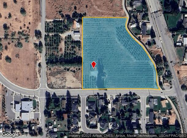
121 35Th St Nw, East Wenatchee, WA 98802
This Property Is For Sale
NEARBY LISTINGS FOR SALE OR LEASE
-
-
View all East Wenatchee listings for sale on LoopNet.com
Property Detail
121 35Th St Nw
Wenatchee, WA
East Wenatchee Land Companys Plat
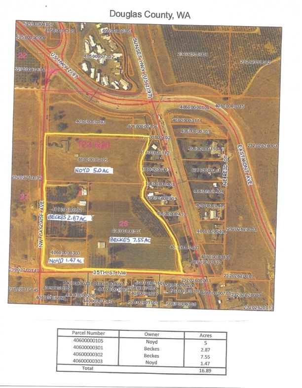
40-60-00-00301
E 9.8 OF W1/2 LOT 3; E1/2 LOT 3; LOT 4 BELOW CANAL; EX EASTMONT AVE EWLP 26-23-20; PER COMB #3139110
Agriculturalland
Douglas
2024
Washington
2025
3,4
950400
8.16 AC
2,475 SF
DEMOGRAPHICS near 121 35Th St Nw
1 Mile
3 Mile
5 Mile
2024 Total Population
2,427
27,777
70,473
2029 Population
2,602
29,151
73,714
Pop Growth 2024-2029
+ 7.21%
+ 4.95%
+ 4.60%
Average Age
45
41
40
2024 Total Households
958
10,834
26,309
HH Growth 2024-2029
+ 7.31%
+ 4.83%
+ 4.58%
Median Household Inc
$97,655
$73,622
$69,200
Avg Household Size
2.50
2.50
2.60
2024 Avg HH Vehicles
2.00
2.00
2.00
Median Home Value
$477,352
$406,107
$377,554
Median Year Built
2001
1991
1980
Nearby Places
- Restaurants
- Banks
- Shops
- Fitness
- Groceries
PUBLIC TRANSPORTATION
COMMUTER RAIL
Wenatchee Amtrak (Empire Builder - Amtrak)
DRIVE
WALK
Distance
Wenatchee Amtrak (Empire Builder - Amtrak)
11 min
5.3 mi
AIRPORT
Pangborn Memorial
DRIVE
WALK
Distance
Pangborn Memorial
18 min
8.9 mi
Freight Ports
Port of Everett
DRIVE
WALK
Distance
Port of Everett
171 min
122.4 mi
Nearby Properties
Address
Land Use
TOTAL SIZE
Lot Size
Zoning
Address
Land Use
TOTAL SIZE
Lot Size
Zoning
419,838 SF
14.62 AC
Address
Land Use
TOTAL SIZE
Lot Size
Zoning
309,324 SF
6.84 AC
Address
Land Use
TOTAL SIZE
Lot Size
Zoning
375,726 SF
30.12 AC
Address
Land Use
TOTAL SIZE
Lot Size
Zoning
198,833 SF
9.52 AC
Address
Land Use
TOTAL SIZE
Lot Size
Zoning
116,060 SF
6.44 AC
Address
Land Use
TOTAL SIZE
Lot Size
Zoning
197,755 SF
8.35 AC
R-M
Address
Land Use
TOTAL SIZE
Lot Size
Zoning
149,177 SF
2.55 AC
Address
Land Use
TOTAL SIZE
Lot Size
Zoning
134,669 SF
7.63 AC
Address
Land Use
TOTAL SIZE
Lot Size
Zoning
56,645 SF
6.35 AC
Address
Land Use
TOTAL SIZE
Lot Size
Zoning
91,804 SF
10.26 AC
Address
Land Use
TOTAL SIZE
Lot Size
Zoning
7,174 SF
14.47 AC
I-G
Address
Land Use
TOTAL SIZE
Lot Size
Zoning
104,070 SF
3.11 AC
Address
Land Use
TOTAL SIZE
Lot Size
Zoning
111,946 SF
2 AC
Address
Land Use
TOTAL SIZE
Lot Size
Zoning
73,830 SF
6.29 AC
Address
Land Use
TOTAL SIZE
Lot Size
Zoning
108,000 SF
7.05 AC
Address
Land Use
TOTAL SIZE
Lot Size
Zoning
65,430 SF
9 AC
Address
Land Use
TOTAL SIZE
Lot Size
Zoning
159,039 SF
16.21 AC
Address
Land Use
TOTAL SIZE
Lot Size
Zoning
57,520 SF
3.52 AC
Address
Land Use
TOTAL SIZE
Lot Size
Zoning
168,028 SF
21.20 AC
Address
Land Use
TOTAL SIZE
Lot Size
Zoning
148,977 SF
11.06 AC
Address
Land Use
TOTAL SIZE
Lot Size
Zoning
42,032 SF
4.27 AC
Address
Land Use
TOTAL SIZE
Lot Size
Zoning
67,932 SF
5.58 AC
Address
Land Use
TOTAL SIZE
Lot Size
Zoning
77,245 SF
21.02 AC
RR-20
Address
Land Use
TOTAL SIZE
Lot Size
Zoning
97,509 SF
5.71 AC
Address
Land Use
TOTAL SIZE
Lot Size
Zoning
142,150 SF
10.46 AC
Address
Land Use
TOTAL SIZE
Lot Size
Zoning
56,105 SF
6.03 AC
Address
Land Use
TOTAL SIZE
Lot Size
Zoning
89,736 SF
6.96 AC
Address
Land Use
TOTAL SIZE
Lot Size
Zoning
43,367 SF
1.50 AC
Address
Land Use
TOTAL SIZE
Lot Size
Zoning
94,989 SF
8.63 AC
Address
Land Use
TOTAL SIZE
Lot Size
Zoning
30,075 SF
5.82 AC
The World's #1 Commercial Real Estate Marketplace
Connect with us
© 2025 CoStar Group
The information above has been obtained from sources believed reliable. While we do not doubt its accuracy we have not verified it and make no guarantee, warranty or representation about it. It is your responsibility to independently confirm its accuracy and completeness. Any projections, opinions, assumptions, or estimates used are for example only and do not represent the current or future performance of the property. The value of this transaction to you depends on tax and other factors which should be evaluated by your tax, financial, and legal advisors. You and your advisors should conduct a careful, independent investigation of the property to determine to your satisfaction the suitability of the property for your needs.