Property Record
121 Route 9 Blvd, Berkeley, NJ 08741
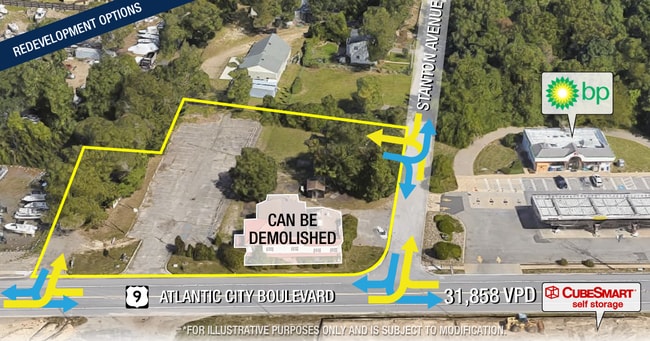
This Property Is For Sale
NEARBY LISTINGS FOR SALE OR LEASE
Property Detail
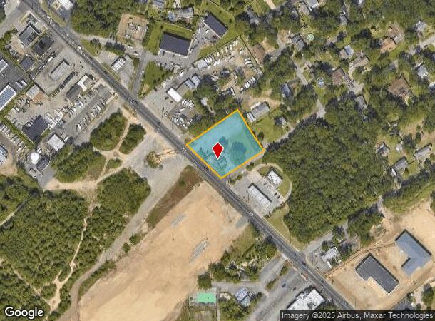
121 Route 9 Blvd
06-00870-01-00010
210X230
Commercialnec
Ocean
X
New Jersey
34029C0316F
10
2024
1.11 AC
2025
Ocean County
730000
Northern New Jersey
6,684 SF
New York-Jersey City-White Plains, NY-NJ
DEMOGRAPHICS near 121 Route 9 Blvd
1 Mile
3 Mile
5 Mile
2024 Total Population
6,862
63,568
118,234
2029 Population
7,255
67,462
125,673
Pop Growth 2024-2029
+ 5.73%
+ 6.13%
+ 6.29%
Average Age
39
39
41
2024 Total Households
2,438
22,646
44,302
HH Growth 2024-2029
+ 5.17%
+ 5.66%
+ 5.89%
Median Household Inc
$94,396
$87,136
$84,912
Avg Household Size
2.70
2.70
2.50
2024 Avg HH Vehicles
2.00
2.00
2.00
Median Home Value
$307,658
$301,895
$308,670
Median Year Built
1972
1974
1976
Nearby Places
- Restaurants
- Banks
- Shops
- Fitness
- Groceries
Nearby Properties
Address
Land Use
TOTAL SIZE
Lot Size
Zoning
Address
Land Use
TOTAL SIZE
Lot Size
Zoning
35,102 SF
139.33 AC
LI
Address
Land Use
TOTAL SIZE
Lot Size
Zoning
15.67 AC
RC
Address
Land Use
TOTAL SIZE
Lot Size
Zoning
44,584 SF
11.85 AC
VO
Address
Land Use
TOTAL SIZE
Lot Size
Zoning
165,024 SF
22.43 AC
HB
Address
Land Use
TOTAL SIZE
Lot Size
Zoning
8,118 SF
72.32 AC
R75
Address
Land Use
TOTAL SIZE
Lot Size
Zoning
8.21 AC
VO
Address
Land Use
TOTAL SIZE
Lot Size
Zoning
8,968 SF
26.36 AC
RMF
Address
Land Use
TOTAL SIZE
Lot Size
Zoning
31,302 SF
13.76 AC
EM18
Address
Land Use
TOTAL SIZE
Lot Size
Zoning
18,890 SF
24.59 AC
SPLT
Address
Land Use
TOTAL SIZE
Lot Size
Zoning
56,332 SF
8.85 AC
SPLT
Address
Land Use
TOTAL SIZE
Lot Size
Zoning
13,872 SF
22.96 AC
MF8
Address
Land Use
TOTAL SIZE
Lot Size
Zoning
2,549 SF
16.02 AC
RC
Address
Land Use
TOTAL SIZE
Lot Size
Zoning
44,394 SF
7.66 AC
EM18
Address
Land Use
TOTAL SIZE
Lot Size
Zoning
1,494 SF
17.30 AC
R200
Address
Land Use
TOTAL SIZE
Lot Size
Zoning
1,680 SF
14.33 AC
HB
Address
Land Use
TOTAL SIZE
Lot Size
Zoning
8.82 AC
O15
Address
Land Use
TOTAL SIZE
Lot Size
Zoning
9,343 SF
31.93 AC
SPLT
Address
Land Use
TOTAL SIZE
Lot Size
Zoning
103,750 SF
24.23 AC
R120
Address
Land Use
TOTAL SIZE
Lot Size
Zoning
33.59 AC
R90
Address
Land Use
TOTAL SIZE
Lot Size
Zoning
5,303 SF
2.14 AC
VO
Address
Land Use
TOTAL SIZE
Lot Size
Zoning
23.28 AC
R75
Address
Land Use
TOTAL SIZE
Lot Size
Zoning
22.29 AC
HB
Address
Land Use
TOTAL SIZE
Lot Size
Zoning
36,624 SF
3.15 AC
HMS
Address
Land Use
TOTAL SIZE
Lot Size
Zoning
9,267 SF
401.95 AC
RC
Address
Land Use
TOTAL SIZE
Lot Size
Zoning
3,524 SF
10 AC
HB
Address
Land Use
TOTAL SIZE
Lot Size
Zoning
4,102 SF
8 AC
HB
Address
Land Use
TOTAL SIZE
Lot Size
Zoning
22,908 SF
6.81 AC
EM10
Address
Land Use
TOTAL SIZE
Lot Size
Zoning
87,708 SF
22.90 AC
R90
Address
Land Use
TOTAL SIZE
Lot Size
Zoning
648 SF
9.52 AC
HB
Address
Land Use
TOTAL SIZE
Lot Size
Zoning
8,744 SF
8.70 AC
SAH2
The World's #1 Commercial Real Estate Marketplace
Connect with us
© 2025 CoStar Group
The information above has been obtained from sources believed reliable. While we do not doubt its accuracy we have not verified it and make no guarantee, warranty or representation about it. It is your responsibility to independently confirm its accuracy and completeness. Any projections, opinions, assumptions, or estimates used are for example only and do not represent the current or future performance of the property. The value of this transaction to you depends on tax and other factors which should be evaluated by your tax, financial, and legal advisors. You and your advisors should conduct a careful, independent investigation of the property to determine to your satisfaction the suitability of the property for your needs.