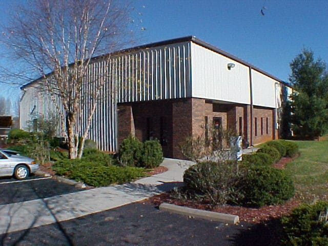
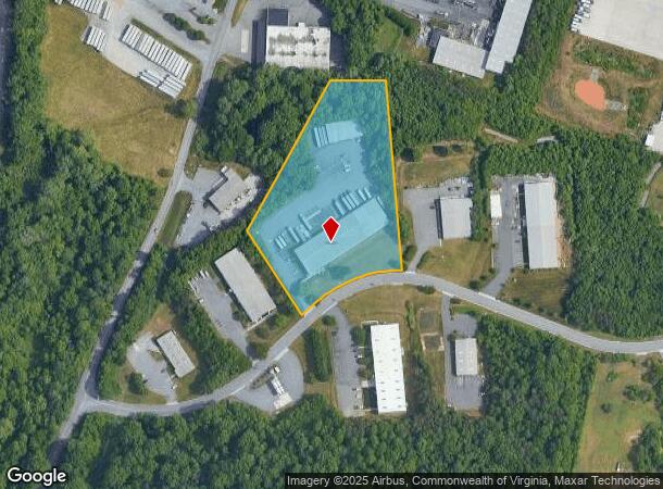
Property Record
121 Bradley Dr, Lynchburg, VA 24501
NEARBY LISTINGS FOR SALE OR LEASE
Property Detail
121 Bradley Dr
114-01-022
Odd Fellows Mayflower Area
Warehouse
BRADLEYTHORNHILL & LAND GROUP II, PARCEL 2B
X
Lynchburg City
51009C0395C
Virginia
2025
4.36 AC
2025
Montview
001400
Other Market Areas
27,000 SF
Lynchburg, VA
DEMOGRAPHICS near 121 Bradley Dr
1 Mile
3 Mile
5 Mile
2024 Total Population
1,603
37,557
80,790
2029 Population
1,610
37,739
81,278
Pop Growth 2024-2029
+ 0.44%
+ 0.48%
+ 0.60%
Average Age
28
35
37
2024 Total Households
345
14,783
33,375
HH Growth 2024-2029
0.00%
+ 0.49%
+ 0.64%
Median Household Inc
$49,687
$45,523
$51,658
Avg Household Size
2.20
2.20
2.20
2024 Avg HH Vehicles
2.00
2.00
2.00
Median Home Value
$125,000
$137,654
$167,978
Median Year Built
1960
1961
1971
Nearby Places
Map Layers
Map Styles
 Street
 Aerial
- Restaurants
- Banks
- Shops
- Fitness
- Groceries
PUBLIC TRANSPORTATION
COMMUTER RAIL
Lynchburg (Crescent - Amtrak, Northeast Regional - Amtrak)
DRIVE
WALK
Distance
Lynchburg (Crescent - Amtrak, Northeast Regional - Amtrak)
8 min
3.0 mi
AIRPORT
Lynchburg Regional/Preston Glenn Field
DRIVE
WALK
Distance
Lynchburg Regional/Preston Glenn Field
11 min
5.6 mi
Freight Ports
Virginia Port Authority - Richmond
DRIVE
WALK
Distance
Virginia Port Authority - Richmond
151 min
110.8 mi
Nearby Properties
Address
Land Use
TOTAL SIZE
Lot Size
Zoning
Address
Land Use
TOTAL SIZE
Lot Size
Zoning
1,116,411 SF
186.88 AC
B5
Address
Land Use
TOTAL SIZE
Lot Size
Zoning
686,112 SF
29.65 AC
B1R2
Address
Land Use
TOTAL SIZE
Lot Size
Zoning
816,228 SF
54.13 AC
B5I2
Address
Land Use
TOTAL SIZE
Lot Size
Zoning
814,428 SF
99.03 AC
212923
Address
Land Use
TOTAL SIZE
Lot Size
Zoning
353,180 SF
22.86 AC
B3
Address
Land Use
TOTAL SIZE
Lot Size
Zoning
323,985 SF
50.89 AC
2305
Address
Land Use
TOTAL SIZE
Lot Size
Zoning
400,209 SF
26.87 AC
B5
Address
Land Use
TOTAL SIZE
Lot Size
Zoning
326,293 SF
80.06 AC
R1R3
Address
Land Use
TOTAL SIZE
Lot Size
Zoning
Address
Land Use
TOTAL SIZE
Lot Size
Zoning
1,200 SF
73.13 AC
Address
Land Use
TOTAL SIZE
Lot Size
Zoning
163,760 SF
12 AC
Address
Land Use
TOTAL SIZE
Lot Size
Zoning
183,584 SF
2 AC
R4
Address
Land Use
TOTAL SIZE
Lot Size
Zoning
17,210 SF
14.35 AC
Address
Land Use
TOTAL SIZE
Lot Size
Zoning
8,259 SF
13.02 AC
Address
Land Use
TOTAL SIZE
Lot Size
Zoning
181,808 SF
39.61 AC
192921
Address
Land Use
TOTAL SIZE
Lot Size
Zoning
221,676 SF
102.07 AC
231529
Address
Land Use
TOTAL SIZE
Lot Size
Zoning
387,080 SF
18.30 AC
1509
Address
Land Use
TOTAL SIZE
Lot Size
Zoning
Address
Land Use
TOTAL SIZE
Lot Size
Zoning
86,855 SF
10.68 AC
B1
Address
Land Use
TOTAL SIZE
Lot Size
Zoning
284,151 SF
70.13 AC
I3
Address
Land Use
TOTAL SIZE
Lot Size
Zoning
1,241 SF
7.20 AC
2519
Address
Land Use
TOTAL SIZE
Lot Size
Zoning
10.13 AC
R4RC
Address
Land Use
TOTAL SIZE
Lot Size
Zoning
267,447 SF
28.46 AC
B3
Address
Land Use
TOTAL SIZE
Lot Size
Zoning
68,240 SF
20.56 AC
R4
Address
Land Use
TOTAL SIZE
Lot Size
Zoning
173,573 SF
8.80 AC
Address
Land Use
TOTAL SIZE
Lot Size
Zoning
103,515 SF
25.04 AC
B5R1
Address
Land Use
TOTAL SIZE
Lot Size
Zoning
91,070 SF
9.80 AC
B3
Address
Land Use
TOTAL SIZE
Lot Size
Zoning
290,213 SF
14.93 AC
I3
Address
Land Use
TOTAL SIZE
Lot Size
Zoning
10.84 AC
R4RC
Address
Land Use
TOTAL SIZE
Lot Size
Zoning
118,789 SF
1.90 AC
2501
The World's #1 Commercial Real Estate Marketplace
Connect with us
© 2025 CoStar Group
The information above has been obtained from sources believed reliable. While we do not doubt its accuracy we have not verified it and make no guarantee, warranty or representation about it. It is your responsibility to independently confirm its accuracy and completeness. Any projections, opinions, assumptions, or estimates used are for example only and do not represent the current or future performance of the property. The value of this transaction to you depends on tax and other factors which should be evaluated by your tax, financial, and legal advisors. You and your advisors should conduct a careful, independent investigation of the property to determine to your satisfaction the suitability of the property for your needs.