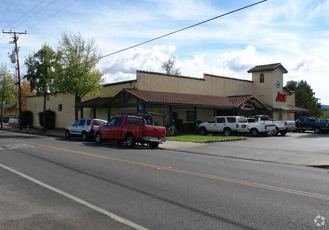
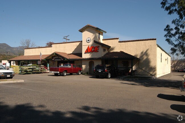
Property Record
121 E El Roblar Dr, Ojai, CA 93023

NEARBY LISTINGS FOR SALE OR LEASE
Property Detail
121 E El Roblar Dr
017-0-350-330
The Bard Subdivision Of The Rancho Ojai
Storebuilding
LOT 7
X
Ventura
06111C0559F
California
2024
0.96 AC
2025
Ojai/NW County
001002
Los Angeles
2,800 SF
Oxnard-Thousand Oaks-Ventura, CA
DEMOGRAPHICS near 121 E El Roblar Dr
1 mile
3 mile
5 mile
2024 Total Population
5,673
19,093
24,948
2029 Population
5,595
18,767
24,514
Pop Growth 2024-2029
(1.37%)
(1.71%)
(1.74%)
Average Age
45
46
46
2024 Total Households
2,190
7,555
9,754
HH Growth 2024-2029
(1.51%)
(1.87%)
(1.90%)
Median Household Inc
$88,381
$87,668
$89,612
Avg Household Size
2.50
2.40
2.50
2024 Avg HH Vehicles
2.00
2.00
2.00
Median Home Value
$694,682
$786,449
$794,490
Median Year Built
1967
1966
1966
Nearby Places
Map Layers
Map Styles
 Street
 Aerial
Transit
 Traffic
 Biking
Places
Listings with unknown addresses are not visible on the map
- Restaurants
- Banks
- Shops
- Fitness
- Groceries
PUBLIC TRANSPORTATION
AIRPORT
Santa Barbara Municipal
Drive
Walk
Distance
Santa Barbara Municipal
58 min
41.6 mi
Freight Ports
The Port of Hueneme
Drive
Walk
Distance
The Port of Hueneme
43 min
26.6 mi
Nearby Properties
Address
Land Use
TOTAL SIZE
Lot Size
Zoning
Address
Land Use
TOTAL SIZE
Lot Size
Zoning
182.91 AC
Address
Land Use
TOTAL SIZE
Lot Size
Zoning
6.23 AC
Address
Land Use
TOTAL SIZE
Lot Size
Zoning
2.01 AC
C1
Address
Land Use
TOTAL SIZE
Lot Size
Zoning
37,790 SF
5.13 AC
RPD-10U
Address
Land Use
TOTAL SIZE
Lot Size
Zoning
5,127 SF
4.66 AC
RO4
Address
Land Use
TOTAL SIZE
Lot Size
Zoning
25,301 SF
1.74 AC
BP
Address
Land Use
TOTAL SIZE
Lot Size
Zoning
15.91 AC
RPD-10U
Address
Land Use
TOTAL SIZE
Lot Size
Zoning
28.32 AC
RE20
Address
Land Use
TOTAL SIZE
Lot Size
Zoning
5.05 AC
CR
Address
Land Use
TOTAL SIZE
Lot Size
Zoning
534.56 AC
OS40AC
Address
Land Use
TOTAL SIZE
Lot Size
Zoning
4,900 SF
11.01 AC
Address
Land Use
TOTAL SIZE
Lot Size
Zoning
1.93 AC
CPD
Address
Land Use
TOTAL SIZE
Lot Size
Zoning
Address
Land Use
TOTAL SIZE
Lot Size
Zoning
2,696 SF
1.60 AC
RA2AC
Address
Land Use
TOTAL SIZE
Lot Size
Zoning
126.17 AC
OS20AC
Address
Land Use
TOTAL SIZE
Lot Size
Zoning
12.68 AC
PL
Address
Land Use
TOTAL SIZE
Lot Size
Zoning
4,635 SF
4.33 AC
RO4
Address
Land Use
TOTAL SIZE
Lot Size
Zoning
1,440 SF
98.32 AC
AE
Address
Land Use
TOTAL SIZE
Lot Size
Zoning
4,195 SF
2.21 AC
RO1
Address
Land Use
TOTAL SIZE
Lot Size
Zoning
1,028 SF
4.87 AC
Address
Land Use
TOTAL SIZE
Lot Size
Zoning
54,259 SF
2.56 AC
M1
Address
Land Use
TOTAL SIZE
Lot Size
Zoning
2,690 SF
0.80 AC
Address
Land Use
TOTAL SIZE
Lot Size
Zoning
3,550 SF
1.66 AC
RO1
Address
Land Use
TOTAL SIZE
Lot Size
Zoning
3,461 SF
2.15 AC
RA2AC
Address
Land Use
TOTAL SIZE
Lot Size
Zoning
5,314 SF
1.35 AC
RO1
Address
Land Use
TOTAL SIZE
Lot Size
Zoning
11.60 AC
RPD-6U
Address
Land Use
TOTAL SIZE
Lot Size
Zoning
9.70 AC
Address
Land Use
TOTAL SIZE
Lot Size
Zoning
7 AC
RA5AC
Address
Land Use
TOTAL SIZE
Lot Size
Zoning
15,668 SF
1.46 AC
CPD
Address
Land Use
TOTAL SIZE
Lot Size
Zoning
35,318 SF
2.59 AC
BP
The World's #1 Commercial Real Estate Marketplace
Connect with us
© 2026 CoStar Group
The information above has been obtained from sources believed reliable. While we do not doubt its accuracy we have not verified it and make no guarantee, warranty or representation about it. It is your responsibility to independently confirm its accuracy and completeness. Any projections, opinions, assumptions, or estimates used are for example only and do not represent the current or future performance of the property. The value of this transaction to you depends on tax and other factors which should be evaluated by your tax, financial, and legal advisors. You and your advisors should conduct a careful, independent investigation of the property to determine to your satisfaction the suitability of the property for your needs.