Property Record
121 E Tasman Dr, San Jose, CA 95134
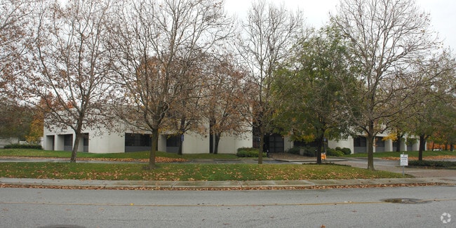


Property Detail
121 E Tasman Dr
097-07-072
LOT 1 RECORDER'S BOOK 849 PAGE 35
Multifamilydwelling
SANTA CLARA
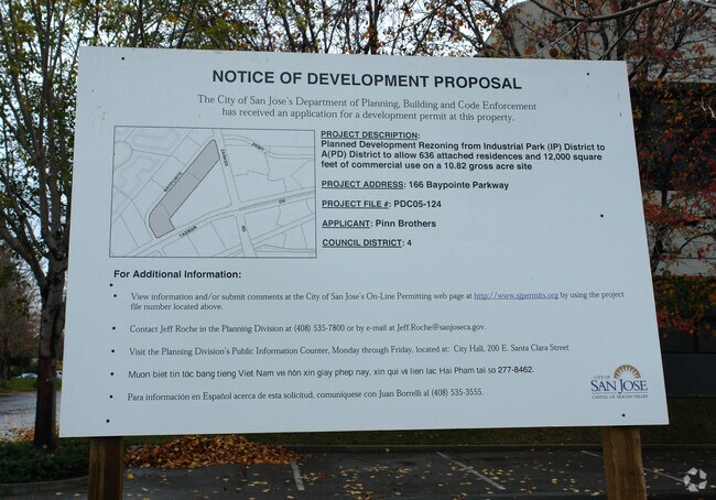
A(PD)
California
AH Areas with a 1% annual chance of shallow flooding, usually in the form of a pond, withan average depth ranging from 1 to 3 feet. These areas have a 26% chance of flooding over the life of a 30-year mortgage.
2.88 AC
2024
North San Jose
2025
South Bay/San Jose
505015
San Jose-Sunnyvale-Santa Clara, CA
302,921 SF
NEARBY LISTINGS FOR SALE OR LEASE
DEMOGRAPHICS near 121 E Tasman Dr
1 mile
3 mile
5 mile
2025 Total Population
24,448
105,222
352,537
2030 Population
24,999
108,357
361,637
Pop Growth 2025-2030
+ 2.25%
+ 2.98%
+ 2.58%
Average Age
33
36
38
2025 Total Households
10,873
39,158
121,812
HH Growth 2025-2030
+ 2.35%
+ 3.10%
+ 2.70%
Median Household Inc
$208,843
$197,792
$175,531
Avg Household Size
2.20
2.60
2.80
2025 Avg HH Vehicles
1.00
2.00
2.00
Median Home Value
$490,908
$1,073,322
$1,088,695
Median Year Built
2009
2004
1986
Nearby Places
Map Layers
Map Styles
 Street
 Aerial
Layers
 Traffic
 Biking
Places
Listings with unknown addresses are not visible on the map
- Restaurants
- Banks
- Shops
- Fitness
- Groceries
PUBLIC TRANSPORTATION
TRANSIT/SUBWAY
Baypointe Station (Alum Rock - Santa Teresa Line - Santa Clara VTA Light Rail)
Drive
Walk
Distance
Baypointe Station (Alum Rock - Santa Teresa Line - Santa Clara VTA Light Rail)
0 min
3 min
0.1 mi
Tasman Station (Alum Rock - Santa Teresa Line - Santa Clara VTA Light Rail, Mountain View - Winchester Line - Santa Clara VTA Light Rail)
Drive
Walk
Distance
Tasman Station (Alum Rock - Santa Teresa Line - Santa Clara VTA Light Rail, Mountain View - Winchester Line - Santa Clara VTA Light Rail)
2 min
8 min
0.4 mi
Champion Station (Mountain View - Winchester Line - Santa Clara VTA Light Rail)
Drive
Walk
Distance
Champion Station (Mountain View - Winchester Line - Santa Clara VTA Light Rail)
2 min
17 min
0.8 mi
Cisco Way Station (Alum Rock - Santa Teresa Line - Santa Clara VTA Light Rail)
Drive
Walk
Distance
Cisco Way Station (Alum Rock - Santa Teresa Line - Santa Clara VTA Light Rail)
2 min
15 min
0.8 mi
River Oaks Station (Alum Rock - Santa Teresa Line - Santa Clara VTA Light Rail, Mountain View - Winchester Line - Santa Clara VTA Light Rail)
Drive
Walk
Distance
River Oaks Station (Alum Rock - Santa Teresa Line - Santa Clara VTA Light Rail, Mountain View - Winchester Line - Santa Clara VTA Light Rail)
2 min
18 min
0.9 mi
COMMUTER RAIL
Drive
Walk
Distance
5 min
1.9 mi
Drive
Walk
Distance
11 min
5.6 mi
AIRPORT
Norman Y Mineta San Jose International
Drive
Walk
Distance
Norman Y Mineta San Jose International
10 min
4.8 mi
Metro Oakland International
Drive
Walk
Distance
Metro Oakland International
40 min
31.2 mi
San Francisco International
Drive
Walk
Distance
San Francisco International
41 min
32.0 mi
Freight Ports
Port of Redwood City
Drive
Walk
Distance
Port of Redwood City
26 min
18.9 mi
Nearby Properties
Address
Land Use
TOTAL SIZE
Lot Size
Zoning
Address
Land Use
TOTAL SIZE
Lot Size
Zoning
553,793 SF
38.06 AC
ML
Address
Land Use
TOTAL SIZE
Lot Size
Zoning
7.49 AC
M2
Address
Land Use
TOTAL SIZE
Lot Size
Zoning
194,597 SF
20.10 AC
I
Address
Land Use
TOTAL SIZE
Lot Size
Zoning
636,145 SF
9.44 AC
IP
Address
Land Use
TOTAL SIZE
Lot Size
Zoning
181,562 SF
16.51 AC
ML
Address
Land Use
TOTAL SIZE
Lot Size
Zoning
74,528 SF
9.26 AC
TEC
Address
Land Use
TOTAL SIZE
Lot Size
Zoning
818,051 SF
13.81 AC
CP
Address
Land Use
TOTAL SIZE
Lot Size
Zoning
1,282,514 SF
99.02 AC
C2-S
Address
Land Use
TOTAL SIZE
Lot Size
Zoning
242,320 SF
8.01 AC
TEC
Address
Land Use
TOTAL SIZE
Lot Size
Zoning
530,457 SF
6.71 AC
A(PD)
Address
Land Use
TOTAL SIZE
Lot Size
Zoning
107.73 AC
CT
Address
Land Use
TOTAL SIZE
Lot Size
Zoning
208,562 SF
9.10 AC
CP
Address
Land Use
TOTAL SIZE
Lot Size
Zoning
22.40 AC
PD
Address
Land Use
TOTAL SIZE
Lot Size
Zoning
22.40 AC
PD
Address
Land Use
TOTAL SIZE
Lot Size
Zoning
281,574 SF
32.09 AC
IP
Address
Land Use
TOTAL SIZE
Lot Size
Zoning
577,107 SF
3.65 AC
ML
Address
Land Use
TOTAL SIZE
Lot Size
Zoning
423,160 SF
6.24 AC
A(PD)
Address
Land Use
TOTAL SIZE
Lot Size
Zoning
50,774 SF
3.84 AC
MP
Address
Land Use
TOTAL SIZE
Lot Size
Zoning
556,649 SF
8.09 AC
IP
Address
Land Use
TOTAL SIZE
Lot Size
Zoning
104,960 SF
10.19 AC
IP
Address
Land Use
TOTAL SIZE
Lot Size
Zoning
500,000 SF
41.05 AC
MH
Address
Land Use
TOTAL SIZE
Lot Size
Zoning
605,915 SF
5.36 AC
APD
Address
Land Use
TOTAL SIZE
Lot Size
Zoning
130,306 SF
8.75 AC
ML
Address
Land Use
TOTAL SIZE
Lot Size
Zoning
143,644 SF
20.58 AC
PD-ML
Address
Land Use
TOTAL SIZE
Lot Size
Zoning
473,849 SF
6 AC
ML
Address
Land Use
TOTAL SIZE
Lot Size
Zoning
27,000 SF
2 AC
MH
Address
Land Use
TOTAL SIZE
Lot Size
Zoning
7.08 AC
IP
Address
Land Use
TOTAL SIZE
Lot Size
Zoning
446,996 SF
5.24 AC
ML
Address
Land Use
TOTAL SIZE
Lot Size
Zoning
329,907 SF
3.94 AC
A(PD)
Address
Land Use
TOTAL SIZE
Lot Size
Zoning
227,939 SF
2.72 AC
IP
The World's #1 Commercial Real Estate Marketplace
Connect with us
© 2026 CoStar Group
The information above has been obtained from sources believed reliable. While we do not doubt its accuracy we have not verified it and make no guarantee, warranty or representation about it. It is your responsibility to independently confirm its accuracy and completeness. Any projections, opinions, assumptions, or estimates used are for example only and do not represent the current or future performance of the property. The value of this transaction to you depends on tax and other factors which should be evaluated by your tax, financial, and legal advisors. You and your advisors should conduct a careful, independent investigation of the property to determine to your satisfaction the suitability of the property for your needs.