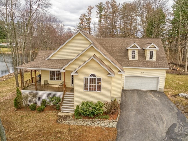
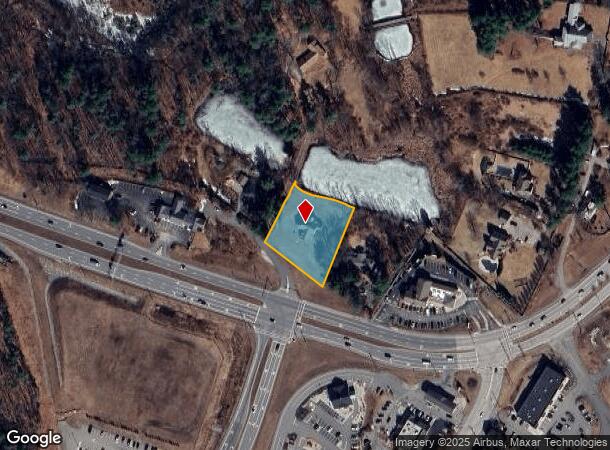
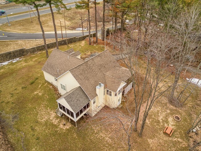
Property Record
121 Indian Rock Rd, Windham, NH 03087
NEARBY LISTINGS FOR SALE OR LEASE
Property Detail
121 Indian Rock Rd
Boston-Cambridge-Newton, MA-NH
Rockingham
WNDM-000012-A000000-000536
New Hampshire
Sfr
0.79 AC
X
Rockingham
33015C0545E
Boston
2,281 SF
DEMOGRAPHICS near 121 Indian Rock Rd
1 Mile
3 Mile
5 Mile
2024 Total Population
1,715
22,305
61,601
2029 Population
1,796
23,286
63,891
Pop Growth 2024-2029
+ 4.72%
+ 4.40%
+ 3.72%
Average Age
44
43
43
2024 Total Households
622
8,347
22,998
HH Growth 2024-2029
+ 4.82%
+ 4.52%
+ 3.79%
Median Household Inc
$136,218
$123,753
$120,319
Avg Household Size
2.70
2.60
2.60
2024 Avg HH Vehicles
2.00
2.00
2.00
Median Home Value
$676,957
$473,032
$444,302
Median Year Built
1987
1982
1982
Nearby Places
Map Layers
Map Styles
 Street
 Aerial
- Restaurants
- Banks
- Shops
- Fitness
- Groceries
PUBLIC TRANSPORTATION
AIRPORT
Manchester Boston Regional
DRIVE
WALK
Distance
Manchester Boston Regional
28 min
16.2 mi
General Edward Lawrence Logan International
DRIVE
WALK
Distance
General Edward Lawrence Logan International
50 min
37.9 mi
Portsmouth International at Pease
DRIVE
WALK
Distance
Portsmouth International at Pease
61 min
46.5 mi
Freight Ports
Port of Boston
DRIVE
WALK
Distance
Port of Boston
51 min
37.7 mi
SALE & LEASE HISTORY
LISTING DATE
SALE/LEASE

Jun 15, 2018
For Lease
Apr 11, 2017
For Sale
Apr 11, 2017
For Sale
Nearby Properties
Address
Land Use
TOTAL SIZE
Lot Size
Zoning
Address
Land Use
TOTAL SIZE
Lot Size
Zoning
8.37 AC
CIC
Address
Land Use
TOTAL SIZE
Lot Size
Zoning
273,035 SF
7.70 AC
CIC
Address
Land Use
TOTAL SIZE
Lot Size
Zoning
75.16 AC
CIB
Address
Land Use
TOTAL SIZE
Lot Size
Zoning
137,886 SF
26.65 AC
CIC
Address
Land Use
TOTAL SIZE
Lot Size
Zoning
72.18 AC
CIB
Address
Land Use
TOTAL SIZE
Lot Size
Zoning
297,592 SF
2.90 AC
CIC
Address
Land Use
TOTAL SIZE
Lot Size
Zoning
7.99 AC
CIB
Address
Land Use
TOTAL SIZE
Lot Size
Zoning
215,338 SF
66.52 AC
CIB
Address
Land Use
TOTAL SIZE
Lot Size
Zoning
50,048 SF
8.81 AC
CIB
Address
Land Use
TOTAL SIZE
Lot Size
Zoning
13,158 SF
52.40 AC
VCD
Address
Land Use
TOTAL SIZE
Lot Size
Zoning
113,388 SF
16.28 AC
CIB
Address
Land Use
TOTAL SIZE
Lot Size
Zoning
Address
Land Use
TOTAL SIZE
Lot Size
Zoning
21.88 AC
CIC
Address
Land Use
TOTAL SIZE
Lot Size
Zoning
Address
Land Use
TOTAL SIZE
Lot Size
Zoning
66,543 SF
6.74 AC
CIB
Address
Land Use
TOTAL SIZE
Lot Size
Zoning
71,854 SF
26 AC
RD
Address
Land Use
TOTAL SIZE
Lot Size
Zoning
21.56 AC
CIB
Address
Land Use
TOTAL SIZE
Lot Size
Zoning
155,040 SF
16.36 AC
IND
Address
Land Use
TOTAL SIZE
Lot Size
Zoning
38,168 SF
5 AC
CIC
Address
Land Use
TOTAL SIZE
Lot Size
Zoning
21,433 SF
7.54 AC
LID
Address
Land Use
TOTAL SIZE
Lot Size
Zoning
14.02 AC
CIC
Address
Land Use
TOTAL SIZE
Lot Size
Zoning
63,628 SF
34.21 AC
CDA
Address
Land Use
TOTAL SIZE
Lot Size
Zoning
11.49 AC
CIB
Address
Land Use
TOTAL SIZE
Lot Size
Zoning
59,565 SF
41.20 AC
RD
Address
Land Use
TOTAL SIZE
Lot Size
Zoning
55,980 SF
2.08 AC
TCD
Address
Land Use
TOTAL SIZE
Lot Size
Zoning
46,991 SF
5.68 AC
CIB
Address
Land Use
TOTAL SIZE
Lot Size
Zoning
46,389 SF
8.06 AC
B1
Address
Land Use
TOTAL SIZE
Lot Size
Zoning
19,920 SF
15 AC
PBT
Address
Land Use
TOTAL SIZE
Lot Size
Zoning
3.90 AC
CA
Address
Land Use
TOTAL SIZE
Lot Size
Zoning
68,175 SF
6.54 AC
CIC
The World's #1 Commercial Real Estate Marketplace
Connect with us
© 2026 CoStar Group
The information above has been obtained from sources believed reliable. While we do not doubt its accuracy we have not verified it and make no guarantee, warranty or representation about it. It is your responsibility to independently confirm its accuracy and completeness. Any projections, opinions, assumptions, or estimates used are for example only and do not represent the current or future performance of the property. The value of this transaction to you depends on tax and other factors which should be evaluated by your tax, financial, and legal advisors. You and your advisors should conduct a careful, independent investigation of the property to determine to your satisfaction the suitability of the property for your needs.