Property Record
121 Linton Rd, Benton, LA 71006
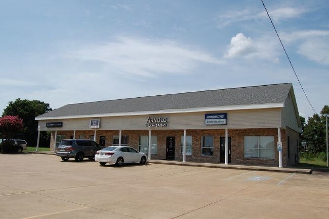

Property Detail
121 Linton Rd
104150
FROM THE NE COR. OF SEC. 16 RUN W. 2052.95 FT. THENCE S. 2784.90 FT. TO PT. OF BEGIN. THENCE S. 27 DEG. 48 MIN. 26 SEC. E. 25
Storebuilding
Bossier
AE The base floodplain where base flood elevations are provided. AE Zones are now used on new format FIRMs instead of A1-A30 Zones.
Louisiana
2024
4 AC
2024
Bossier Parish
011116
Shreveport/Bossier City
2,700 SF
Shreveport-Bossier City, LA
NEARBY LISTINGS FOR SALE OR LEASE
-
-
View all Benton listings for lease on LoopNet.com
DEMOGRAPHICS near 121 Linton Rd
1 mile
3 mile
5 mile
2025 Total Population
3,901
18,457
30,558
2030 Population
3,970
18,799
31,062
Pop Growth 2025-2030
+ 1.77%
+ 1.85%
+ 1.65%
Average Age
36
38
40
2025 Total Households
1,330
6,597
11,393
HH Growth 2025-2030
+ 1.95%
+ 1.97%
+ 1.72%
Median Household Inc
$97,233
$96,686
$93,747
Avg Household Size
2.90
2.80
2.60
2025 Avg HH Vehicles
2.00
2.00
2.00
Median Home Value
$357,941
$347,450
$326,871
Median Year Built
2008
2007
2003
Nearby Places
Map Layers
Map Styles
 Street
 Aerial
Transit
 Traffic
 Biking
Places
Listings with unknown addresses are not visible on the map
- Restaurants
- Banks
- Shops
- Fitness
- Groceries
PUBLIC TRANSPORTATION
AIRPORT
Shreveport Regional
Drive
Walk
Distance
Shreveport Regional
34 min
21.7 mi
Freight Ports
Port of Shreveport
Drive
Walk
Distance
Port of Shreveport
40 min
23.8 mi
SALE & LEASE HISTORY
LISTING DATE
SALE/LEASE

Aug 12, 2019
For Lease
Nearby Properties
Address
Land Use
TOTAL SIZE
Lot Size
Zoning
Address
Land Use
TOTAL SIZE
Lot Size
Zoning
Address
Land Use
TOTAL SIZE
Lot Size
Zoning
5,152 SF
24 AC
Address
Land Use
TOTAL SIZE
Lot Size
Zoning
87,000 SF
Address
Land Use
TOTAL SIZE
Lot Size
Zoning
55,689 SF
Address
Land Use
TOTAL SIZE
Lot Size
Zoning
22,850 SF
7.83 AC
Address
Land Use
TOTAL SIZE
Lot Size
Zoning
33,020 SF
107.07 AC
Address
Land Use
TOTAL SIZE
Lot Size
Zoning
46,493 SF
20 AC
Address
Land Use
TOTAL SIZE
Lot Size
Zoning
64,000 SF
15 AC
Address
Land Use
TOTAL SIZE
Lot Size
Zoning
14,144 SF
155 AC
Address
Land Use
TOTAL SIZE
Lot Size
Zoning
90,850 SF
2 AC
Address
Land Use
TOTAL SIZE
Lot Size
Zoning
36,100 SF
14 AC
Address
Land Use
TOTAL SIZE
Lot Size
Zoning
12,325 SF
11 AC
Address
Land Use
TOTAL SIZE
Lot Size
Zoning
18,225 SF
4 AC
Address
Land Use
TOTAL SIZE
Lot Size
Zoning
70,000 SF
4 AC
Address
Land Use
TOTAL SIZE
Lot Size
Zoning
4,000 SF
3 AC
Address
Land Use
TOTAL SIZE
Lot Size
Zoning
32,700 SF
6 AC
Address
Land Use
TOTAL SIZE
Lot Size
Zoning
9,308 SF
0.21 AC
Address
Land Use
TOTAL SIZE
Lot Size
Zoning
4,274 SF
1.66 AC
Address
Land Use
TOTAL SIZE
Lot Size
Zoning
12,902 SF
0.17 AC
Address
Land Use
TOTAL SIZE
Lot Size
Zoning
7,971 SF
2.14 AC
Address
Land Use
TOTAL SIZE
Lot Size
Zoning
6,890 SF
0.01 AC
Address
Land Use
TOTAL SIZE
Lot Size
Zoning
32,790 SF
Address
Land Use
TOTAL SIZE
Lot Size
Zoning
23,700 SF
23 AC
Address
Land Use
TOTAL SIZE
Lot Size
Zoning
2,485 SF
Address
Land Use
TOTAL SIZE
Lot Size
Zoning
16,882 SF
16.89 AC
Address
Land Use
TOTAL SIZE
Lot Size
Zoning
9,218 SF
2.88 AC
Address
Land Use
TOTAL SIZE
Lot Size
Zoning
2,880 SF
0.96 AC
Address
Land Use
TOTAL SIZE
Lot Size
Zoning
9,008 SF
4 AC
Address
Land Use
TOTAL SIZE
Lot Size
Zoning
4,300 SF
0.50 AC
Address
Land Use
TOTAL SIZE
Lot Size
Zoning
10,108 SF
The World's #1 Commercial Real Estate Marketplace
Connect with us
© 2026 CoStar Group
The information above has been obtained from sources believed reliable. While we do not doubt its accuracy we have not verified it and make no guarantee, warranty or representation about it. It is your responsibility to independently confirm its accuracy and completeness. Any projections, opinions, assumptions, or estimates used are for example only and do not represent the current or future performance of the property. The value of this transaction to you depends on tax and other factors which should be evaluated by your tax, financial, and legal advisors. You and your advisors should conduct a careful, independent investigation of the property to determine to your satisfaction the suitability of the property for your needs.