Property Record
121 Main St S, Braham, MN 55006
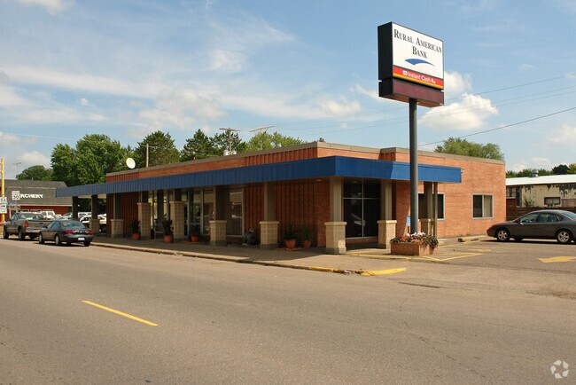

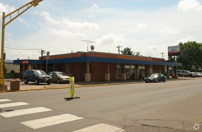
Property Detail
121 Main St S
14.002.1701
PT SW/4 OF NE/4 DESC AS: BEG AT INTERSECTION OF LINE LL WITH & 100' NWLY FROM CENTER LINE OF RR & SLY LINE OF RUSH CITY RD; SWLY LL WITH CENTER LINE OF RR 100' NWLY THEREFROM FOR 250'; SELY 80' TO PT 20' NWLY FROM CENTER LINE OF RR; NELY LL TO CENTER
Multipleuses
ISANTI
B and X Area of moderate flood hazard, usually the area between the limits of the 100-year and 500-year floods.
Minnesota
2026
0.53 AC
2025
Isanti County
130200
Minneapolis/St Paul
4,000 SF
Minneapolis-St. Paul-Bloomington, MN-WI
NEARBY LISTINGS FOR SALE OR LEASE
-
-
View all Braham listings for sale on LoopNet.com
DEMOGRAPHICS near 121 Main St S
1 mile
3 mile
5 mile
2025 Total Population
1,948
2,524
4,446
2030 Population
2,027
2,613
4,581
Pop Growth 2025-2030
+ 4.06%
+ 3.53%
+ 3.04%
Average Age
37
38
41
2025 Total Households
787
1,009
1,764
HH Growth 2025-2030
+ 4.07%
+ 3.67%
+ 3.12%
Median Household Inc
$56,123
$58,924
$68,553
Avg Household Size
2.50
2.50
2.50
2025 Avg HH Vehicles
2.00
2.00
2.00
Median Home Value
$192,179
$210,919
$256,395
Median Year Built
1978
1977
1977
Nearby Places
Map Layers
Map Styles
 Street
 Aerial
Layers
 Traffic
 Biking
Places
Listings with unknown addresses are not visible on the map
- Restaurants
- Banks
- Shops
- Fitness
- Groceries
Nearby Properties
Address
Land Use
TOTAL SIZE
Lot Size
Zoning
Address
Land Use
TOTAL SIZE
Lot Size
Zoning
30,934 SF
3.22 AC
Address
Land Use
TOTAL SIZE
Lot Size
Zoning
18,600 SF
9.95 AC
Address
Land Use
TOTAL SIZE
Lot Size
Zoning
40,548 SF
0.70 AC
Address
Land Use
TOTAL SIZE
Lot Size
Zoning
21,174 SF
7.91 AC
Address
Land Use
TOTAL SIZE
Lot Size
Zoning
50,430 SF
5.58 AC
Address
Land Use
TOTAL SIZE
Lot Size
Zoning
15,119 SF
9.18 AC
Address
Land Use
TOTAL SIZE
Lot Size
Zoning
15,478 SF
0.86 AC
Address
Land Use
TOTAL SIZE
Lot Size
Zoning
33,975 SF
8.74 AC
Address
Land Use
TOTAL SIZE
Lot Size
Zoning
11,200 SF
0.32 AC
Address
Land Use
TOTAL SIZE
Lot Size
Zoning
56,000 SF
10.05 AC
I
Address
Land Use
TOTAL SIZE
Lot Size
Zoning
1,786 SF
0.96 AC
Address
Land Use
TOTAL SIZE
Lot Size
Zoning
185.80 AC
Address
Land Use
TOTAL SIZE
Lot Size
Zoning
5,709 SF
0.52 AC
Address
Land Use
TOTAL SIZE
Lot Size
Zoning
3,600 SF
1.07 AC
Address
Land Use
TOTAL SIZE
Lot Size
Zoning
2,834 SF
0.41 AC
Address
Land Use
TOTAL SIZE
Lot Size
Zoning
6,020 SF
2.61 AC
Address
Land Use
TOTAL SIZE
Lot Size
Zoning
9,240 SF
2.50 AC
Address
Land Use
TOTAL SIZE
Lot Size
Zoning
169.08 AC
Address
Land Use
TOTAL SIZE
Lot Size
Zoning
21.93 AC
Address
Land Use
TOTAL SIZE
Lot Size
Zoning
225.50 AC
AG
Address
Land Use
TOTAL SIZE
Lot Size
Zoning
1,319 SF
80 AC
AG
Address
Land Use
TOTAL SIZE
Lot Size
Zoning
9,000 SF
2.51 AC
B
Address
Land Use
TOTAL SIZE
Lot Size
Zoning
1,040 SF
16 AC
AG
Address
Land Use
TOTAL SIZE
Lot Size
Zoning
1,150 SF
24.64 AC
AG
Address
Land Use
TOTAL SIZE
Lot Size
Zoning
6,528 SF
0.13 AC
Address
Land Use
TOTAL SIZE
Lot Size
Zoning
3,410 SF
0.93 AC
The World's #1 Commercial Real Estate Marketplace
Connect with us
© 2026 CoStar Group
The information above has been obtained from sources believed reliable. While we do not doubt its accuracy we have not verified it and make no guarantee, warranty or representation about it. It is your responsibility to independently confirm its accuracy and completeness. Any projections, opinions, assumptions, or estimates used are for example only and do not represent the current or future performance of the property. The value of this transaction to you depends on tax and other factors which should be evaluated by your tax, financial, and legal advisors. You and your advisors should conduct a careful, independent investigation of the property to determine to your satisfaction the suitability of the property for your needs.