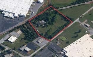
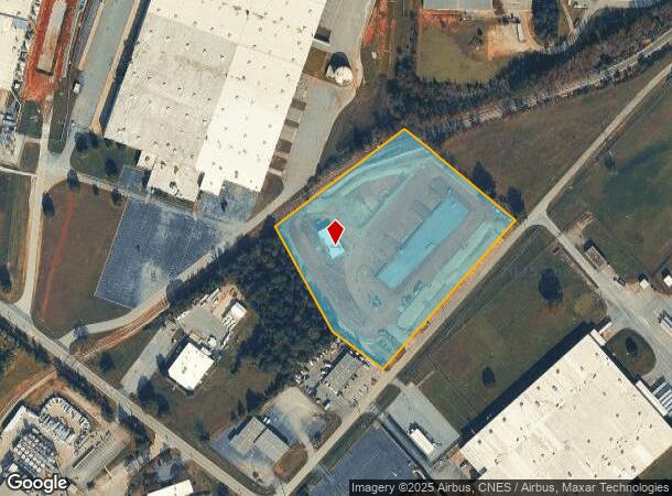
Property Record
117 Osage Dr, Greenville, SC 29605
NEARBY LISTINGS FOR SALE OR LEASE
Property Detail
117 Osage Dr
Greenville-Anderson-Mauldin, SC
Crucible Chemical Co Inc
0400.01-01-114.00
MAP 0400.01
Recreationalentertainmentgeneral
Greenville
X
South Carolina
45045C0476E
114.00
2024
6 AC
2024
Western Greenville County
003401
Greenville/Spartanburg
DEMOGRAPHICS near 117 Osage Dr
1 Mile
3 Mile
5 Mile
2024 Total Population
616
16,378
71,840
2029 Population
679
18,235
80,057
Pop Growth 2024-2029
+ 10.23%
+ 11.34%
+ 11.44%
Average Age
37
38
39
2024 Total Households
230
6,073
27,746
HH Growth 2024-2029
+ 10.43%
+ 11.35%
+ 11.54%
Median Household Inc
$52,631
$60,922
$62,373
Avg Household Size
2.60
2.60
2.50
2024 Avg HH Vehicles
2.00
2.00
2.00
Median Home Value
$205,172
$163,920
$203,919
Median Year Built
1978
1995
1994
Nearby Places
- Restaurants
- Banks
- Shops
- Fitness
- Groceries
PUBLIC TRANSPORTATION
AIRPORT
Greenville Spartanburg International
DRIVE
WALK
Distance
Greenville Spartanburg International
30 min
19.9 mi
Freight Ports
North Charleston Terminal
DRIVE
WALK
Distance
North Charleston Terminal
225 min
198.6 mi
SALE & LEASE HISTORY
LISTING DATE
SALE/LEASE

Sep 24, 2016
For Sale
Nearby Properties
Address
Land Use
TOTAL SIZE
Lot Size
Zoning
Address
Land Use
TOTAL SIZE
Lot Size
Zoning
78.04 AC
C2
Address
Land Use
TOTAL SIZE
Lot Size
Zoning
977.33 AC
I1
Address
Land Use
TOTAL SIZE
Lot Size
Zoning
46.07 AC
I2
Address
Land Use
TOTAL SIZE
Lot Size
Zoning
29.91 AC
Address
Land Use
TOTAL SIZE
Lot Size
Zoning
32.34 AC
Address
Land Use
TOTAL SIZE
Lot Size
Zoning
58.95 AC
Address
Land Use
TOTAL SIZE
Lot Size
Zoning
41.48 AC
I2
Address
Land Use
TOTAL SIZE
Lot Size
Zoning
12.87 AC
I2
Address
Land Use
TOTAL SIZE
Lot Size
Zoning
14.13 AC
Address
Land Use
TOTAL SIZE
Lot Size
Zoning
387.84 AC
S1
Address
Land Use
TOTAL SIZE
Lot Size
Zoning
31.52 AC
I2
Address
Land Use
TOTAL SIZE
Lot Size
Zoning
8.97 AC
Address
Land Use
TOTAL SIZE
Lot Size
Zoning
13.90 AC
I1
Address
Land Use
TOTAL SIZE
Lot Size
Zoning
33.60 AC
I1
Address
Land Use
TOTAL SIZE
Lot Size
Zoning
13.52 AC
I2
Address
Land Use
TOTAL SIZE
Lot Size
Zoning
28.29 AC
I2
Address
Land Use
TOTAL SIZE
Lot Size
Zoning
12.41 AC
RS
Address
Land Use
TOTAL SIZE
Lot Size
Zoning
385.69 AC
R10
Address
Land Use
TOTAL SIZE
Lot Size
Zoning
Address
Land Use
TOTAL SIZE
Lot Size
Zoning
12.85 AC
I1
Address
Land Use
TOTAL SIZE
Lot Size
Zoning
50 AC
I2
Address
Land Use
TOTAL SIZE
Lot Size
Zoning
13.36 AC
I1
Address
Land Use
TOTAL SIZE
Lot Size
Zoning
11 AC
I1
Address
Land Use
TOTAL SIZE
Lot Size
Zoning
128.50 AC
I1
Address
Land Use
TOTAL SIZE
Lot Size
Zoning
45.10 AC
I1
Address
Land Use
TOTAL SIZE
Lot Size
Zoning
23.10 AC
S1
Address
Land Use
TOTAL SIZE
Lot Size
Zoning
12.84 AC
S1
Address
Land Use
TOTAL SIZE
Lot Size
Zoning
91.92 AC
I1
Address
Land Use
TOTAL SIZE
Lot Size
Zoning
8.14 AC
I1
Address
Land Use
TOTAL SIZE
Lot Size
Zoning
75.52 AC
I1
The World's #1 Commercial Real Estate Marketplace
Connect with us
© 2025 CoStar Group
The information above has been obtained from sources believed reliable. While we do not doubt its accuracy we have not verified it and make no guarantee, warranty or representation about it. It is your responsibility to independently confirm its accuracy and completeness. Any projections, opinions, assumptions, or estimates used are for example only and do not represent the current or future performance of the property. The value of this transaction to you depends on tax and other factors which should be evaluated by your tax, financial, and legal advisors. You and your advisors should conduct a careful, independent investigation of the property to determine to your satisfaction the suitability of the property for your needs.