Property Record
121 Sparkleberry Crossing Rd, Columbia, SC 29229
NEARBY LISTINGS FOR SALE OR LEASE
Property Detail
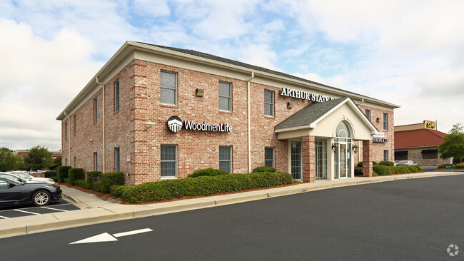
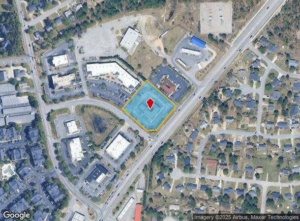
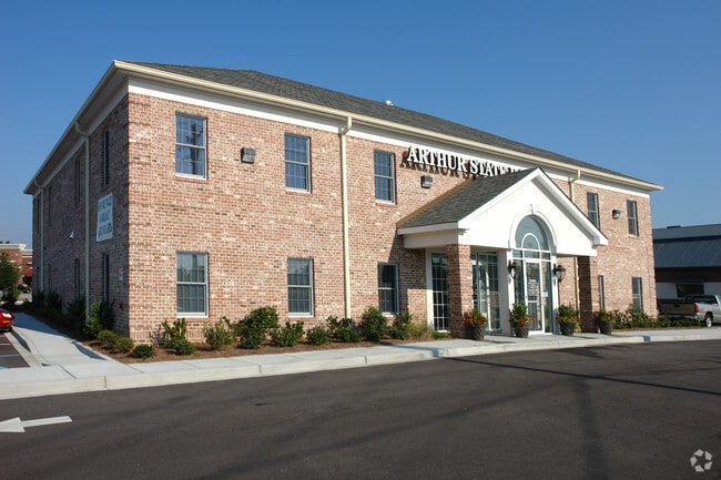
121 Sparkleberry Crossing Rd
Columbia, SC
Sparkleberry Crossings
25705-07-28
LOT 6 207.9X9.6X248X257.7X205.5X60 #SU SPARKLEBERRY CROSSING #PR RB589-1926
Commercialnec
Richland
X
South Carolina
45079C0276L
6,207
2025
1.46 AC
2024
Northeast Columbia
011414
Columbia
13,189 SF
DEMOGRAPHICS near 121 Sparkleberry Crossing Rd
1 Mile
3 Mile
5 Mile
2024 Total Population
4,052
30,637
78,279
2029 Population
4,075
31,241
79,484
Pop Growth 2024-2029
+ 0.57%
+ 1.97%
+ 1.54%
Average Age
39
39
39
2024 Total Households
1,654
12,511
30,961
HH Growth 2024-2029
+ 0.60%
+ 2.12%
+ 1.60%
Median Household Inc
$79,366
$72,577
$67,002
Avg Household Size
2.40
2.40
2.50
2024 Avg HH Vehicles
2.00
2.00
2.00
Median Home Value
$247,674
$266,291
$201,705
Median Year Built
1996
2000
1998
Nearby Places
- Restaurants
- Banks
- Shops
- Fitness
- Groceries
PUBLIC TRANSPORTATION
AIRPORT
Columbia Metro
DRIVE
WALK
Distance
Columbia Metro
42 min
25.4 mi
SALE & LEASE HISTORY
LISTING DATE
SALE/LEASE

Sep 25, 2016
For Lease
Dec 29, 2016
For Lease
Nearby Properties
Address
Land Use
TOTAL SIZE
Lot Size
Zoning
Address
Land Use
TOTAL SIZE
Lot Size
Zoning
3,293 SF
20.78 AC
GC
Address
Land Use
TOTAL SIZE
Lot Size
Zoning
333,002 SF
8.39 AC
GC
Address
Land Use
TOTAL SIZE
Lot Size
Zoning
298,100 SF
74.42 AC
C-3
Address
Land Use
TOTAL SIZE
Lot Size
Zoning
244,269 SF
9.54 AC
GC
Address
Land Use
TOTAL SIZE
Lot Size
Zoning
563.44 AC
OI
Address
Land Use
TOTAL SIZE
Lot Size
Zoning
343,506 SF
29.94 AC
RM-HD
Address
Land Use
TOTAL SIZE
Lot Size
Zoning
329,677 SF
17.12 AC
PDD
Address
Land Use
TOTAL SIZE
Lot Size
Zoning
313,664 SF
33.91 AC
RG-2
Address
Land Use
TOTAL SIZE
Lot Size
Zoning
298,080 SF
18.10 AC
RU
Address
Land Use
TOTAL SIZE
Lot Size
Zoning
285,368 SF
16.09 AC
GC
Address
Land Use
TOTAL SIZE
Lot Size
Zoning
299,353 SF
12.36 AC
GC
Address
Land Use
TOTAL SIZE
Lot Size
Zoning
140,567 SF
16.98 AC
M-1
Address
Land Use
TOTAL SIZE
Lot Size
Zoning
210,926 SF
22 AC
HI
Address
Land Use
TOTAL SIZE
Lot Size
Zoning
62,878 SF
8.43 AC
RM-HD
Address
Land Use
TOTAL SIZE
Lot Size
Zoning
360,163 SF
20.11 AC
RM-MD
Address
Land Use
TOTAL SIZE
Lot Size
Zoning
245,825 SF
11 AC
RS-2
Address
Land Use
TOTAL SIZE
Lot Size
Zoning
91,672 SF
12.18 AC
GC
Address
Land Use
TOTAL SIZE
Lot Size
Zoning
224,256 SF
25.49 AC
M-1
Address
Land Use
TOTAL SIZE
Lot Size
Zoning
179,808 SF
12.85 AC
RM-HD
Address
Land Use
TOTAL SIZE
Lot Size
Zoning
275,286 SF
15.53 AC
PD
Address
Land Use
TOTAL SIZE
Lot Size
Zoning
138,480 SF
23.02 AC
GC
Address
Land Use
TOTAL SIZE
Lot Size
Zoning
249,536 SF
20.36 AC
RM-HD
Address
Land Use
TOTAL SIZE
Lot Size
Zoning
66,821 SF
6.32 AC
OI
Address
Land Use
TOTAL SIZE
Lot Size
Zoning
31,625 SF
3.30 AC
GC
Address
Land Use
TOTAL SIZE
Lot Size
Zoning
84,860 SF
5.13 AC
PUD-R
Address
Land Use
TOTAL SIZE
Lot Size
Zoning
73,192 SF
6.12 AC
GC
Address
Land Use
TOTAL SIZE
Lot Size
Zoning
81,951 SF
11.81 AC
M-1
Address
Land Use
TOTAL SIZE
Lot Size
Zoning
194,728 SF
12.28 AC
RM-MD
Address
Land Use
TOTAL SIZE
Lot Size
Zoning
161,727 SF
13.25 AC
GC
Address
Land Use
TOTAL SIZE
Lot Size
Zoning
93,560 SF
9.39 AC
M-1
The World's #1 Commercial Real Estate Marketplace
Connect with us
© 2025 CoStar Group
The information above has been obtained from sources believed reliable. While we do not doubt its accuracy we have not verified it and make no guarantee, warranty or representation about it. It is your responsibility to independently confirm its accuracy and completeness. Any projections, opinions, assumptions, or estimates used are for example only and do not represent the current or future performance of the property. The value of this transaction to you depends on tax and other factors which should be evaluated by your tax, financial, and legal advisors. You and your advisors should conduct a careful, independent investigation of the property to determine to your satisfaction the suitability of the property for your needs.