Property Record
1210 133Rd Ct Ne, Bradenton, FL 34212
NEARBY LISTINGS FOR SALE OR LEASE
Property Detail
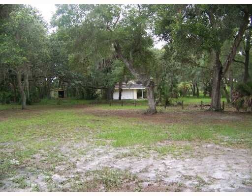
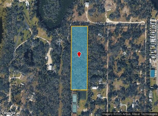
1210 133Rd Ct Ne
North Port-Sarasota-Bradenton, FL
Acreage
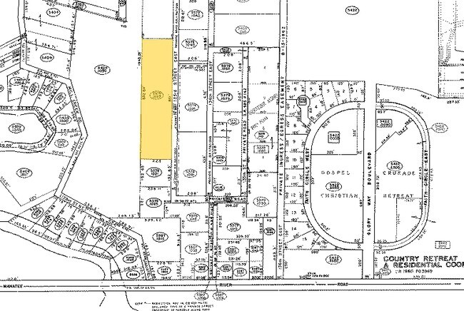
5379-1028-9
THE N 854 FT OF THE FOLLOWING DESC PARCEL: COM AT THE NE COR OF THE NW1/4 OF THE SE1/4 OF SEC 16, TH S 89 DEG 59 MIN 00 SEC W, ALG THE NLY LN OF SE1/4 A DIST OF 1014.5 FT FOR THE
Vacantlandnec
Manatee
AE
Florida
12081C0195F
4.30 AC
2023
Manatee Outlying
2025
Tampa/St Petersburg
002018
DEMOGRAPHICS near 1210 133Rd Ct Ne
1 Mile
3 Mile
5 Mile
2024 Total Population
2,713
32,344
71,248
2029 Population
3,146
38,163
84,423
Pop Growth 2024-2029
+ 15.96%
+ 17.99%
+ 18.49%
Average Age
42
44
45
2024 Total Households
939
11,701
27,541
HH Growth 2024-2029
+ 15.23%
+ 17.21%
+ 17.63%
Median Household Inc
$118,269
$109,451
$102,299
Avg Household Size
2.80
2.70
2.50
2024 Avg HH Vehicles
2.00
2.00
2.00
Median Home Value
$459,111
$422,908
$390,836
Median Year Built
2002
2009
2010
Nearby Places
Map Layers
Map Styles
 Street
 Aerial
- Restaurants
- Banks
- Shops
- Fitness
- Groceries
PUBLIC TRANSPORTATION
AIRPORT
Sarasota/Bradenton International
DRIVE
WALK
Distance
Sarasota/Bradenton International
36 min
21.9 mi
Freight Ports
Port Manatee
DRIVE
WALK
Distance
Port Manatee
33 min
19.6 mi
Nearby Properties
Address
Land Use
TOTAL SIZE
Lot Size
Zoning
Address
Land Use
TOTAL SIZE
Lot Size
Zoning
628,167 SF
16.77 AC
PD-MU
Address
Land Use
TOTAL SIZE
Lot Size
Zoning
349,074 SF
15.03 AC
PD-MU
Address
Land Use
TOTAL SIZE
Lot Size
Zoning
412,218 SF
19.09 AC
PD-MU
Address
Land Use
TOTAL SIZE
Lot Size
Zoning
282,022 SF
21.30 AC
GC GENERA
Address
Land Use
TOTAL SIZE
Lot Size
Zoning
164,551 SF
31.22 AC
PD-MU
Address
Land Use
TOTAL SIZE
Lot Size
Zoning
47.43 AC
Address
Land Use
TOTAL SIZE
Lot Size
Zoning
197,761 SF
22.73 AC
PD-R,A
Address
Land Use
TOTAL SIZE
Lot Size
Zoning
106,384 SF
15.55 AC
PD-MU
Address
Land Use
TOTAL SIZE
Lot Size
Zoning
57,754 SF
8.53 AC
Address
Land Use
TOTAL SIZE
Lot Size
Zoning
76,172 SF
89.74 AC
Address
Land Use
TOTAL SIZE
Lot Size
Zoning
76,172 SF
92.93 AC
PD-R
Address
Land Use
TOTAL SIZE
Lot Size
Zoning
190.90 AC
PD-R
Address
Land Use
TOTAL SIZE
Lot Size
Zoning
41,621 SF
3.91 AC
PD-MU
Address
Land Use
TOTAL SIZE
Lot Size
Zoning
60,512 SF
2.88 AC
PD-C
Address
Land Use
TOTAL SIZE
Lot Size
Zoning
23,930 SF
23.47 AC
PD-R
Address
Land Use
TOTAL SIZE
Lot Size
Zoning
76.98 AC
Address
Land Use
TOTAL SIZE
Lot Size
Zoning
22,709 SF
187 AC
A GENERAL
Address
Land Use
TOTAL SIZE
Lot Size
Zoning
109.06 AC
Address
Land Use
TOTAL SIZE
Lot Size
Zoning
4.07 AC
Address
Land Use
TOTAL SIZE
Lot Size
Zoning
19,360 SF
3.03 AC
PD-C
Address
Land Use
TOTAL SIZE
Lot Size
Zoning
15,913 SF
1.37 AC
PD-C
Address
Land Use
TOTAL SIZE
Lot Size
Zoning
17.07 AC
A,A-1
Address
Land Use
TOTAL SIZE
Lot Size
Zoning
11,180 SF
2.03 AC
PD-MU
Address
Land Use
TOTAL SIZE
Lot Size
Zoning
3,749 SF
22.25 AC
A GENERAL
Address
Land Use
TOTAL SIZE
Lot Size
Zoning
113.80 AC
Address
Land Use
TOTAL SIZE
Lot Size
Zoning
3,604 SF
42.10 AC
A GENERAL
Address
Land Use
TOTAL SIZE
Lot Size
Zoning
0.82 AC
R-M
Address
Land Use
TOTAL SIZE
Lot Size
Zoning
28.49 AC
PD-R
Address
Land Use
TOTAL SIZE
Lot Size
Zoning
6,786 SF
2.58 AC
PD-MU
Address
Land Use
TOTAL SIZE
Lot Size
Zoning
6,003 SF
1.25 AC
GC GENERA
The World's #1 Commercial Real Estate Marketplace
Connect with us
© 2025 CoStar Group
The information above has been obtained from sources believed reliable. While we do not doubt its accuracy we have not verified it and make no guarantee, warranty or representation about it. It is your responsibility to independently confirm its accuracy and completeness. Any projections, opinions, assumptions, or estimates used are for example only and do not represent the current or future performance of the property. The value of this transaction to you depends on tax and other factors which should be evaluated by your tax, financial, and legal advisors. You and your advisors should conduct a careful, independent investigation of the property to determine to your satisfaction the suitability of the property for your needs.