Property Record
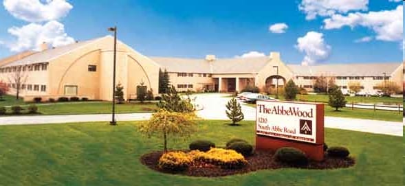
1210 Abbe Rd S, Elyria, OH 44035

Property Detail
1210 Abbe Rd S
Cleveland-Elyria, OH
SEE NOTES ON ABATEMENT FROM -043 20020804877
06-25-001-000-197
LORAIN
Retirementnursinghomecombined
Ohio
B and X Area of moderate flood hazard, usually the area between the limits of the 100-year and 500-year floods.
1
2024
7.80 AC
2024
Lorain County
071202
Cleveland
141,945 SF
NEARBY LISTINGS FOR SALE OR LEASE
-
-
View all Elyria listings for sale on LoopNet.com
DEMOGRAPHICS near 1210 Abbe Rd S
1 mile
3 mile
5 mile
2025 Total Population
10,305
53,005
95,794
2030 Population
10,484
54,215
98,071
Pop Growth 2025-2030
+ 1.74%
+ 2.28%
+ 2.38%
Average Age
42
42
42
2025 Total Households
4,465
22,405
40,219
HH Growth 2025-2030
+ 1.77%
+ 2.30%
+ 2.43%
Median Household Inc
$67,476
$65,682
$72,647
Avg Household Size
2.30
2.30
2.30
2025 Avg HH Vehicles
2.00
2.00
2.00
Median Home Value
$166,151
$178,811
$199,142
Median Year Built
1973
1964
1970
Nearby Places
Map Layers
Map Styles
 Street
 Aerial
Layers
 Traffic
 Biking
Places
Listings with unknown addresses are not visible on the map
- Restaurants
- Banks
- Shops
- Fitness
- Groceries
PUBLIC TRANSPORTATION
COMMUTER RAIL
Elyria Amtrak (Capitol Limited - Amtrak, Lake Shore Limited - Amtrak)
Drive
Walk
Distance
Elyria Amtrak (Capitol Limited - Amtrak, Lake Shore Limited - Amtrak)
4 min
1.7 mi
AIRPORT
Cleveland-Hopkins International
Drive
Walk
Distance
Cleveland-Hopkins International
26 min
17.7 mi
Freight Ports
Port of Toledo
Drive
Walk
Distance
Port of Toledo
111 min
92.2 mi
Nearby Properties
Address
Land Use
TOTAL SIZE
Lot Size
Zoning
Address
Land Use
TOTAL SIZE
Lot Size
Zoning
427,871 SF
6.24 AC
Address
Land Use
TOTAL SIZE
Lot Size
Zoning
351,623 SF
3.13 AC
Address
Land Use
TOTAL SIZE
Lot Size
Zoning
199,200 SF
1.77 AC
Address
Land Use
TOTAL SIZE
Lot Size
Zoning
264,274 SF
15.03 AC
Address
Land Use
TOTAL SIZE
Lot Size
Zoning
128,869 SF
30.06 AC
Address
Land Use
TOTAL SIZE
Lot Size
Zoning
129,277 SF
17.35 AC
Address
Land Use
TOTAL SIZE
Lot Size
Zoning
61,570 SF
0.20 AC
Address
Land Use
TOTAL SIZE
Lot Size
Zoning
150,180 SF
20.21 AC
Address
Land Use
TOTAL SIZE
Lot Size
Zoning
346,114 SF
37.97 AC
Address
Land Use
TOTAL SIZE
Lot Size
Zoning
115,734 SF
29.86 AC
Address
Land Use
TOTAL SIZE
Lot Size
Zoning
107,576 SF
14.79 AC
Address
Land Use
TOTAL SIZE
Lot Size
Zoning
Address
Land Use
TOTAL SIZE
Lot Size
Zoning
206,128 SF
19.97 AC
Address
Land Use
TOTAL SIZE
Lot Size
Zoning
79,556 SF
17.55 AC
Address
Land Use
TOTAL SIZE
Lot Size
Zoning
106,938 SF
1.12 AC
Address
Land Use
TOTAL SIZE
Lot Size
Zoning
32,784 SF
0.25 AC
Address
Land Use
TOTAL SIZE
Lot Size
Zoning
126,448 SF
22.54 AC
Address
Land Use
TOTAL SIZE
Lot Size
Zoning
115,898 SF
8.67 AC
Address
Land Use
TOTAL SIZE
Lot Size
Zoning
158,510 SF
6.01 AC
Address
Land Use
TOTAL SIZE
Lot Size
Zoning
169,280 SF
15.56 AC
Address
Land Use
TOTAL SIZE
Lot Size
Zoning
61,278 SF
8.25 AC
Address
Land Use
TOTAL SIZE
Lot Size
Zoning
40,000 SF
4.20 AC
Address
Land Use
TOTAL SIZE
Lot Size
Zoning
57,634 SF
4.73 AC
Address
Land Use
TOTAL SIZE
Lot Size
Zoning
151,565 SF
0.11 AC
Address
Land Use
TOTAL SIZE
Lot Size
Zoning
39,249 SF
0.74 AC
Address
Land Use
TOTAL SIZE
Lot Size
Zoning
76,610 SF
2.49 AC
Address
Land Use
TOTAL SIZE
Lot Size
Zoning
100,025 SF
9.06 AC
Address
Land Use
TOTAL SIZE
Lot Size
Zoning
29,864 SF
3.96 AC
Address
Land Use
TOTAL SIZE
Lot Size
Zoning
80,160 SF
4.67 AC
The World's #1 Commercial Real Estate Marketplace
Connect with us
© 2026 CoStar Group
The information above has been obtained from sources believed reliable. While we do not doubt its accuracy we have not verified it and make no guarantee, warranty or representation about it. It is your responsibility to independently confirm its accuracy and completeness. Any projections, opinions, assumptions, or estimates used are for example only and do not represent the current or future performance of the property. The value of this transaction to you depends on tax and other factors which should be evaluated by your tax, financial, and legal advisors. You and your advisors should conduct a careful, independent investigation of the property to determine to your satisfaction the suitability of the property for your needs.