Property Record
1210 E Lugonia Ave, Redlands, CA 92374
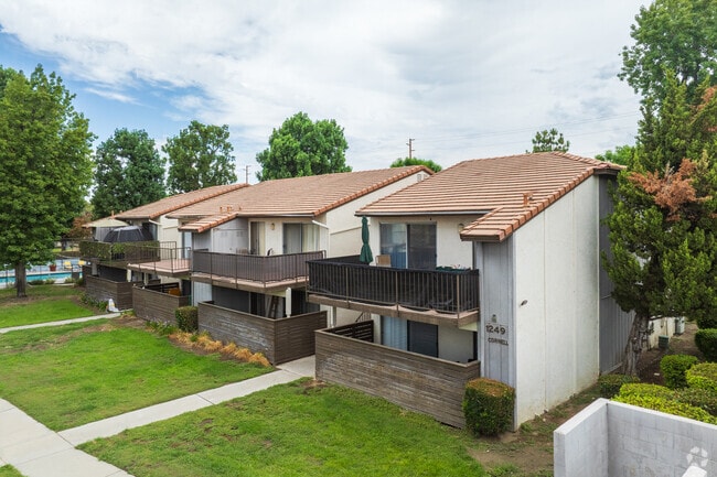


Property Detail
1210 E Lugonia Ave
1212-401-01
PARCEL MAP 8530 PARCEL 1
Apartment
SAN BERNARDINO
B and X Area of moderate flood hazard, usually the area between the limits of the 100-year and 500-year floods.
California
2025
11.74 AC
2025
North Redlands
008406
Inland Empire (California)
166,788 SF
Riverside-San Bernardino-Ontario, CA
NEARBY LISTINGS FOR SALE OR LEASE
-
-
View all Redlands listings for sale on LoopNet.com
DEMOGRAPHICS near 1210 E Lugonia Ave
1 mile
3 mile
5 mile
2025 Total Population
19,594
75,711
141,137
2030 Population
19,834
76,657
143,073
Pop Growth 2025-2030
+ 1.22%
+ 1.25%
+ 1.37%
Average Age
36
39
39
2025 Total Households
6,266
26,872
48,831
HH Growth 2025-2030
+ 1.45%
+ 1.33%
+ 1.45%
Median Household Inc
$96,078
$99,014
$103,008
Avg Household Size
2.90
2.70
2.80
2025 Avg HH Vehicles
2.00
2.00
2.00
Median Home Value
$569,590
$626,143
$630,475
Median Year Built
1978
1977
1981
Nearby Places
Map Layers
Map Styles
 Street
 Aerial
Layers
 Traffic
 Biking
Places
Listings with unknown addresses are not visible on the map
- Restaurants
- Banks
- Shops
- Fitness
- Groceries
PUBLIC TRANSPORTATION
COMMUTER RAIL
Redlands - University Metrolink Station (Metrolink San Bernardino Line - Metrolink Trains)
Drive
Walk
Distance
Redlands - University Metrolink Station (Metrolink San Bernardino Line - Metrolink Trains)
4 min
1.4 mi
Redlands - Downtown Metrolink Station (Metrolink San Bernardino Line - Metrolink Trains)
Drive
Walk
Distance
Redlands - Downtown Metrolink Station (Metrolink San Bernardino Line - Metrolink Trains)
5 min
2.2 mi
AIRPORT
Ontario International
Drive
Walk
Distance
Ontario International
35 min
26.7 mi
Freight Ports
Port of Long Beach
Drive
Walk
Distance
Port of Long Beach
92 min
72.1 mi
Nearby Properties
Address
Land Use
TOTAL SIZE
Lot Size
Zoning
Address
Land Use
TOTAL SIZE
Lot Size
Zoning
393,088 SF
25.98 AC
Address
Land Use
TOTAL SIZE
Lot Size
Zoning
460,038 SF
22.70 AC
Address
Land Use
TOTAL SIZE
Lot Size
Zoning
329,075 SF
10.93 AC
Address
Land Use
TOTAL SIZE
Lot Size
Zoning
56.83 AC
Address
Land Use
TOTAL SIZE
Lot Size
Zoning
777,580 SF
23.13 AC
Address
Land Use
TOTAL SIZE
Lot Size
Zoning
801,126 SF
36.03 AC
Address
Land Use
TOTAL SIZE
Lot Size
Zoning
593,615 SF
27.54 AC
EVCG
Address
Land Use
TOTAL SIZE
Lot Size
Zoning
542,519 SF
27.07 AC
Address
Land Use
TOTAL SIZE
Lot Size
Zoning
205,555 SF
6.39 AC
Address
Land Use
TOTAL SIZE
Lot Size
Zoning
714,538 SF
56.66 AC
Address
Land Use
TOTAL SIZE
Lot Size
Zoning
9.50 AC
Address
Land Use
TOTAL SIZE
Lot Size
Zoning
313,470 SF
14.82 AC
Address
Land Use
TOTAL SIZE
Lot Size
Zoning
221,914 SF
4.50 AC
Address
Land Use
TOTAL SIZE
Lot Size
Zoning
184,201 SF
6.08 AC
Address
Land Use
TOTAL SIZE
Lot Size
Zoning
285,952 SF
13.31 AC
Address
Land Use
TOTAL SIZE
Lot Size
Zoning
112,907 SF
3.59 AC
Address
Land Use
TOTAL SIZE
Lot Size
Zoning
169,312 SF
10.99 AC
Address
Land Use
TOTAL SIZE
Lot Size
Zoning
153,344 SF
7.30 AC
Address
Land Use
TOTAL SIZE
Lot Size
Zoning
190,086 SF
8.48 AC
EVSDCOM
Address
Land Use
TOTAL SIZE
Lot Size
Zoning
82,356 SF
5.10 AC
RM
Address
Land Use
TOTAL SIZE
Lot Size
Zoning
95,525 SF
4.53 AC
Address
Land Use
TOTAL SIZE
Lot Size
Zoning
86,649 SF
3.73 AC
EVSDCOM
Address
Land Use
TOTAL SIZE
Lot Size
Zoning
164,794 SF
1.32 AC
Address
Land Use
TOTAL SIZE
Lot Size
Zoning
89,705 SF
2.78 AC
Address
Land Use
TOTAL SIZE
Lot Size
Zoning
104,067 SF
Address
Land Use
TOTAL SIZE
Lot Size
Zoning
147,280 SF
9.83 AC
Address
Land Use
TOTAL SIZE
Lot Size
Zoning
80,673 SF
0.96 AC
Address
Land Use
TOTAL SIZE
Lot Size
Zoning
81,275 SF
5.56 AC
Address
Land Use
TOTAL SIZE
Lot Size
Zoning
74,207 SF
2.66 AC
The World's #1 Commercial Real Estate Marketplace
Connect with us
© 2026 CoStar Group
The information above has been obtained from sources believed reliable. While we do not doubt its accuracy we have not verified it and make no guarantee, warranty or representation about it. It is your responsibility to independently confirm its accuracy and completeness. Any projections, opinions, assumptions, or estimates used are for example only and do not represent the current or future performance of the property. The value of this transaction to you depends on tax and other factors which should be evaluated by your tax, financial, and legal advisors. You and your advisors should conduct a careful, independent investigation of the property to determine to your satisfaction the suitability of the property for your needs.