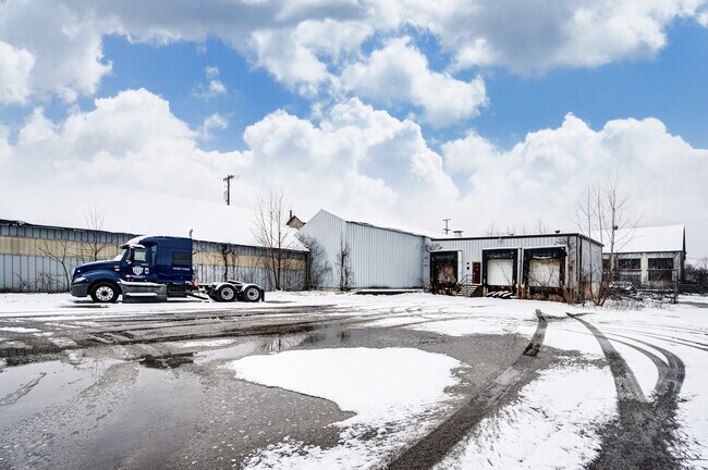
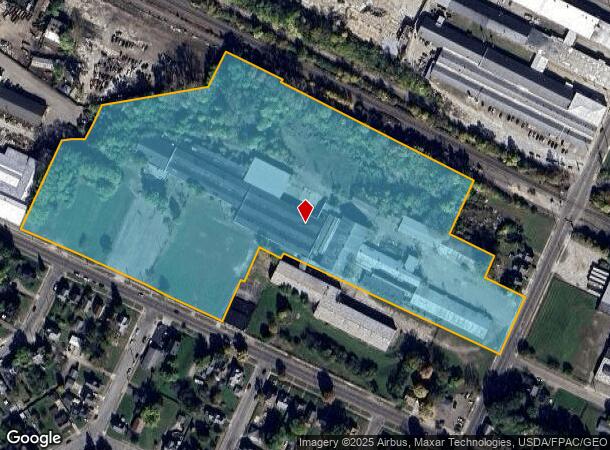
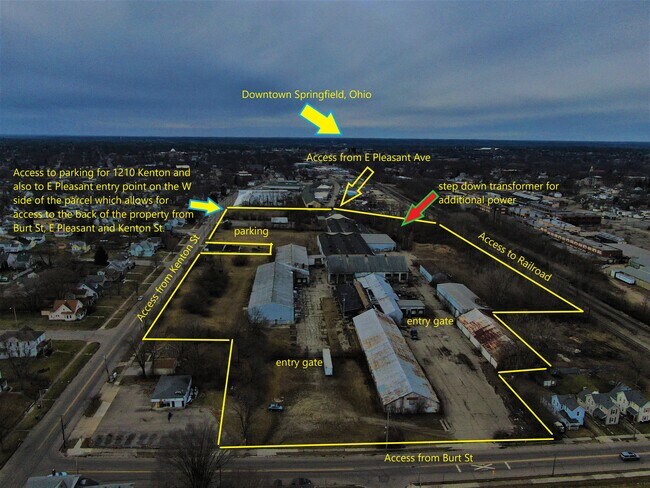
Property Record
1210 Kenton St, Springfield, OH 45505
NEARBY LISTINGS FOR SALE OR LEASE
Property Detail
1210 Kenton St
34-00700-02840-4019
W OF BURT ST TRACT 7 S OF C C C & ST L RR & N SIDE KENTON E OF EAST
Municipalproperty
Clark
A
Ohio
39023C0191E
19
2023
16.16 AC
2024
Northeast Dayton
001300
Cincinnati/Dayton
157,586 SF
Springfield, OH
DEMOGRAPHICS near 1210 Kenton St
1 Mile
3 Mile
5 Mile
2024 Total Population
12,899
59,696
79,308
2029 Population
12,979
59,861
79,228
Pop Growth 2024-2029
+ 0.62%
+ 0.28%
(0.10%)
Average Age
37
39
40
2024 Total Households
5,341
24,015
32,760
HH Growth 2024-2029
+ 0.49%
+ 0.21%
(0.19%)
Median Household Inc
$38,706
$45,601
$49,958
Avg Household Size
2.30
2.30
2.30
2024 Avg HH Vehicles
2.00
2.00
2.00
Median Home Value
$67,078
$97,744
$129,017
Median Year Built
1947
1949
1955
Nearby Places
Map Layers
Map Styles
 Street
 Aerial
- Restaurants
- Banks
- Shops
- Fitness
- Groceries
PUBLIC TRANSPORTATION
AIRPORT
James M Cox Dayton International
DRIVE
WALK
Distance
James M Cox Dayton International
38 min
28.1 mi
Freight Ports
Port of Toledo
DRIVE
WALK
Distance
Port of Toledo
192 min
132.3 mi
SALE & LEASE HISTORY
LISTING DATE
SALE/LEASE

Sep 24, 2016
For Lease
Feb 29, 2020
For Sale
Nearby Properties
Address
Land Use
TOTAL SIZE
Lot Size
Zoning
Address
Land Use
TOTAL SIZE
Lot Size
Zoning
1.20 AC
Address
Land Use
TOTAL SIZE
Lot Size
Zoning
479,515 SF
1.69 AC
Address
Land Use
TOTAL SIZE
Lot Size
Zoning
32.89 AC
Address
Land Use
TOTAL SIZE
Lot Size
Zoning
107.87 AC
Address
Land Use
TOTAL SIZE
Lot Size
Zoning
17,280 SF
14.32 AC
Address
Land Use
TOTAL SIZE
Lot Size
Zoning
Address
Land Use
TOTAL SIZE
Lot Size
Zoning
44.85 AC
Address
Land Use
TOTAL SIZE
Lot Size
Zoning
103,458 SF
5.51 AC
Address
Land Use
TOTAL SIZE
Lot Size
Zoning
399,308 SF
11.06 AC
Address
Land Use
TOTAL SIZE
Lot Size
Zoning
8,316 SF
34.41 AC
R-1
Address
Land Use
TOTAL SIZE
Lot Size
Zoning
61,376 SF
3.95 AC
Address
Land Use
TOTAL SIZE
Lot Size
Zoning
25.44 AC
Address
Land Use
TOTAL SIZE
Lot Size
Zoning
28,105 SF
1.40 AC
Address
Land Use
TOTAL SIZE
Lot Size
Zoning
Address
Land Use
TOTAL SIZE
Lot Size
Zoning
Address
Land Use
TOTAL SIZE
Lot Size
Zoning
Address
Land Use
TOTAL SIZE
Lot Size
Zoning
Address
Land Use
TOTAL SIZE
Lot Size
Zoning
211,877 SF
24.01 AC
Address
Land Use
TOTAL SIZE
Lot Size
Zoning
6,521 SF
94.30 AC
Address
Land Use
TOTAL SIZE
Lot Size
Zoning
1.05 AC
Address
Land Use
TOTAL SIZE
Lot Size
Zoning
217,626 SF
17.85 AC
Address
Land Use
TOTAL SIZE
Lot Size
Zoning
56,381 SF
0.22 AC
Address
Land Use
TOTAL SIZE
Lot Size
Zoning
32,566 SF
1.90 AC
Address
Land Use
TOTAL SIZE
Lot Size
Zoning
Address
Land Use
TOTAL SIZE
Lot Size
Zoning
Address
Land Use
TOTAL SIZE
Lot Size
Zoning
Address
Land Use
TOTAL SIZE
Lot Size
Zoning
Address
Land Use
TOTAL SIZE
Lot Size
Zoning
Address
Land Use
TOTAL SIZE
Lot Size
Zoning
26.78 AC
Address
Land Use
TOTAL SIZE
Lot Size
Zoning
The World's #1 Commercial Real Estate Marketplace
Connect with us
© 2025 CoStar Group
The information above has been obtained from sources believed reliable. While we do not doubt its accuracy we have not verified it and make no guarantee, warranty or representation about it. It is your responsibility to independently confirm its accuracy and completeness. Any projections, opinions, assumptions, or estimates used are for example only and do not represent the current or future performance of the property. The value of this transaction to you depends on tax and other factors which should be evaluated by your tax, financial, and legal advisors. You and your advisors should conduct a careful, independent investigation of the property to determine to your satisfaction the suitability of the property for your needs.