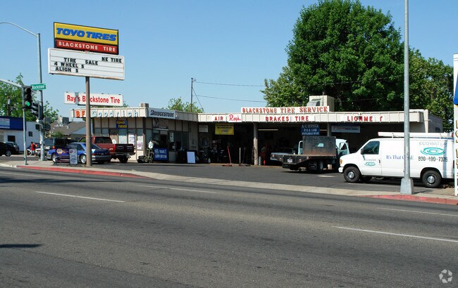
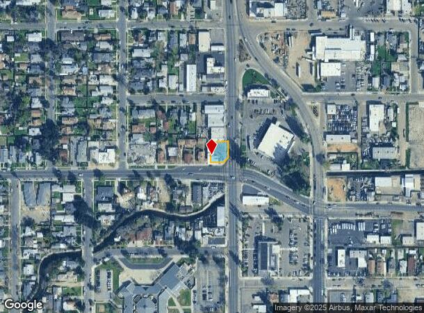
Property Record
1201 N Blackstone Ave, Fresno, CA 93703

NEARBY LISTINGS FOR SALE OR LEASE
Property Detail
1201 N Blackstone Ave
Fresno, CA
Zapps Park
451-285-15
PARCEL IN E 78 FT OF LOTS 50-54 ZAPPS PARK
Autorepair
Fresno
X
California
06019C1570H
51
2025
0.19 AC
2025
South Blackstone
002300
Fresno
1,920 SF
DEMOGRAPHICS near 1201 N Blackstone Ave
1 Mile
3 Mile
5 Mile
2024 Total Population
21,475
176,488
372,002
2029 Population
21,948
179,617
378,819
Pop Growth 2024-2029
+ 2.20%
+ 1.77%
+ 1.83%
Average Age
34
34
34
2024 Total Households
7,343
54,374
117,374
HH Growth 2024-2029
+ 2.12%
+ 1.80%
+ 1.88%
Median Household Inc
$34,871
$40,648
$45,921
Avg Household Size
2.80
3.10
3.00
2024 Avg HH Vehicles
1.00
2.00
2.00
Median Home Value
$238,277
$230,764
$252,681
Median Year Built
1953
1957
1967
Nearby Places
Map Layers
Map Styles
 Street
 Aerial
- Restaurants
- Banks
- Shops
- Fitness
- Groceries
PUBLIC TRANSPORTATION
COMMUTER RAIL
Fresno (San Joaquins - Amtrak)
DRIVE
WALK
Distance
Fresno (San Joaquins - Amtrak)
4 min
1.9 mi
AIRPORT
Fresno Yosemite International
DRIVE
WALK
Distance
Fresno Yosemite International
10 min
5.1 mi
Freight Ports
Port of Stockton
DRIVE
WALK
Distance
Port of Stockton
152 min
127.9 mi
Nearby Properties
Address
Land Use
TOTAL SIZE
Lot Size
Zoning
Address
Land Use
TOTAL SIZE
Lot Size
Zoning
534,993 SF
5.23 AC
CP
Address
Land Use
TOTAL SIZE
Lot Size
Zoning
0.01 AC
P
Address
Land Use
TOTAL SIZE
Lot Size
Zoning
288,597 SF
1.18 AC
C4
Address
Land Use
TOTAL SIZE
Lot Size
Zoning
147,101 SF
6.31 AC
SPLIT
Address
Land Use
TOTAL SIZE
Lot Size
Zoning
184,130 SF
1.87 AC
PI
Address
Land Use
TOTAL SIZE
Lot Size
Zoning
101,510 SF
3.37 AC
CM
Address
Land Use
TOTAL SIZE
Lot Size
Zoning
471,760 SF
1.98 AC
CP
Address
Land Use
TOTAL SIZE
Lot Size
Zoning
213,874 SF
4.17 AC
SPLIT
Address
Land Use
TOTAL SIZE
Lot Size
Zoning
206,766 SF
17.11 AC
R2
Address
Land Use
TOTAL SIZE
Lot Size
Zoning
79,518 SF
2.03 AC
R4
Address
Land Use
TOTAL SIZE
Lot Size
Zoning
480,570 SF
2.98 AC
P
Address
Land Use
TOTAL SIZE
Lot Size
Zoning
90,500 SF
1.29 AC
CM
Address
Land Use
TOTAL SIZE
Lot Size
Zoning
110,456 SF
6.56 AC
RMX
Address
Land Use
TOTAL SIZE
Lot Size
Zoning
314,915 SF
14.12 AC
M2
Address
Land Use
TOTAL SIZE
Lot Size
Zoning
96,012 SF
1.33 AC
C4
Address
Land Use
TOTAL SIZE
Lot Size
Zoning
669,447 SF
0.01 AC
C3
Address
Land Use
TOTAL SIZE
Lot Size
Zoning
82,096 SF
0.26 AC
C4
Address
Land Use
TOTAL SIZE
Lot Size
Zoning
96,012 SF
0.60 AC
C4
Address
Land Use
TOTAL SIZE
Lot Size
Zoning
203,687 SF
10.63 AC
R3
Address
Land Use
TOTAL SIZE
Lot Size
Zoning
121,250 SF
9.51 AC
R3
Address
Land Use
TOTAL SIZE
Lot Size
Zoning
141,577 SF
12.76 AC
IL
Address
Land Use
TOTAL SIZE
Lot Size
Zoning
110,341 SF
5.45 AC
R3
Address
Land Use
TOTAL SIZE
Lot Size
Zoning
89,097 SF
0.63 AC
CC
Address
Land Use
TOTAL SIZE
Lot Size
Zoning
191,136 SF
12.12 AC
R2
Address
Land Use
TOTAL SIZE
Lot Size
Zoning
92,096 SF
0.01 AC
C3
Address
Land Use
TOTAL SIZE
Lot Size
Zoning
91,517 SF
1.80 AC
SPLIT
Address
Land Use
TOTAL SIZE
Lot Size
Zoning
108,017 SF
2.91 AC
CM
Address
Land Use
TOTAL SIZE
Lot Size
Zoning
372,640 SF
4.35 AC
CP
Address
Land Use
TOTAL SIZE
Lot Size
Zoning
37,017 SF
1.19 AC
CM
Address
Land Use
TOTAL SIZE
Lot Size
Zoning
173,949 SF
11.53 AC
M2
The World's #1 Commercial Real Estate Marketplace
Connect with us
© 2026 CoStar Group
The information above has been obtained from sources believed reliable. While we do not doubt its accuracy we have not verified it and make no guarantee, warranty or representation about it. It is your responsibility to independently confirm its accuracy and completeness. Any projections, opinions, assumptions, or estimates used are for example only and do not represent the current or future performance of the property. The value of this transaction to you depends on tax and other factors which should be evaluated by your tax, financial, and legal advisors. You and your advisors should conduct a careful, independent investigation of the property to determine to your satisfaction the suitability of the property for your needs.