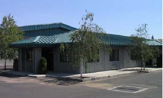
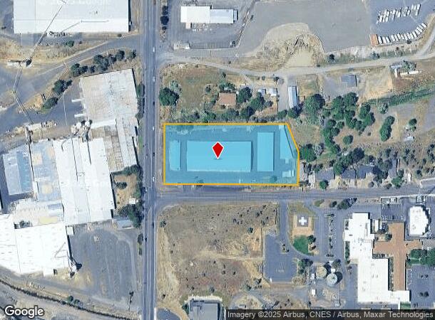
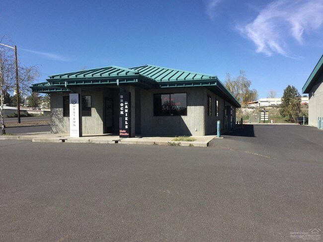
Property Record
1210 N Main St, Prineville, OR 97754

NEARBY LISTINGS FOR SALE OR LEASE
Property Detail
1210 N Main St
Prineville, OR
Part Plat Year & # No Parcel #
141632CB01405
SECTION 32 TOWNSHIP 14S RANGE 16E QUARTER SW PCRL 1405 SUBDIVISION: PART PLAT YEAR & # NO PARCEL # BLOCK: 93 LOT: 17 MAPTAXLOT: 141632CB01405
Commercialnec
Crook
X
Oregon
41013C0411C
17
2025
2.84 AC
2025
Bend/Redmond
950102
Other Market Areas
2,880 SF
DEMOGRAPHICS near 1210 N Main St
1 Mile
3 Mile
5 Mile
2024 Total Population
8,400
14,441
16,509
2029 Population
9,824
16,866
19,276
Pop Growth 2024-2029
+ 16.95%
+ 16.79%
+ 16.76%
Average Age
41
42
42
2024 Total Households
3,401
5,740
6,581
HH Growth 2024-2029
+ 17.17%
+ 17.02%
+ 17.00%
Median Household Inc
$56,843
$58,133
$61,514
Avg Household Size
2.40
2.40
2.40
2024 Avg HH Vehicles
2.00
2.00
2.00
Median Home Value
$299,906
$320,201
$338,036
Median Year Built
1986
1979
1983
Nearby Places
Map Layers
Map Styles
 Street
 Aerial
- Restaurants
- Banks
- Shops
- Fitness
- Groceries
PUBLIC TRANSPORTATION
AIRPORT
Roberts Field
DRIVE
WALK
Distance
Roberts Field
25 min
19.5 mi
SALE & LEASE HISTORY
LISTING DATE
SALE/LEASE

Sep 24, 2016
For Sale
Nearby Properties
Address
Land Use
TOTAL SIZE
Lot Size
Zoning
Address
Land Use
TOTAL SIZE
Lot Size
Zoning
Address
Land Use
TOTAL SIZE
Lot Size
Zoning
1 SF
15.01 AC
R2
Address
Land Use
TOTAL SIZE
Lot Size
Zoning
68,850 SF
1.38 AC
C1
Address
Land Use
TOTAL SIZE
Lot Size
Zoning
6.16 AC
R2
Address
Land Use
TOTAL SIZE
Lot Size
Zoning
4.70 AC
C2
Address
Land Use
TOTAL SIZE
Lot Size
Zoning
1 SF
8.02 AC
C2
Address
Land Use
TOTAL SIZE
Lot Size
Zoning
202.87 AC
PR
Address
Land Use
TOTAL SIZE
Lot Size
Zoning
33,854 SF
1.52 AC
R4
Address
Land Use
TOTAL SIZE
Lot Size
Zoning
1 SF
2.24 AC
R2
Address
Land Use
TOTAL SIZE
Lot Size
Zoning
7,089 SF
46.68 AC
C5
Address
Land Use
TOTAL SIZE
Lot Size
Zoning
1 SF
1.25 AC
R2
Address
Land Use
TOTAL SIZE
Lot Size
Zoning
34,483 SF
5.80 AC
C2
Address
Land Use
TOTAL SIZE
Lot Size
Zoning
83,366 SF
2.10 AC
M1
Address
Land Use
TOTAL SIZE
Lot Size
Zoning
38,165 SF
1.38 AC
C2
Address
Land Use
TOTAL SIZE
Lot Size
Zoning
80.35 AC
M1
Address
Land Use
TOTAL SIZE
Lot Size
Zoning
1 SF
13.67 AC
M2
Address
Land Use
TOTAL SIZE
Lot Size
Zoning
5.15 AC
M1
Address
Land Use
TOTAL SIZE
Lot Size
Zoning
35,030 SF
2.90 AC
C2
Address
Land Use
TOTAL SIZE
Lot Size
Zoning
Address
Land Use
TOTAL SIZE
Lot Size
Zoning
22,650 SF
5 AC
C2
Address
Land Use
TOTAL SIZE
Lot Size
Zoning
1 SF
37.07 AC
R2
Address
Land Use
TOTAL SIZE
Lot Size
Zoning
1 SF
15.48 AC
IP
Address
Land Use
TOTAL SIZE
Lot Size
Zoning
31,344 SF
2.39 AC
C2
Address
Land Use
TOTAL SIZE
Lot Size
Zoning
24,148 SF
1.55 AC
C2
Address
Land Use
TOTAL SIZE
Lot Size
Zoning
18,615 SF
1 AC
R2
Address
Land Use
TOTAL SIZE
Lot Size
Zoning
12,887 SF
0.70 AC
C1
Address
Land Use
TOTAL SIZE
Lot Size
Zoning
25,576 SF
1.50 AC
C2
Address
Land Use
TOTAL SIZE
Lot Size
Zoning
57,708 SF
7.63 AC
HM
Address
Land Use
TOTAL SIZE
Lot Size
Zoning
1 SF
22.48 AC
M2
Address
Land Use
TOTAL SIZE
Lot Size
Zoning
59,500 SF
5.08 AC
IP
The World's #1 Commercial Real Estate Marketplace
Connect with us
© 2026 CoStar Group
The information above has been obtained from sources believed reliable. While we do not doubt its accuracy we have not verified it and make no guarantee, warranty or representation about it. It is your responsibility to independently confirm its accuracy and completeness. Any projections, opinions, assumptions, or estimates used are for example only and do not represent the current or future performance of the property. The value of this transaction to you depends on tax and other factors which should be evaluated by your tax, financial, and legal advisors. You and your advisors should conduct a careful, independent investigation of the property to determine to your satisfaction the suitability of the property for your needs.