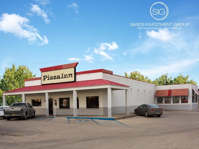
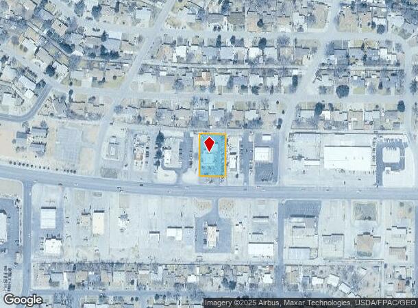
Property Record
1210 W Pierce St, Carlsbad, NM 88220

NEARBY LISTINGS FOR SALE OR LEASE
Property Detail
1210 W Pierce St
4-156-126-384-268
QUARTER: NE S: 36 T: 21S R: 26E BEG INTERSECTION OF E ROW GEORGE ST & ALLEY BDRY SOUTH SHORE #2 SUBD, S85 13'E 368.34', S89 2
Realpropertynec
Eddy
X
New Mexico
35015C1065D
0.59 AC
2025
Other Market Areas
2025
Carlsbad-Artesia, NM
000300
DEMOGRAPHICS near 1210 W Pierce St
1 Mile
3 Mile
5 Mile
2024 Total Population
11,843
27,670
35,676
2029 Population
11,695
27,219
35,111
Pop Growth 2024-2029
(1.25%)
(1.63%)
(1.58%)
Average Age
38
38
38
2024 Total Households
4,478
10,331
13,083
HH Growth 2024-2029
(1.27%)
(1.66%)
(1.63%)
Median Household Inc
$72,078
$70,004
$69,540
Avg Household Size
2.60
2.60
2.60
2024 Avg HH Vehicles
2.00
2.00
2.00
Median Home Value
$178,603
$178,048
$174,814
Median Year Built
1964
1966
1972
Nearby Places
Map Layers
Map Styles
 Street
 Aerial
- Restaurants
- Banks
- Shops
- Fitness
- Groceries
SALE & LEASE HISTORY
LISTING DATE
SALE/LEASE

Jan 27, 2017
For Sale
Nearby Properties
Address
Land Use
TOTAL SIZE
Lot Size
Zoning
Address
Land Use
TOTAL SIZE
Lot Size
Zoning
Address
Land Use
TOTAL SIZE
Lot Size
Zoning
Address
Land Use
TOTAL SIZE
Lot Size
Zoning
70.20 AC
Address
Land Use
TOTAL SIZE
Lot Size
Zoning
16,590 SF
79.62 AC
Address
Land Use
TOTAL SIZE
Lot Size
Zoning
40.31 AC
Address
Land Use
TOTAL SIZE
Lot Size
Zoning
Address
Land Use
TOTAL SIZE
Lot Size
Zoning
Address
Land Use
TOTAL SIZE
Lot Size
Zoning
12.97 AC
Address
Land Use
TOTAL SIZE
Lot Size
Zoning
Address
Land Use
TOTAL SIZE
Lot Size
Zoning
4.50 AC
Address
Land Use
TOTAL SIZE
Lot Size
Zoning
2.57 AC
Address
Land Use
TOTAL SIZE
Lot Size
Zoning
Address
Land Use
TOTAL SIZE
Lot Size
Zoning
15.69 AC
Address
Land Use
TOTAL SIZE
Lot Size
Zoning
47.01 AC
Address
Land Use
TOTAL SIZE
Lot Size
Zoning
8.85 AC
Address
Land Use
TOTAL SIZE
Lot Size
Zoning
Address
Land Use
TOTAL SIZE
Lot Size
Zoning
6.16 AC
Address
Land Use
TOTAL SIZE
Lot Size
Zoning
1.88 AC
Address
Land Use
TOTAL SIZE
Lot Size
Zoning
11.55 AC
Address
Land Use
TOTAL SIZE
Lot Size
Zoning
0.77 AC
Address
Land Use
TOTAL SIZE
Lot Size
Zoning
0.51 AC
Address
Land Use
TOTAL SIZE
Lot Size
Zoning
7.21 AC
Address
Land Use
TOTAL SIZE
Lot Size
Zoning
1,860 SF
Address
Land Use
TOTAL SIZE
Lot Size
Zoning
60,041 SF
6.43 AC
Address
Land Use
TOTAL SIZE
Lot Size
Zoning
21.78 AC
Address
Land Use
TOTAL SIZE
Lot Size
Zoning
Address
Land Use
TOTAL SIZE
Lot Size
Zoning
12,921 SF
1.56 AC
Address
Land Use
TOTAL SIZE
Lot Size
Zoning
48,144 SF
3.38 AC
Address
Land Use
TOTAL SIZE
Lot Size
Zoning
10.07 AC
Address
Land Use
TOTAL SIZE
Lot Size
Zoning
0.19 AC
The World's #1 Commercial Real Estate Marketplace
Connect with us
© 2025 CoStar Group
The information above has been obtained from sources believed reliable. While we do not doubt its accuracy we have not verified it and make no guarantee, warranty or representation about it. It is your responsibility to independently confirm its accuracy and completeness. Any projections, opinions, assumptions, or estimates used are for example only and do not represent the current or future performance of the property. The value of this transaction to you depends on tax and other factors which should be evaluated by your tax, financial, and legal advisors. You and your advisors should conduct a careful, independent investigation of the property to determine to your satisfaction the suitability of the property for your needs.